Select High Quality Natural Communities
20 likes | 154 Views
Select High Quality Natural Communities. Identify Potential Restoration Sites (RPs). MLCCS. Restoration Prioritization and Prediction Model (RePP).

Select High Quality Natural Communities
E N D
Presentation Transcript
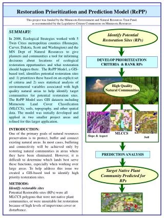
Select High Quality Natural Communities Identify Potential Restoration Sites (RPs) MLCCS Restoration Prioritization and Prediction Model (RePP) This project was funded by the Minnesota Environment and Natural Resources Trust Fund, as recommended by the Legislative-Citizen Commission on Minnesota Resources SUMMARY: In 2008, Ecological Strategies worked with 5 Twin Cities metropolitan counties (Hennepin, Carver, Dakota, Scott and Washington) and the MN Dept of Natural Resources to give planners and communities a tool for informing decisions about locations of ecological restoration opportunities and what restoration should happen there. The RePP Model, a GIS-based tool, identifies potential restoration sites and: 1) prioritizes these based on an explicit set of criteria and 2) uses statistical analysis of environmental variables associated with high quality natural areas to help identify target communities for potential restoration sites. The RePP Model uses GIS datasets including Minnesota Land Cover Classification (MLCCS), soils, topography, and other spatial data. The model was initially developed and applied in two smaller project areas and refined for this larger application. DEVELOP PRIORITIZATION CRITERIA & RANK RPs High Quality Natural Communities INTRODUCTION: One of the primary goals of natural resources preservation is to protect, buffer and connect existing natural areas. In most cases, buffering and connectivity will be achieved only by restoring natural communities in areas where they have been eliminated. However, it is difficult to determine which lands best serve these functions, especially when working over large areas. To help address this issue we created a GIS-based tool to identify high priority restoration sites. Slope & Aspect Soil PREDICTION ANALYSIS Target Native Plant Community Predicted for RPs METHODS: Identify restorable sites Potential Restorable sites (RPs) were all MLCCS polygons that were not native plant communities, or were unsuitable for restoration because of high levels of impervious cover or disturbance.
Restoration Sites Prioritized Legend Rank = 2 medium priority Rank = 3 low priority Forest Prairie & old field Floodplain forest Lakes & Rivers Roads & Impervious 1Map created to give a general idea of how restoration sites might be prioritized. Restoration Prioritization and Prediction Model (RePP) 1 Rank = 1 high priority METHODS continued: Prioritization Criteria Prioritization Criteria were developed to rank RPs based on a literature review and the input of local experts. The ranks were designed to be flexible so that the ranking criteria can be weighted differently, depending on the specific goals of the government agency or community. Prediction Analysis MLCCS, slope, aspect and soil features associated with existing high quality natural communities were analyzed statistically to identify potential restoration sites in the project area. These analyses were then applied to predict target communities for restoration on restorable sites. PRODUCTS: The primary product of the application of the tool is a GIS-based database and shapefile (or map) identifying restoration sites and their priority rankings. The tool also provides guidance on what plant community should be restored on the restoration sites, based on the statistical analyses. The shapefile and workshop handout materials are available at: ftp://ftp.dnr.state.mn.us/pub/gisftp/barichar/restoration_model/ CONTACTS: Carolyn Carr, Ecological Strategies, LLC ccarr@ecologicalstrategies.com 612-721-6021 Dave Thill, Hennepin County Env. Services david.thill@co.hennepin.mn.us 612-348-0124 Bart Richardson, MN DNR bart.richardson@dnr.state.mn.us 651-259-5796