Download
1 / 11
110 likes | 129 Views
This tool allows users to classify land cover based on limited information and store the results. It includes a dichotomous phase and a modular-hierarchical phase, with classifiers and attributes. Users can add user-defined attributes and edit the legend.

E N D
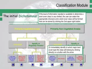
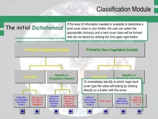
Classification Module If the level of information needed or available to determine a land cover class is very limited, the user can select the appropriate choice(s) and a land cover class will be formed that can be stored by clicking the 2nd upper right button. The initial Dichotomous Phase of LCCS Click one option of each pair of buttons. Or immediately identify to which major land cover type the class will belong by clicking directly on a button with the arrow.
Classification Module The so-called Environmental Attributes are presented in purple and are not hierarchically arranged; the Specific Technical Attribute is presented in green. The subsequent Modular-Hierarchical Phase of LCCS The sets of classifiers tailored to the major land cover and hierarchically arranged according to mapability (classifiers presented in dark blue).
Classification Module I II III IV I II • Modular-Hierarchical Phase:classifiers and attributes • Land Cover Classifiers are hierarchically arranged according to mapability, i.e. geographical accuracy, at the top levels. • Environmental Attributes are not hierarchically arranged and are shown at the intermediate levels. • Specific Technical Attribute is shown at the bottom. The hierarchically arranged land cover classifiers over different levels at the top (in dark blue). Followed by a set of Environmental Attributes (in purple). The Specific Technical Attribute at the bottom (in green).
Classification Module I II III IV Modular-Hierarchical Phase:classifiers in detail To proceed click the upper left button (in the example below “Life Form and Cover ”. A new window will open with a set of options. The classifier Life Form is the first one to be determined.
Classification Module Modular-Hierarchical Phase:classifiers in detail Selection of an option of the classifier Life Form is made by clicking the appropriate button. From the classifier Life Form, the option Trees has been selected. From the classifier Cover the option Closed has been selected. From the classifier Height several options have become automatically disabled.
Classification Module Modular-Hierarchical Phase:classifiers in detail The classifier Life Form is used to illustrate some features. The options of the classifier are mutually exclusive, i.e. the user can select only one option. Furthermore, this particular classifier has a more general level comprising Woody, Herbaceous and Lichens/Mosses, followed by a more specific level comprising Trees and Shrubs, Forbs and Graminoids, and Lichens and Mosses. There are also options that further modify a classifier option, the so-called Modifiers and they immediately follow a classifier option (e.g. for Forbs Rooted and Free-floating in bright blue).
Classification Module Modular-Hierarchical Phase:modifiers in detail • The Modifiers further modify a classifier option and they immediately follow a classifier option. • The selection of Modifiers is optional! • The use of Modifiers will generate: • a separate Boolean Formula; • a distinct numerical code that follows the classifier code and is separated from it by a hyphen; • a change to the standard name. The classifier Leaf Phenology is used to illustrate some features. Selection of Evergreen in combination with the Leaf Type option Broadleaved disables the modifier Mixed (lower left). The selection of “Semi-” in the example generates a distinct Map Code separated by a hyphen from the classifier code (e.g. 4987); the modifier code is displayed separately (e.g. E3). In the standard name the term “Semi-” appears attached to the classifier option Evergreen.
Legend Module How to add User-defined Attributes? Land cover classes can be “cloned” in order to add specific user-defined attributes to the standard class. A user may want to further define a classifier and/or attribute already used, or add a new attribute. A standard set of clone options is provided. The user-defined code is specified in this window as well as its meaning. The Type of Clone to be made is selected in this window. The result is a code added to the Boolean code (e.g. (1) in the example above)
Legend Module Edit and Display Display of a created Legend shows a standardized hierarchical order with the classes under their Structural Domain within the main land cover type. Edit allows the user to add a User’s Label that may be a common name or a name derived from an existing legend. Furthermore, Description can be used to add more information on the class. In this example each class has a User’s Label that will also be shown in Display.
Legend Module Standard Description The Standard Description for each land cover class gives the user a better insight into the classifiers used and structure of the class than can be inferred from the standard name alone. Classes are hierarchically ordered according to Structural Domains of the main land cover types. The main land cover type The Structural Domain. The User’s Label.
Legend Module Classifiers Used This option gives the user the possibility to interpret what the codes of the Boolean Formula of the land cover classes mean. Combination of numerical codes and Boolean Formulae will allow GIS users to re-select LCCS data. The Classifier Code and its Label are displayed. Please note that codes can appear more than once with a different meaning ! Therefore the code should always be combined with the numerical code of the class to form a unique combination.