Download
1 / 37
380 likes | 440 Views
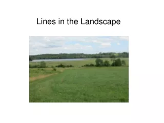
Lines in the Landscape. Wetland. WETLAND HYDROLOGY…water at or near soil surface, sufficient to influence vegetation and soil. HYDROPHYTIC VEGETATION = the community of plants that develops where inundation or saturation is “permanent or of sufficient duration to influence plant occurrence”.

E N D
Wetland WETLAND HYDROLOGY…water at or near soil surface, sufficient to influence vegetation and soil HYDROPHYTIC VEGETATION = the community of plants that develops where inundation or saturation is “permanent or of sufficient duration to influence plant occurrence” HYDRIC SOILS= is a soil that formed under conditions of saturation, flooding or ponding long enough during the growing season to develop anaerobic conditions in the surface soil (30cm)
HYDROPHYTES: “species that have demonstrated an ability to achieve maturity and reproduce in an environment where all or portions of the soil within the root zone become periodically or continually saturated or inundated during the growing season.” (Reed, P.B. 1988. US Fish and Wildlife Service) Atlantic White Cedar morphological adaptation: stilt roots
Plants are divided into: 1. Those only in UPLAND = UPLAND 2. Those only in WETLAND = OBLIGATE 3. Those that occur in wetlands or uplands... = FACULTATIVE wetland species
ExampleofOBLIGATE Sweet Gale, Myrica gale Where OBLIGATES or FACWETS dominate, vegetation is HYDROPHYTIC by “RAPID TEST” adventitious roots formed when woody stem are in water
THE CANADA HOLLY, Ilex verticillata FACW Canada Holly
Black spruce (FACW), red maple (FAC), and eastern hemlock (FACU) FACW FAC FACU
Three tests to demonstrate Hydrophytic Vegetation RAPID TEST 50:20 DOMINANCE TEST PREVALENCE TEST
TESTS FOR HYDROPHYTIC VEGETATION RAPID TEST Carex trisperma, cinnamon fern, black spruce, larch cottongrass, tussock sedge, black spruce, larch REQUIREMENT: THE COMMUNITY DOMINANTS ARE OBL OR FACW
DELINEATION occurs at the wetland edge where wetland and upland plants converge
50:20 Dominance Test Assesses dominance for three layers that are height based not plant type based For plant identification, we refer to plant habit as follows
Dominance test ignores botany and uses layers or strata TWO STRATA: Herbs and Trees THREE STRATA: Herbs, Shrubs and Trees
Divide Community into woody and non-woody plants HERBS are all herbaceous plants PLUS all woody plants under One Metre in height So blueberry and sheep laurel are considered herbs
Identify the Shrub stratum Shrubs are woody plants More than 1m in height But less than 8 cm in stem diameter at breast height (DBH at 1.4m)
50:20 TEST is carried out at points along the delineated line. Recommended that minimum of two points are assessed for large wetlands. Paired points should not be far from the flagged line. Each point is waypointed for reference
CIRCULAR PLOTS Herb Stratum = 1.5 m radius Shrub Stratum = 5m Tree Stratum = 10m note: Plots must make sense: Upland tree or shrub plot cannot go too near delineated line
Nova Scotian flora is rich in FACULTATIVE wetland plants Cold and wet springtime means many habitats are waterlogged early in the growing season For this reason, the Dominance, or 50/20, test may be of little use in much of Nova Scotian upland.
PREVALENCE INDEX USES • Standard Practice = a follow up test if the 50:20 is negative (ie. says veg not hydrophytic) • An Additional Test in cases where Dominants are all FAC but subordinates suggest Upland (FACU) or Wetland (FACW) tendencies (cf. Wakeley and Lichvar, 1997. Wetlands 17:301-309)
50:20 Insights 50:20 Ignores all non-dominants. Strata with 2 FACs at 30% each and 2 FACUs at 10% is scored as.. After 50:20 selects dominants, their relative abundances (e.g. 80% Huckleberry, 20% Labrador tea) are forgotten
Prevalence Index is a “weighted average” method. It applies a sliding weight, a factor, to the summed cover values of all plants in particular moisture classes (e.g. OBL, FACW, etc.). *All species having any cover are used in the calculation. Factors range from 1 for OBL to 5 for UPL The Products, B, (summed covers x factors) is divided by the sum of all plant cover values, A. If the Index is equal to or less than 3, the vegetation is HYDROPHYTIC
Site below has: 1 FACU, 5 FAC, and 1 FACW dominant. 6 species of a total of 7 =FAC or wetter, 6/7x100= 83%. Soil is a fibrous peat over granite but it is not a histosol (A1) No evidence of soil saturation. No hydrology indicators. Note Bracken and Jack pines (but dead so not used in calculation)
Morphological Adaptations Eastern Hemlock FACU Evidence of seasonal high water through site and long-term response of most hemlock by making STILT rooting systems Document that most trees show this THEN recalculate the 50/20 with hemlock as a FAC based on morphology
SHRUBS: Speckled Alder, Alnus incana Note in farming areas, alders will move into upland old fields
MORPHOLOGICAL ADAPTIONS in ALDER Indicating wetland conditions STILT ROOTS HYPERTROPHIED LENTICELS ←adventitious rooting
TUSSOCK VEGETATIONGRAMINOIDS & FERNS annual water fluctuation Carex stricta Fern understory: Carex leptalea finds drier feet on small cinnamon fern clumps
Sphagnum mosses Most require moisture and they can transform upland edge of bogs into wetland DELINEATOR’S FRIEND http://acwc.sdp.sirsi.net/client/search/asset/1001765
There will be confused signals..cinnamon and bracken BUT cinnamon should be FACW and bracken FACU Cinnamon fern Bracken and whenever in doubt..check soil