Download

1 / 37
370 likes | 396 Views
This presentation by Cecil Whaley Jr., Director of Planning, Training, and Exercises at the Tennessee Emergency Management Agency, highlights the risks and planning considerations for a potential catastrophic earthquake based on a New Madrid event. The session covers historical seismic activity in the area, potential impacts on populated regions like West Tennessee, and the projected extent of damage to critical facilities, transportation infrastructure, and utility lifelines. Key assumptions about the earthquake scenario are outlined, emphasizing the need for preparedness at the local, state, and federal levels. The discussion also references a HAZUS EQ Event Report by the University of Memphis CERI, detailing the projected effects on households, facilities, and lifelines in the event of a major earthquake. Stay informed and ready to respond in case of this high-risk natural disaster.

E N D
Catastrophic Earthquake Planning (Based on a New Madrid EQ Event) CECIL WHALEY JR. Director, Planning, Training, Exercises Tennessee Emergency Management Agency Tennessee Department of Transportation Highway Safety & Operations Conference Oct. 28, 2016
Situation • During the winter of 1811 & 1812, 4 of the most powerful earthquakes to strike the North American Continent occurred within the New Madrid Seismic Zone. • The area was sparsely populated, however, historical accounts said the great quakes, rang church bells in Boston and D.C.….., caused the Mississippi River to run backwards, etc….. • Scientist tell us this is an active fault system, hundreds of earthquakes occur annually. There is evidence of other great earthquakes within the New Madrid Seismic Zone. Study has shown that the New Madrid has a history of producing “cluster” quakes and a quake of a 6.0 or 7.0 magnitude is much more likely (40% chance in the next 50 years). • Wide portions of West Tennessee are located within the New Madrid Seismic Zone. • Much of the Mississippi River Valley is alluvial sediment subject to high liquefaction potential. • West Tennessee is now much more densely populated than in 1811-12 • There is a large number non-reinforced masonry structures within the region. • If major quake were to occur, effects could be far reaching.
The following is an abbreviated description of 6 levels of Modified Mercalli intensity. IV. Felt indoors by many, outdoors by few during the day. At night, some awakened. Dishes, windows, doors disturbed; walls make cracking sound. Sensation like heavy truck striking building. Standing motor cars rocked noticeably. V. Felt by nearly everyone; many awakened. Some dishes, windows broken. Unstable objects overturned. Pendulum clocks may stop. VI. Felt by all, many frightened. Some heavy furniture moved; a few instances of fallen plaster. Damage slight. VII. Damage negligible in buildings of good design and construction; slight to moderate in well-built ordinary structures; considerable damage in poorly built or badly designed structures; some chimneys broken. VIII. Damage slight in specially designed structures; considerable damage in ordinary substantial buildings with partial collapse. Damage great in poorly built structures. Fall of chimneys, factory stacks, columns, monuments, walls. Heavy furniture overturned. IX. Damage considerable in specially designed structures; well-designed frame structures thrown out of plumb. Damage great in substantial buildings, with partial collapse. Buildings shifted off foundations.
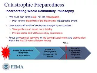
Assumptions • The earthquake will strike without warning. • An earthquake could cause many casualties, damage to a large number of structures and result in disruption to government services, transportation, essential services and needed lifelines. • Damaging aftershocks will occur within minutes, days, or months following the main event. • Major pipelines and fuel storage facilities will fail • As with all emergencies and disasters, it occurs on the local level and local government will be the first response to the disaster. • Citizens should be prepared to be on their own for 72 + hours. • Response to the New Madrid event will be top priority within all government entities: Local, State and Federal.
HAZUS EQ Event Reportby U of M CERI • Sw probabilistic scenario, M 7.7 • 12 Counties included in the report • 6,288 sq mi • 488,000 households • Critical Facilities • Essential Facilities- hospitals, medical clinics, schools, fire stations, police stations and EOCs. • High potential loss facilities- dams, levees, military installations, nuclear power plants, Hazmat sites. • Transportation & Utility Lifeline • Transportation- 7 Systems, highways (3,407 k)(1,244 bridges), railways, light rail, bus, ports, ferry and airports. • Utility Lifeline- potable water, wastewater, natural gas (54,153 K pipeline), crude & refined oil, electrical power and communications.
HAZUS REPORT 1,291,500 210,600 Obion Lake Weakley Henry Dyer Benton Gibson Carroll Crockett Lauderdale Henderson Haywood Madison Tipton Decatur Chester Fayette Hardeman Shelby McNairy Hardin
Damage Expected • Buildings – 105,127 at least moderately damaged. • Buildings beyond repair- 14,973 • Hospitals – 5,699 hospital bed available pre EQ, about 22.0% are available for use post EQ. • Schools – 457 damaged (22 >50%) • EOC – 8 damaged • Police Stations – 99 damaged (12 functionality >50%) • Fire Stations – 87 damaged (15 >50%) • Highway – 749 segments 50% functional after day 1. • Bridges – 1,244; 240 with damage, 25 complete. • Airport Runways – 43 total, 43 ( functionality >50%)
Damage Expected • Potable Water – 27,077 kms, 16,194 leaks,4048 breaks. • Waste Water – 16,246 kms, 12,808 leaks, 3202 breaks. • Natural Gas – 10,831 kms, 13,691 leaks, 3432 breaks. • 488,708 households – • Potable water – 192,785 without service at Day 1 • Electrical Power – 255,796 without service at D 1
Damages & Casualties • The nature and magnitude of damages and casualties will depend on the following factors: • Magnitude of the earthquake • Time of day • Location of the epicenter • Construction practices • Soil conditions • Duration of the earthquake • A repeat of the 1811 and 1812 quakes could inflict thousands of casualties in the Memphis area and hundreds to thousands within the West Tennessee Region.
Earthquake Planning History • 1984 – Tennessee becomes charter member of CUSEC • 1989 – CUSEC relocates to Memphis TN • Nov. 89 - West Tennessee Region EQ Plan • Dec. 89 – State of Tennessee Tabletop Ex • Apr. 90 – Distributes Guidance Document for Tennessee EQ Program “actions” • Aug. 90 - FEMA distributes revised “Official Fed Plan for response and recovery (ESF) • Oct. 90 - TEMA conducts major Tabletop Ex involving State agencies and high risk counties in West TN. • Oct. 90 - TEMA completes and distributes State Earthquake Plan • Oct. 90 - TEMA conducts training and orientation sessions on plan (meetings – video conferencing) • Nov. 90 - State and Federal joint EQ Ex in Nashville (local participation, Memphis & Shelby County) • 1990 – Counties began development of Local County EQ Plan based on State Guidance • Aug. 95 – West TN Region up-dated Regional EQ Plan • 1997 – State participates is “CAT 97” EQ Ex hosted by FEMA held in Little Rock. • Oct. 00 – West TN Region wide functional EX, West TN Counties and selected Middle TN Counties. • 2000 – TDOT joins CUSEC 7 state Transportation Task Force • 2000 – State Geologist • Mar. 01 – West Region participated in 1st US Army functional EQ EX, Jackson. • 2004 – Local EMD participation in 1st US Army functional EQ Ex. Atlanta • 2004 – All West TN counties up-dates All Hazards BEOP to ESF format • 2005 – West TN Region up-dated Regional EQ Plan to include NIMS. • Annual - TEMP revisions/up-dates
County Information • Potential Shelter locations • Staging Area Locations • Casualty Collection Points • Potential Relocation Areas • Evacuation Routes • Communications Capabilities/shortfalls • County/City Assets
Coordination Matrix SEOC Local EOC REOC Command to EOC Branch to Section Unit to Branch TF to Unit ST to TF
ESF 1 - Transportation • Lead: TDOT • Support: Military, Safety, Tourism • Concept • Coordinate traffic into and out of affected area, traffic flow by emergency responders • Assess TDOT Facilities and equipment • Assess traffic routes, roads, bridges • Make repairs necessary to facilitate emergency traffic • County Maintenance Garage will assess their area and make report to District Office. • District Office will accumulate and evaluate assessment and pass to Regional Office for submittal to Regional ESL. • Regional ESL will provide information to REOC and ESC at SEOC. • TDOT personnel will report to nearest TDOT facility and then attempt to report to regular duty station. • Equipment will be staged if possible to District Garage Compounds. • Outside TDOT Regional Assets will be staged at the Regional Compound. • Some fuel capability is maintained at the District and Regional Garage Level
Potential Response Routes 79 54 641 Probable response routes From Nashville to Jackson 70 I 40 69 412 Probable alternate Routes to Memphis Alternate routes To Jackson 22 64 57 72
ESF 6 – Human Services • Sheltering & Care Service: reception, processing, provisioning, lodging, protection, and support of people who are displaced from their homes and normal living patterns by the threat or occurrence of a disaster. • HAZUS – estimates 19,183 households displaced by the Eq, of these, 5,553 will seek temporary shelter in public shelters the first 24 hours, could reach 200,000 by 72 hours.
Sheltering • Comfort Stations- A location where affected individuals and responders may receive food, water, and other needed items on an immediate and temporary basis. • Short Term (Emergency) Shelters – short time period where affected individuals either may be able to return to their homes in a relative short period of time or moved to longer term housing. • Long Term Shelters – provided for longer periods when there is no housing available or there is no indication of when they will return to their homes. • Temporary Housing – housing furnished for a short period of time, motel, school dorms, apartments, etc. • Long Term Housing – furnished for those that may have completely lost their home or have major damage and cannot return for an extended period of time. • Shelter-in-place, used to shield residence from negative effects of the environment or hazardous situations.
ESF 6 - Sheltering Concept • Address Locally – 25 sq per person. • Schools • Churches • Large Buildings • Community Centers • Motels and rental and FHA/VA homes • Open Areas for Tents or Emergency Shelter Sites.
Sheltering • Proposal: Provide emergency food, water, temporary sheltering, medical assistance and information/communications abilities for 20,000 civilians in Shelby, Tipton, Lauderdale, Dyer, Lake and Obion Counties (High Impact Counties) for the first 24 hour period. • Possible 200,000 by 72 hours.
Sheltering • Basic Assumption: Surge temporary sheltering is identified in local BEOP. • Division of population-by age 60% adult, 20% elderly, 20% children with normal medical needs and no survival capabilities.
Feeding/Water • Basic Assumption: Average adult needs 5 gals. of water daily for drinking and minor sanitation. A child 3 gals. daily. • 16,000 adults require 50,000 gal of water daily • 4,000 children require 10,000 gal of water daily • Appx – 60,000 gallon of water daily • Food, 1,000,000 meals needed per day • Appx – 300,000 units for nutritional coverage • Shelf ready food could be stored in inter-modal • With back-up warehoused in rear staging (for easier rotation and inventory)
Temporary Emergency Shelter • Basic Tent (Western Shelter) 19X35 • Capable of sleeping up to 20 persons. • Storage containers, portable, shower and toilet facilities, insulation, heat and air systems, lighting, flooring etc. • System – $51,000 per unit.
Push-Packs • Emergency Supplies; cots, blankets, sheets, personal hygiene supplies, medical dry goods, shelf ready food. • Dry goods stored in inter-modal containers • 20 or 40 foot. • Storage at State facilities, NG Armory, TDOT Facilities, THP Districts, Health Department Facilities.
ESF 8 Estimated Casualties • HAZUS – • Level 1: require med attention, not hospitalization. • Level 2: require hosp but not life-threatening • Level 3: require hosp and become life threatening if not promptly treated. • Level 4: Victims killed by the eq. Also estimates were provided for 3 times.
CASUALTY ESTIMATES Level 1 2 3 4 2 AM 6,850 1,793 253 492 2PM 11,051 3,119 484 920 5PM 9,004 2,621 622 764
ESF 7 - Primary Staging • Large paved, packed rock, secure sites that will accommodate multiple heavy trucks (100+) and other heavy equipment, fueling and maintenance for same, rehab capabilities for operators. Should be near to strong landing sites/strip for fixed wing aircraft. • Example: State Parks, municipal parks, athletic fields. • Used to register, type, identify and assign to forward staging up-on request.
Potential Staging Airports Paris Landing Potential Rear LSA Reelfoot Park A3500 Everett-Stewart A5000-2000 Potential Forward Staging Paris A5000-2500 Response Logistics Check-in Dyersburg A5000 Carroll A5000 Camden A35000 Gibson Co A4000 Milan A4800 Humboldt A4000 Humboldt A4000 MTC Halls C4700 Natchez Trace Franklin-Wilkins A45000 Covington A5000 Parsons A4000 McKellar-Sipes A6000-3500 Millington Jet Port C8000 Chickasaw Chas Baker A3500-1600 Fayette Co A3500 Boliver A4000 Selmer A4300 Pickwick Savannah A5000 MEM C8900-9600-10000,, 11000
Forward Staging • Sites closer to individual command sites • Sites should be secure • Local airports, Fair grounds, parking lots, etc.
Shelby County Potential Staging Air Staging 10 13 5 17 12 16 1 15 18
ESF 5 Intelligence • Rapid Impact Assessment must have equal priority among the emergency services. Local/State and Federal officials neel some idea of the current situation a “snapshot” of the situation in order to begin and coordinate response efforts.
Old Medina I-40 Airways Beach Bluff Hwy 18
Primary North, South East and West Routes 4 lane hwy 1500 per hr per lane 2 lane hwy 1000 per hr per lane Primary North South Routes I 40 51 54 Primary East West Routes 14 64 I 55 72
Economic Loss Estimation • Building (direct and interruption) • Total $100 Billion • 15% estimated business interruption loss • 55% of the total loss was residential • Utility System • Inventory $6 Billion • Economic loss $16 Billion loss of revenue • First year employment impact – 56,716 m
Summary of Planning Initiative • Basic Annex Draft revised • 60 meeting have been conducted with Local, State, Federal and Volunteer Agencies. • Gathering response capabilities, inventory of resources and needs list. • Identifying communications problems and possible solutions. • Attempting to address food, water, shelter, fuel, medical, storage, comfort stations, push paks. • Developing inventory of transportation assets in Region. • Developing inventory of Emergency Response Equipment • Collecting information from each County: • Shelter Locations - CCPs • Staging Areas - Evacuation Routes • Potential relocation areas - Commo capability and problems • Local assets/capabilities - Economic data