Download
1 / 15
150 likes | 231 Views
Learn how Washington State DOT utilizes GIS technology to pinpoint collision locations, streamline processes, and boost safety on public roadways. Explore the development of an Incident Location Tool and its impact on data accuracy and efficiency.

E N D
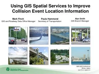
Using GIS Spatial Services to Improve Collision Event Location Information Mark Finch GIS and Roadway Data Office Manager Paula Hammond Secretary of Transportation Alan Smith GIS Branch Manager NW GIS Conference Boise, Idaho 10/17/11-10/21/11
Introduction The Washington State Department of Transportation is responsible for establishing the locations of all collisions that take place on all public roadways in Washington State. Our success depends on how well we apply our limited funding to most effectively improve safety. We need to know where collisions are taking place and what’s causing the collisions. WSDOT processes approximately 100,000 collision reports from 272 law enforcement agencies each year. Collisions reports are converted to data elements and entered into a database. The collision data is provided to Department of Licensing and to state law enforcement agencies. For several years, WSDOT has used GIS to map collision events that occur on state routes in order to focus highway system improvements dollars. NW GIS Conference Boise, Idaho 10/17/11-10/21/11 2
Collision Analysis Map NW GIS Conference Boise, Idaho 10/17/11-10/21/11 3
Old Business Process • Collision reports are submitted on paper and digitally • Collision reports elements are entered into a database • Collision reports include a wide variety of “location information” • Street Address • Route Number and Measure along a Route • Intersection • Common Place Name • Measurement from any of the Above • Jurisdictional Analysts and Collision Coders read each collision report and use a paper or computer based map products in order to establish jurisdiction and a general location for a collision NW GIS Conference Boise, Idaho 10/17/11-10/21/11 4
Old Business Process Continued…. Final collision data records include minimal location information and only collisions on state routes can be mapped with any degree of accuracy by state route milepost • Of the 100,000 reports that are processed each year on over 80,000 miles of public roadways • 10,000 are returned to law enforcement agencies for further clarification • 9,000 of which have problems with locations NW GIS Conference Boise, Idaho 10/17/11-10/21/11 5
Business Case Request • Budget request was submitted to the Washington State Legislature in the 09-11 biennium to develop a system for improving the business process for locating collisions • Washington State Legislature allocated $150,000 for hardware, software, data and application development • Business requested a quick and easy to use interactive mapping solution that would use consistent, authoritative data and streamline collision location. • The project took 6 months to complete at a total cost of $110,000 NW GIS Conference Boise, Idaho 10/17/11-10/21/11 6
High Level System Requirements • Replace the wide variety of non-authoritative map resources with a single interactive mapping application • Deliver significant efficiency to the existing process and eliminate the jurisdictional analysis step • The application must use GIS to provide each collision record with the X/Y coordinate, Primary Trafficway, Milepost, Block Number, Secondary Trafficway, Distance from Reference and Direction from Reference • Integrate with existing systems and business processes • Employ consistent and authoritative data and tools for collision event location and for spatial queries • The application must be intuitive, easy to use and quick NW GIS Conference Boise, Idaho 10/17/11-10/21/11 7
Solution – A Map-Based Workflow Enhancement System Incident Location Tool (ILT) • Improves efficiency in the business process • Improves accuracy and precision • Improved data consistency • Interface with Collision Location Analysis System (CLAS) and eventually Statewide Electronic Collision and Ticketing Online Record (SECTOR) NW GIS Conference Boise, Idaho 10/17/11-10/21/11 8
Development of Incident Location Tool • We did not build an application that met functional requirements, we built services that were capable of meeting the functional requirements • We then built a client application that makes use of the services • Resulted in a new system that is highly modular • Using a robust set of geoprocessing and cartographic services, its capable of supporting various client applications. • The client applications can be browser based, mobile, lightweight desktop, heavy desktop or other server based clients. • Easy to update/replace and deploy any of the services. • The current production ILT client is a lightweight desktop application that is integrated with an existing system NW GIS Conference Boise, Idaho 10/17/11-10/21/11 9
Incident Location Tool Major Components • ILT User Control – Uses C# code and provides the map and user interface functionality • Host Control – This is the container that runs the ILT control. The host control will continue to have the ability to pass and receive data with the CLAS Services • Web Services – City Catalog, CountyCatalog, StateRouteCatalog • Geoprocessing Services – Location information, XY, State Route Milepost (SRMP), GetNearestCity • Geocoding Sevices – Address Locator (also SRMP, Intersection, city, County NW GIS Conference Boise, Idaho 10/17/11-10/21/11 10
Incident Location Tool Major Components Continued.. • Measure Service – Custom measure tool • Base Map Service (cached) – Orthos, local roads, State Routes, etc. • City Limits Map Service (dynamic) – City limits polygons • Road Labels Services (dynamic) – Annotation NW GIS Conference Boise, Idaho 10/17/11-10/21/11 11
New Business Process • Collision reports are submitted on paper/digitally • Collision location elements are entered into a database • A new GIS application geocodes and maps all usable location elements • The collision coder uses the interactive GIS application to establish an accurate location • The GIS application queries map layers and automatically populates several database fields, other fields are still manually entered • Final collision data records include all of the provided location information and an X,Y location NW GIS Conference Boise, Idaho 10/17/11-10/21/11 12
Benefits of the Incident Location Tool • Reduction in data entry time • The process of establishing location is faster and more accurate • Reduced number of collisions that sent back to officers for corrections • All collisions are researched and located using consistent maps and tools • Statewide collision data will be available for mapping and analysis, because they now include X,Y • All of the server side geospatial services, cartographic and geoprocessing are available for other applications to use • The services based architecture makes it easy to update geoprocessing and cartographic components with minimal disruption NW GIS Conference Boise, Idaho 10/17/11-10/21/11 13
Next Steps – Integration of the ILT Map into SECTOR Benefits: • The ILT will integrate with existing GPS receivers, helping officers to locate the event • The ILT’s interactive map will provide officers with all of the core map layers and tools • Once the Officer has established a location, with a simple map click, the ILT will pre-populate several of the data fields in SECTOR, saving the office time and allowing for faster collision site clearing • When the ILT enabled collision reports reach WSDOT for coding, they will already have an X/Y location, this completely eliminates the need for post processing of location NW GIS Conference Boise, Idaho 10/17/11-10/21/11 14
Contacts Mark Finch Washington State Department of Transportation Strategic Planning Division GIS and Roadway Data Office Manager Finchm@wsdot.wa.gov 360-570-2369 Alan Smith Washington State Department of Transportation Strategic Planning Division GIS Branch Manager Smitha@wsdot.wa.gov 360-596-8925 NW GIS Conference Boise, Idaho 10/17/11-10/21/11 15