Download
1 / 34
340 likes | 361 Views
This paper discusses the SERVO Grid, a collection of web services for analyzing faults and predicting seismic activity. The services utilize geospatial data, implement GIS standards, and support streaming data. The paper also explores metadata and information services, as well as service orchestration using HPSearch.

E N D
Community Grids LabSERVOGrid CCE ReviewMay 11 2005 Geoffrey Fox and Marlon Pierce Indiana University
SERVO Apps and Their Data • As summarized below, many SERVO codes use observational data measurements as input and create geo-located results. • Disloc: handles multiple arbitrarily dipping dislocations (faults) in an elastic half-space. • Relies upon geometric fault models. • GeoFEST: Three-dimensional viscoelastic finite element model for calculating nodal displacements and tractions. Allows for realistic fault geometry and characteristics, material properties, and body forces. • Relies upon fault models with geometric and material properties. • Virtual California: Program to simulate interactions between vertical strike-slip faults using an elastic layer over a viscoelastic half-space. • Relies upon fault and fault friction models. • Pattern Informatics: Calculates regions of enhanced probability for future seismic activity based on the seismic record of the region • Uses seismic data archives • RDAHMM: Time series analysis program based on Hidden Markov Modeling. Produces feature vectors and probabilities for transitioning from one class to another. • Used to analyze GPS and seismic catalogs.
Our Approach to Building Grid Services • There are several competing visions for Grid Web Services. • WSRF (US) and WS-I+ (UK) are most prominent • We follow the WS-I+ approach • Build services on proven basic standards (WSDL, SOAP, UDDI) • Expand this core as necessary • GIS standards implemented as Web Services • Service orchestration, lightweight metadata management • We stress innovative implementations • Web Services are essentially message-based. • SERVO applications require non-trivial data management (both archives and real-time streams). • We can support both streams and events through NaradaBrokering messaging middleware. • HPSearch uses, manages NaradaBrokering events and data streams for service orchestration. • Upcoming improvements to the Web Feature Service will be based on streaming to improve performance. • Sensor Grid work is being based on NaradaBrokering. • Core NaradaBrokering development stresses the support for Web Service standards • WS-Reliability, WS-Eventing, WS-Security • Not directly funded by AIST but will make its way into AIST work.
Geographical Information System Services as a Data Grid • We decided that the Data Grid components of SERVO is best implemented using standard GIS services. • Use Open Geospatial Consortium standards • Maximize reusability in future SERVO projects • Provide downloadable GIS software to the community as a side effect of SERVO research. • We implemented two cornerstone standards • Web Feature Service (WFS): data service for storing abstract map features • Supports queries • Faults, GPS, seismic records • Web Map Service (WMS): generate interactive maps from WFS’s and other WMS’s. • Maps are overlays • Can also extract features (faults, seismic events, etc) from user GUIs to drive problems such as the PI code and (in near future) GeoFEST, VC. • We built these as Web Services • WSDL and SOAP: programming interfaces and messaging formats • You can work with the data and map services through programming APIs as well as browser interfaces. • Running demos and downloadable code are available from www.crisisgrid.org. • We are currently working on these steps • Improving WFS performance • Integrating WMS clients with more applications • Making WMS clients publicly available and downloadable (as portlets). • Implementing SensorML for streaming, real-time data.
Metadata and Information Services Work • We like the OGC but their metadata and information services are too specialized to GIS data. • Web Service standards should be used instead • For basic information services, we developed an enhanced UDDI • UDDI provides registry for service URLs and queryable metadata. • We extended its data model to include GIS capabilities.xml files. • You can query capabilities of services. • We added leasing to services • Clean up obsolete entries when the lease expires. • We are also implementing WS-Context • Store and manage short-lived metadata and state information • Store “personalized” metadata for specific users and groups • Used to manage shared state information in distributed applications • See “Performance Analysis” slides for more information • See http://grids.ucs.indiana.edu/~maktas/fthpis/
Service Orchestration with HPSearch • GIS data services, code execution services, and information services need to be connected into specific aggregate application services. • HPSearch: CGL’s project to implement service management • Uses NaradaBrokering to manage events and stream-based data flow • HPSearch and SERVO applications • We have integrated this with RDAHMM and Pattern Informatics • These are “classic” workflow chains • UC-Davis has re-designed the Manna code to use HPSearch for distributed worker management as a prototype. • More interesting work will be to integrate HPSearch with VC. • This is described in greater detail in the performance analysis presentation and related documents. • See also supplemental slides.
Summer Vacation • Integrate HPSearch with Virtual California for loosely coupled grid application parameter space study. • HPSearch is designed to handle, manage multiple loosely coupled processes communicating with millisecond or longer latencies. • Improve performance of data services • This is the current bottleneck • GIS data services have problems when you do non-trivial data transfers • But streaming approaches and data/control channel separation can dramatically improve this. • Provide support for higher level data products and federated data storage • CGL does not try to resolve format issues in different data providers • See backup slides for a list for GPS and seismic events. • GML is not enough • USC’s Ontronic system researches these issues. • Provide real time data access to GPS and other sources • Implement SensorML over NaradaBrokering messaging • Do preliminary integration with RDAHMM • Improve WMS clients to support sophisticated visualization
NaradaBrokeringManaging Streams • NaradaBrokering • Messaging infrastructure for collaboration, peer-to-peer and Grid applications • Implements high-performance protocols (message transit time of 1 to 2 ms per hop) • Order-preserving, optimized message transport with QoS and security profiles for sent and received messages • Support for different underlying protocols such as TCP, UDP, Multicast, RTP • Discovery Service to locate nearest brokers
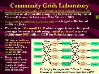
HPSearch and NaradaBrokering • HPSearch uses NaradaBrokering to route data streams • Each stream is represented by a topic name • Components subscribe / publish to specified topic • The WSProxy component automatically maps topics to Input / Output streams • Each write (byte[] buffer) and byte[] read() call is mapped to a NaradaBrokering event
Where Is the Data? • QuakeTables Fault Database • SERVO’s fault repository for California. • Compatible with GeoFEST, Disloc, and VirtualCalifornia • http://infogroup.usc.edu:8080/public.html • GPS Data sources and formats (RDAHMM and others). • JPL: ftp://sideshow.jpl.nasa.gov/pub/mbh • SOPAC: ftp://garner.ucsd.edu/pub/timeseries • USGS: http://pasadena.wr.usgs.gov/scign/Analysis/plotdata/ • Seismic Event Data (RDAHMM and others) • SCSN: http://www.scec.org/ftp/catalogs/SCSN • SCEDC: http://www.scecd.scec.org/ftp/catalogs/SCEC_DC • Dinger-Shearer: http://www.scecdc.org/ftp/catalogs/dinger-shearer/dinger-shearer.catalog • Haukkson: http://www.scecdc.scec.org/ftp/catalogs/hauksson/Socal • This is the raw material for our data services in SERVO
WFS by the Numbers • The following data is available in the SERVO Web Feature Services • These were collected from public sites • We have reformatted to GML • Data • Filtered GPS archive (297 stations) from : 48.02MB • Point GPS archive (766 stations): 42.94MB • SCEDC Seismic archive: 34.83MB • SCSN Seismic archive: 26.34MB • California Faults (from QuakeTables Fault DB): 62KB • CA Fault Segments (from QuakeTables Fault DB): 41KB • Boundaries of major European Cities: 12.7KB • European map data: 636KB • Global Seismic Events:14.8MB • US Rivers: 11KB • US Map-State Borders: 1.13MB • US State Capitals:5.75KB • WFS URLs • http://gf1.ucs.indiana.edu:7474/axis/services/wfs?wsdl • http://gf1.ucs.indiana.edu:7474/wfs/testwfs.jsp
HPSearch Kernel HPSearch Kernel WSProxy WSProxy WSProxy Service Service Service Request Handler Request Handler Java script Shell URIHandler Task Scheduler Flow Handler Broker Network DBHandler Web Service EP WSDLHandler WSProxyHandler Other Objects HPSearchArchitecture Diagram Files Sockets Topics Network Protocol DataBase JDBC Web Service SOAP/HTTP SOAP/HTTP HPSearch Control Events usingPUB/SUB on predefined topic Data buffers sent / received as Narada Events . . . HPSearch Kernel
HPSearch (TRex) HPSearch (Danube) Actual Data flow HPSearch controls the Web services Final Output pulled by the WMS HPSearch Engines communicate using NB Messaging infrastructure Data can be stored and retrieved from the 3rd part repository (Context Service) WS Context (Tambora) GPS Database (Gridfarm001) NaradaBroker network: Used by HPSearch engines as well as for data transfer WMS Data Filter (Danube) Virtual Data flow WMS submits script execution request (URI of script, parameters) HPSearch hosts an AXIS service for remote deployment of scripts • PI Code Runner • (Danube) • Accumulate Data • Run PI Code • Create Graph • Convert RAW -> GML GML (Danube)
Collaborations with SCIGN (Aydin) • Installed NaradaBrokering node • Can be used to manage multiple streams using topic-based publish/subscribe techniques • Uses chains of publishers and subscribers to • Deliver binary RYO data directly to subscribing clients, OR • Deliver RYO to Text translators that publish to interested clients, OR • Deliver RYO text to GML translators, for delivery to interested clients • Used topic-based stream organization • RYO binary format on SOPAC/GPS/Positions/XXX/RYO • Text processed RYO messages available on SOPAC/GPS/Positions/XXX/Text • XXX is the location of the station (San Diego, Riverside) • Full report available from here • http://complexity.ucs.indiana.edu/~gaydin/sopac/summary.doc • Sample code is in the same directory
In Development: SensorML • CGL has great deal of experience with building software to support audio/video streams. • Code, lessons learned can be applied to real time data GPS data streams. • We are collaborating with Scripps to build a Sensor Grid • Based on OGC’s SensorML family of specifications • SensorML specification funded by NASA AIST • This will allow us to build real-time support for SERVO • RDAHMM is an excellent candidate • We also have interesting approaches for handling the streams and implementing SensorML. • This work is just underway • We only preview it here.
GPSNETWORK RYO Message Java socket 7010 Raw Data NB Publisher Java socket 7011 GPSNETWORK RYO Message NB Publisher Common Link Proxy RYO/1 NB Subscriber NB Subscriber RYO Text RYO/2 Positions/Text/1 NB Publisher NB Publisher Text Positions/Text/2 GML Positions/GML/1 Positions/GML/2 RYO Decoder GML Converter Narada Broker
SensorML and NaradaBrokering • Common Link Proxy: this is provided by SCIGN. • We connect to these sockets, grab the data, and publish it. • NaradaBroker: this is the publish/subscribe manager node. • The enclosed squares (RYO/1, Positions/Text/1, etc) are topics. • RYO Decoder: this translates RYO binary to text. • Subscribes to binary stream • Publishes back to the Text topics. • GML Converter: translates text to GML • Subscribes to Text stream topics • Publishes on GML stream topics
Community Grids and the Grid Community • Geoffrey Fox • Global Grid Forum • Acting leader of the GGF Community Council • Member of the Grid Forum Steering Group • Co-leader of the Grid Computing Environments and Semantic Grid Research Groups • UK e-Science Advisory Group Member • Open Middleware Infrastructure Institute (OMII) Advisory Member • Los Alamos D Division Advisory Board • Sensors, decision support systems, GIS Grids • Marlon Pierce • Secretary of the GGF Semantic Grid Working Group • Party whip for the Grid Computing Environments Working Group
Who Does What? • Galip Aydin: WFS and SensorML • Harshawardhan Gadgil: HPSearch • Ahmet Sayar: WMS • Mehmet Aktas: WS-Context and UDDI