Download
1 / 43
430 likes | 455 Views
Susan questions shrimp sourcing at Captain Joe's, leading to revelations of shrimp disappearance in local waters linked to pollution. Join her investigation into shrimp depletion causes in the Gulf of Mexico.

E N D
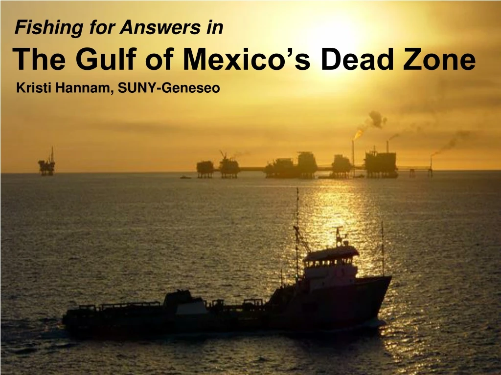
Fishing for Answers in The Gulf of Mexico’s Dead Zone Kristi Hannam, SUNY-Geneseo
Summer at the Seafood Shack Susan had moved in with Aunt Janet in Louisiana for the summer. She wanted to enjoy the sun and the beach, and save some money for college next fall. A week ago, she found a job as a waitress at Captain Joe’s Seafood Shack. At lunch, a businessman asked: “Where’s the shrimp from anyway?” She’d been asked this twice before already, so she knew the answer. “From Thailand.”
Next Morning The next morning, Susan and Aunt Janet were eating breakfast while watching boats on the Gulf. Aunt Janet pointed. “See that boat with the funny stuff sticking out the back? That’s George. He’s a shrimper.” “A shrimper? Then why does Captain Joe buy shrimp from Thailand?” “I don’t know, who don’t you ask him!”
Business Decision Captain Joe was busily setting up lunchtime plates when Susan found him. “If there are shrimp in the Gulf, why do you buy shrimp from Thailand, Captain Joe?” He stared at her, annoyed by the interruption. “Too expensive!” he grunted.
Front Porch Chat At Aunt Janet’s that evening, Susan found her aunt sitting on the front porch talking to George. After introducing herself, Susan asked him, “Is Captain Joe’s the only restaurant around here that doesn’t serve local shrimp?”
Shrimp Farms “Definitely not,” George said in reply to Susan’s question. “Most of the area right off the coast here isn’t good for fishing or shrimping anymore. Restaurant owners can get cheaper shrimp from farms in Asia or South America,” he added.
CQ#1: What do YOU think might be the reason why shrimp have disappeared from local waters? • Overfishing has depleted shrimp populations. • Pollution has killed off shrimp populations. • Rising water temperatures caused by climate change have made the habitat inhospitable to shrimp. • Hurricane Katrina destroyed all the shrimp and their habitat.
Dead Zone George continued: “People around here have a lot of different ideas about why shrimp are going away. Some think hurricanes like Katrina are to blame, others think overfishing, pollution, or climate change are the cause. I don’t know for sure, but something has definitely happened – people are calling our part of the Gulf a Dead Zone – and it seems to be growing every year.” 8
The four working hypotheses for the Dead Zone are: • Hurricane Katrina • Pollution • Climate change • Overfishing Can you think of other hypotheses?
What does this graph tell you about theaverage shrimp catch over time?
CQ#2: Which hypothesis does this graph NOT support? A. Hurricane Katrina B. Pollution C. Climate Change D. Overfishing
The four working hypotheses for the Dead Zone: • Hurricane Katrina • Pollution • Climate Change • Overfishing
Watching the local news that night, Susan saw an image of the Gulf Coast at the mouth of the Mississippi River that caught her attention: Source: NASA Earth Observatory
CQ#3: Which hypothesis does the evidence in this image support? A. Hurricane Katrina B. Pollution C. Climate Change D. Overfishing
Of her original hypotheses, Susan decided the evidence suggests she should explore the pollution hypothesis: • Hurricane Katrina • Pollution • Climate Change • Overfishing
Susan decided to investigate the sediment plume to see if there was a link to the disappearing shrimp in the Dead Zone. Her research revealed the following map: Watersheds of the Mississippi River Basin Source: USGS Fact Sheet 016-00
Susan realized that runoff from an enormous area could be causing the sediment plume. BUT: • The SIZE of the Mississippi River watershed probably hasn’t changed in thousands of years. • People have been shrimping and fishing in the Gulf for over 100 years. So WHAT could be causing the problem now? Source: USGS Fact Sheet 016-00
What does this figure tell you about the runoff to the Mississippi River basin over time? Source: USGS Fact Sheet 135–00
What does this figure tell you about the runoff to the Mississippi River basin over time? Source: USGS Fact Sheet 135–00
CQ#4: What do these figures tell you about the runoff to the Mississippi River basin over time? • Annual nitrate concentrations have increased over time. • Stream flow has remained constant over time. • The biggest source of nitrates is the area farthest from the Gulf of Mexico. • Only A and C. • A, B, and C are true.
Susan recalled a figure from her biology course http://serc.carleton.edu/images/microbelife/microbservatories/northinlet/Nitrogen_Cycle
CQ#5: What is the most likely source of nitrogen in runoff? • Fossil fuel emissions. • Organic matter. • Leaching of nitrates from nitrification. • Fertilizer runoff.
Susan realized that her Internet research had distracted her from her original question about shrimp. How could increased nitrates be connected to decreased fish and shrimp populations? She had figured out this much:Nitrates flow into the Gulf of Mexico from the Mississippi River watershed (especially states further north).The nitrates are carried by the freshwater river into the saltwater Gulf of Mexico. Susan’s Question
Interior Watersheds of the Mississippi River Basin • Largest river basin in North America. • Third largest basin in the world. • Includes 70 million people, 30 states. • One of the most productive farming regions in the world: • ~60% of the basin is cropland • ( corn, soybeans, wheat) • ~20% woodland, • ~20% barren land, • ~2% wetland, and • ~ 0.6% urban land • (Goolsby and Battaglin, 2000 ) Source: USGS Fact Sheet 016-00
CQ#6: When the freshwater river flows into the saltwater Gulf, what do you predict will happen? • The freshwater and the saltwater will mix, lowering the overall salinity of the Gulf. • The warmer freshwater will sink to the bottom of the Gulf, and the colder saltwater will float above. • The less dense freshwater will float on top of the more dense saltwater. • The amount of freshwater entering the Gulf is so small compared to the total volume of the Gulf that there will be no noticeable effect of the freshwater input.
Temperature & Salinity Layering • Video of temp & salinity experiments http://www.smm.org/deadzone/activities/top.html • Video of what happens in the Gulf http://www.smm.org/deadzone/causes/dead-zone.html
What Happens Next? • Excess nitrogen and more sunlight in surface waters leads to algae blooms. • The algae bloom provides food for zooplankton such as copepods. • Copepod wastes and dead algae sink to the bottom of the Gulf and decomposition lowers oxygen levels. • Continuing decomposition by bacteria lowers oxygen levels even more. Source: http://www.epa.gov/msbasin/taskforce/hypoxia.htm
Eutrophication leads to hypoxia in the benthic waters of the Gulf • Normal oxygen levels: ~ 4.8 mg/L • Hypoxia: < 2-3 mg/L • Anoxia: 0 mg/L
Stratification and Hypoxia Source: http://www.eco-check.org/forecast/chesapeake/methods/
Is there evidence of hypoxia in the Gulf of Mexico? Bottom-Water Dissolved Oxygen 18-23 July 2009 Data Data source: N.N. Rabalais, Louisiana Universities Marine Consortium, R.E. Turner, Louisiana State University Funded by: NOAA, Center for Sponsored Coastal Ocean Research
5-yr average goal n.d. Data source: N.N. Rabalais, Louisiana Universities Marine Consortium, R.E. Turner, Louisiana State University Funded by: NOAA, Center for Sponsored Coastal Ocean Research
Yes No CQ#7: Does the evidence you’ve seen so far mean that climate change and overfishing are NOT to blame for the decline of the shrimp fishery?
Responsibility Upon figuring this all out, Susan was quite upset. She was amazed that farmers in the Midwest might be to blame for the lack of shrimp in the water off the Louisiana coast.
Suppose you are on a government panel studying the Dead Zone problem. What recommendations would you make for solving the problem of the Dead Zone?Who should be responsible for fixing the problem, and what actions should they take?
Cooperative work by universities, state and federal agencies have come up with the following recommendations: • Make a watershed-wide plan. • Restore millions of riverside wetland and forest acres at a cost of billions of dollars. • Establish a nitrogen credit system with incentives for the agricultural industry to reduce nitrogen-based fertilizers.
The four hypotheses for the Dead Zone: • Hurricane Katrina • Pollution & Eutrophication • Climate Change • Overfishing
Slide Credits Slide 1 Description: Photo of Gulf of Mexico with ship. Author: Chad Teer Source: Flickr, http://www.flickr.com/photos/22437367@N00/944510 Licensing: http://www.flickr.com/photos/cteer/ / CC BY-NC 2.0 Slide 2 Description: Photo of pier. Author: Jessica Fitzel Source: Dreamstime.com, http://www.dreamstime.com/royalty-free-stock-images-tropical-pier-image2731349 Licensing: Licensed, royalty free image. Slide 3 Description: Photo of shrimp boat. Author: Rimasz Source: Fotolia.com, http://www.fotolia.com/id/2550948 Licensing: Licensed, royalty free image. Slide 4 Description: Photo of shrimp cocktail. Author: Brian & Vildan Chase Source: Dreamstime.com, http://www.dreamstime.com/stock-photo-shrimp-cocktail-image5658400 Licensing: Licensed, royalty free image. Slide 5 Description: Photo of beach porch at sunset. Author: Ron Chapple Studios Source: Dreamstime.com, http://www.dreamstime.com/royalty-free-stock-images-beachfront-porch-image2051669 Licensing: Licensed, royalty free image.
Slide 6 Description: A hatchery on a shrimp farm in South Korea. Source: Wikimedia Commons, http://commons.wikimedia.org/wiki/File:Shrimp_hatchery.jpg Licensing: This image is in the public domain because it contains materials that originally came from the U.S. National Oceanic and Atmospheric Administration, taken or made during the course of an employee’s official duties. Slide 8 Description: Photo of old fishing boat. Author: Gabriel Nardelli Araujo Source: Dreamstime.com, http://www.dreamstime.com/royalty-free-stock-photography-old-fishing-boat-image4142907 Licensing: Licensed, royalty free image. Slide 10 and Slide 11 Description: Brown Shrimp catch graph. Source: Left panel of Figure 3.6 in: Council for Agricultural Science and Technology (CAST). 1999. Gulf of Mexico Hypoxia: Land and Sea Interactions. Task Force Report 134. CAST, Ames, Iowa. Link: http://www.public.iastate.edu/~downing/tier%202/jadpdfs/1999%20Gulf%20of%20Mexico.pdf Licensing: Used with permission. Slide 13 , Slide 14 , and Slide 15 Description: Mississippi River sediment plume in Gulf of Mexico. Author: Liam Gumley, Space Science and Engineering Center, University of Wisconsin—Madison and the MODIS science team. Source: NASA Earth Observatory website, http://earthobservatory.nasa.gov/IOTD/view.php?id=1257 Licensing: Used with permission. Slide 17 , Slide 18 , and Slide 26 Description: Interior watersheds of the Mississippi River Basin. Source: USGS Fact Sheet 016-00—Restoring Life to the Dead Zone: Addressing Gulf Hypoxia, a National Problem Link: http://www.nwrc.usgs.gov/factshts/016-00/016-00.htm Licensing: Public domain, a work of the US Federal Government under the terms of Title 17, Chapter 1, Section 105 of the US Code. Slide19 and Slide 21 —Left Description: Average annual nitrate concentrations in selected rivers during 1905–07 and 1980–96. Source: Figure 3 in “Nitrogen in the Mississippi Basin-Estimating Sources and Predicting Flux to the Gulf of Mexico” by Donald A. Goolsby and William A. Battaglin. USGS Fact Sheet 135-00, December 2000. Link: http://ks.water.usgs.gov/pubs/fact-sheets/fs.135-00.pdf Licensing: Public domain, a work of the US Federal Government under the terms of Title 17, Chapter 1, Section 105 of the US Code.
Slide 20 and Slide 21 —Right Description: Annual nitrate flux and mean annual streamflow from the Mississippi River Basin to the Gulf of Mexico. Source: Figure 4 in “Nitrogen in the Mississippi Basin-Estimating Sources and Predicting Flux to the Gulf of Mexico” by Donald A. Goolsby and William A. Battaglin. USGS Fact Sheet 135-00, December 2000. Link: http://ks.water.usgs.gov/pubs/fact-sheets/fs.135-00.pdf Licensing: Public domain, a work of the United States Federal Government under the terms of Title 17, Chapter 1, Section 105 of the US Code. Slide 22 and Slide 24 Description: Illustration of the nitrogen cycle. Author: Michael Pidwirny Source: Pidwirny, M. (2006). Figure 9s-1, “The Nitrogen Cycle,” Fundamentals of Physical Geography, 2nd Edition. Link: http://www.physicalgeography.net/fundamentals/9s.html Licensing: Used with permission. Slide 23 Description: Annual nitrogen inputs to the Mississippi Basin from major sources. Source: Figure 5 in “Nitrogen in the Mississippi Basin-Estimating Sources and Predicting Flux to the Gulf of Mexico” by Donald A. Goolsby and William A. Battaglin. USGS Fact Sheet 135-00, December 2000. Link: http://ks.water.usgs.gov/pubs/fact-sheets/fs.135-00.pdf Licensing: Public domain, a work of the United States Federal Government under the terms of Title 17, Chapter 1, Section 105 of the US Code. Slide 29 Description: How marine hypoxia & eutrophication happens. Source: Hypoxia 101, What is hypoxia and what causes it? EPA, OW, Office of Wetlands, Oceans, and Watersheds. Link: http://www.epa.gov/msbasin/hypoxia101.htm Licensing: Public domain, a work of the United States Federal Government under the terms of Title 17, Chapter 1, Section 105 of the US Code. Slide 31 Description: Environmental factors that affect dissolved oxygen. Source: EcoCheck, a partnership program between NOAA Chesapeake Bay Program Office and the Integration and Application Network (IAN) at the University of Maryland Center for Environmental Sciences (UMCES). Link: http://www.eco-check.org/forecast/chesapeake/2009/methods/#_DO_-_anoxia Licensing: Used with permission.
Slide 32 Description: Map of hypoxic zone in Gulf of Mexico. Source: Gulf of Mexico Dead Zone Surprisingly Small in Area, but Severe. July 24, 2009. N.N. Rabalais, Louisiana Universities Marine Consortium, R.E. Turner, Louisiana State University Funded by: NOAA, Center for Sponsored Coastal Ocean Research. Link: http://www.gulfhypoxia.net/Research/Shelfwide%20Cruises/2009/Files/Press_Release.pdf Licensing: Used with permission. Slide 33 Description: Graph of extent of hypoxia in Gulf of Mexico. Source: Gulf of Mexico Dead Zone Surprisingly Small in Area, but Severe. July 24, 2009. N.N. Rabalais, Louisiana Universities Marine Consortium, R.E. Turner, Louisiana State University Funded by: NOAA, Center for Sponsored Coastal Ocean Research. Link: http://www.gulfhypoxia.net/Research/Shelfwide%20Cruises/2009/Files/Press_Release.pdf Licensing: Used with permission. Slide 35 Description: Photo of cows. Author: Andy Wright from Sheffield, UK Source: Wikimedia Commons, although originally posted to Flickr. Link: http://commons.wikimedia.org/wiki/File:Cows.jpg Licensing: Creative Commons Attribution 2.0 License. Slide 39 Description: Global map showing sites of marine hypoxia. Source: Louisiana Universities Marine Consortium Link: http://www.gulfhypoxia.net/Overview/ Licensing: Used with permission.