Download
1 / 12
120 likes | 295 Views
Coastlines of the Gulf of Mexico. Louisiana, Alabama, Mississippi. State Louisiana Mississippi Alabama. Tidal Shoreline(mi) 7721 359 607. Shoreline Characteristics. Island Morphology. Barrier Island Chain -created after last glacial epoch (15,000yr ago) -decrease in sea level

E N D
Coastlines of the Gulf of Mexico Louisiana, Alabama, Mississippi
State Louisiana Mississippi Alabama Tidal Shoreline(mi) 7721 359 607 Shoreline Characteristics
Island Morphology Barrier Island Chain -created after last glacial epoch (15,000yr ago) -decrease in sea level -increase in fluvial and marine sedimentation -microtidal (0-2m) -extensive tidal marsh habitat
Coastal Features and Waterways Louisiana Rivers-Atchafalaya, Mississippi, Pearl Alabama Rivers-Alabama, Tom Brigbee, Mississippi Rivers-Pearl
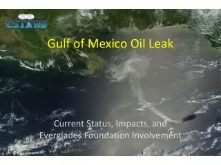
Recent Developments • Dramatic increases in nutrient loads -eutrophication -decreases in primary productivity -Wetland habitat in rapid decline -decrease in water quality -losses to commercial fishing
Governmental Response • Total Maximum Daily Load (TMDL) -assessment of pollutants in major rivers -management plan to improve water quality Estuarine Reserve Program -modeling of individual systems -protection from development
http://marine.usgs.gov http://mfengine.nos.noaa.gov http://eol.jsc.nasa.gov/sseop/clickmap.html http://infoplease.lycos.com http://www.epa.gov/owow/ estuaries http://www.epa.gov/owow/tmdl/ states http://www.rodnreel.com/tides Maps-US Atlantic and Gulf Coast (NOAA) Publications- EPA, The Ecological Condition of Estuaries in the Gulf of Mexico References