CLOUD
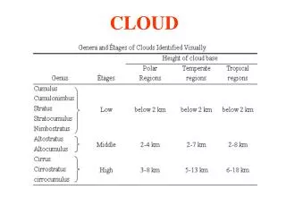
CLOUD. Cumulus(Cu). Cumulonimbus(Cb). Stratus(St). Stratocumulus(Sc). Nimbostratus(Ns). Altostratus(As). Altocumulus(Ac). Cirrus(Ci). Cirrostratus(Cs). Cirrocumulus(Cc). Cumulus Cloud (Cu).

CLOUD
E N D
Presentation Transcript
Cumulus(Cu) Cumulonimbus(Cb) Stratus(St) Stratocumulus(Sc) Nimbostratus(Ns) Altostratus(As) Altocumulus(Ac) Cirrus(Ci) Cirrostratus(Cs) Cirrocumulus(Cc)
Cumulus Cloud (Cu) Cumulus cloud takes on a variety of shapes, but most often it looks like a piece of floating cotton with sharp outlines and a flat base. The base appears white to light gray, and on a humid day, may be only 1000m (3300ft) above the ground and a kilometer or so wide. The top of the cloud-often in the form of rounded tower-denotes the limit of rising air and is usually not very high. These clouds can be distinguished from stratocumulus usually occur in groups or patches. Also, the cumulus has a done or tower-shaped top as opposed to the generally flat tops of the stratocumulus. Cumulus cloud that show only slight vertical growth are called cumulus humilis and are associated with fair-weather; therefore, we call these clouds “fair-weather cumulus”. Ragged-edge cumulus clouds that are smaller than cumulus humilis and scattered across the sky are called cumulus fractus. back
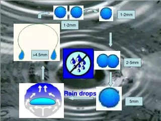
Cumulonimbus Cloud (Cb) Cumulonimbus is one kind of cloud with vertical development. It develops from cumulus and its base is around 600 meters above the land surface and is dark. Its top may extend up to tropopause, over 12,000 meters. Matter constitutes the cumulonimbus at the lower(warmer) part are large droplets, ice crystals at the top and droplets、ice crystals both at the middle. The surface of cumulonimbus is both flat at the top and bottom and is fibrous at the top edges. Phenomena come with strong cumulonimbus are lighting、 thunder、shower、violent tornadoes. back
Stratus Cloud (St) Stratus is a uniform grayish cloud that often covers the entire sky. It resembles a fog that does not reach the ground. Actually, when a thick fog “lifts,” the resulting cloud is a deck of low stratus. Normally, no precipitation falls from the stratus, but sometimes it is accompanied by a light mist or drizzle. This cloud commonly occurs over Pacific and Atlantic coastal waters in summer. A thick layer of stratus might be confused with nimbostratus, but observing the low base of stratus cloud and remembering that light-to-moderate precipitation occurs with nimbostratus can make the distinction between them. Moreover, stratus often has a more uniform base than does nimbostratus. Also, a deck of stratus may be confused with a layer of altostratus. However, if you remember that stratus are lower and darker gray and that the sum normally appears “watery” through altostratus, the distinction can be made. back
Stratocumulus Cloud (Sc) Stratocumulus clouds generally appear as a low, lumpy layer of clouds, the spreading remains of much larger cumulonimbus clouds. They range in color from dark gray to light gray and can appear in rows, patches, or as rounded masses with breaks of clear sky in between rain or snow rarely fall from these clouds and they are larger than altocumulus in appearance (about the size of a clenched fist at arms length - altocumulus are about the size of a thumbnail). back
Nimbostratus Cloud (Ns) The nimbostratus is a dark gray wet-looking cloudy layer associated with more or less continuously of this precipitation is usually light or moderate. It is never of the heavy showery variety. The base of the nimbostratus cloud is normally impossible to identify clearly and its top may be over 3000m higher. Nimbostratus is easily confused with the altostratus. Thin nimbostratus is usually darker gray than thick altostratus and you normally cannot see the sun or moon through a layer of nimbostratus. Visibility below a nimbostratus cloud deck is usually quite poor because the rain will evaporate and mix with the air in the region. back
Altostratus Cloud (As) The altostratus is a gray or blue-gray cloud composed of ice crystals and water droplets. Altostratus clouds often cover the entire sky across an area that extends over many hundreds of square kilometers. In the thinner section of the cloud, the sun(or moon)may be dimly visible as a round disk, as if the sun were shining through ground glass. Thick cirrostratus clouds are occasionally confused with thin altostratus clouds. The face that halos only occur with cirri- form clouds also helps one distinguish them. Another way to separate the two is to look at the ground for shadows. Altostratus clouds often form ahead of storms having widespread and relatively continuous precipitation. If precipitation falls from an altostratus, its base usually lowers. If the precipitation reaches the ground, the cloud is then classified as nimbostratus. back
Altocumulus Cloud (Ac) Altocumulus clouds are middle clouds that are composed mostly of water droplets and are rarely more than 1 km thick. They appear as gray, puffy masses, sometimes rolled out in parallel waves or bands. Usually, one part of the cloud is darker than another, which helps to separate it from the higher cirrocumulus. Also, the individual puffs of the altocumulus appear larger than those of the cirrocumulus. back
Cirrus Cloud (Ci) The appearances of the cirrus are very special. They look like a feathery patch with a faint wisp of a tail at one end. Cirrus clouds usually move across the sky from west to east, indicating the prevailing winds at their elevation, and they generally point to fair, pleasant weather. back
Cirrostratus Cloud(Cs) The thin, sheet-like, high-level clouds that often cover the entire sky are cirrostratus, which are so thin that the sun and moon can be clearly seen through them. The ice crystals in these clouds refract the light passing through them and will often produce a halo. In fact, the veil of cirrostratus may be so thin that a halo is the only clue to its presence. Thick cirrostratus clouds give the sky a glary white appearance and frequently form ahead of an advancing storm hence, they can be used to predict rain or snow within 12 to 24 hours, especially if they are followed by middle-type clouds. back
Cirrocumulus Cloud(Cc) Cirrocumulus consists of pure-ice sometimes with strongly frozen liquid water. It collects of the small water drops in thin cloud mass, appearance dapples or ripples, white and no shadow, cloud sheet mix or isolate at all. Whole of them fall straight, regulation into rank. Often they change from cirrus and cirrostratus also disperses from altostratus. back