Download

1 / 59
600 likes | 1.49k Views
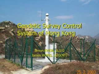
Geodetic Survey Control System of Hong Kong. Simon KWOK, SLS/G James WONG, LS/G(NT). Contents. Introduction History of development Types of Geodetic Survey Control Station Accuracy Standards Calibration baselines and network

E N D
Geodetic Survey Control System of Hong Kong Simon KWOK, SLS/G James WONG, LS/G(NT)
Contents • Introduction • History of development • Types of Geodetic Survey Control Station • Accuracy Standards • Calibration baselines and network • Specification and Practice Guide for establishing GPS control stations • Q and A
Development History • Horizontal Control Network • Vertical Control Network • GPS Control Network
Horizontal Control Network 1845 • Triangulation stations first appeared on the map of Hong Kong produced by Lt. Collinson R.E. 1899/1900 • Appeared on a map produced by Mr. Tate 1903/1904 • Appeared on another map compiled by Mr. W.J. Newland
1845, 1899/1900, 1903/1904 Although triangulation stations are shown on these maps, there is no survey record found for the triangulation.
Horizontal Control Network 1928/29 • A military map of scale 1/20,000 was produced from air photographs taken in 1924/25 by the R.A.F. with ground controls provided by the 2nd Colonial Survey Section R.E. • These ground controls were adjusted by the Geographical Section in 1928-30 1946 • The above-mentioned ground control were re-adjusted by the Crown Lands and Survey Office in 1946. • It was adopted as the Main Triangulation of Hong Kong on which all surveys were based up to 1963.
Horizontal Control Network 1963 • A re-triangulation was carried out because the network of that time could not meet the requirements of large scale mapping and cadastral surveys. • Hong Kong (1963) Geodetic Datum • Reference Ellipsoid : Clarke 1858 • Datum Origin :Old Trig. “Zero” • Hong Kong (1963) Grid System • Map Projection : Cassini Projection • Projection Origin : Old Trig. No.2
Horizontal Control Network 1975-77 • Metrication policy in the 1970s • Imperial grid was converted to metric unit of measure • Grid origin was further shifted 3550 m to the west
Horizontal Control Network 1978-1979 • Introduction of EDM • Re-survey the distances between hilltop stations for improving the consistence and accuracy of the control network • HK 1980 Geodetic Datum • Reference Ellipsoid : International Hayford (1910) • Hong Kong 1980 Grid System • Map projection : Transverse Mercator Projection
Hong Kong 1980 Geodetic Datum • Reference Ellipsoid : International Hayford (1910) • Semi-major axis (a) = 6378388 m • Flattening (f) = 1 / 297 • Origin : Old Trig. “Zero” at the Observatory • Latitude : 22° 18’ 12.82” N • Longitude : 114° 10’ 18.75” E • Azimuth • Trig. 67.2 to Trig. 94 : 292° 59’ 46.5” • Determined by astronomical Observations in 1960 by a team of visiting Geodesists who assessed the accuracy to be ±0.2”
Hong Kong 1980 Grid System • Reference Ellipsoid : International Hayford (1910) • Map Projection : Transverse Mercator • Projection Origin : Old Trig. 2 • Latitude : 22° 18’ 43.68” N • Longitude : 114° 10’ 42.80” E • Northing : 819069.80 m • Easting : 836694.05 m • Scale Factor • Unity along central meridian at old Trig. 2
Vertical Control Network 1866 • The surveyors of the surveying vessel “Rifleman” fixed a bench mark (Rifleman’s Bolt) for surveying the foreshore of Victoria Harbour. • The highest point of the Bolt was taken as 17 feet 10 inches above the zero level which is now known as the Hong Kong Principal datum (HKPD). • All heights and levels on land refer to this datum.
Vertical Control Network Rifleman’s Bolt • Originally fixed on the wall of No.12 storehouse of Naval Dockyard in Admiralty • Upon demolition of the Dockyard, the Bolt was relocated and refixed on the wall of Blake Block in H.M.S. Tamar Naval Base in Central • Preserved for its historical value and not to be used as a bench mark • In 1997, the British Forces donated the Rifleman’s Bolt to SMO
GPS Control Network • 1991 GPS Network • 2000 GPS Network • Satellite Positioning Reference Station Network
1991 GPS Network • First Hong Kong GPS Network • Joint Survey : Hong Kong, Macau and British Forces (512 Specialist Team Royal Engineers (STRE)) • Hong Kong Network : 15 Stations • 13 existing triangulation stations • 4 satellite Doppler stations • Absolute position of Doppler stations as origin • Reference frame : WGS84 (STRE 91)
1991 GPS Network Purpose • Link the local datum HK80 to WGS84 (STRE91) • Enable GPS equipment to be used for surveying Problem of the 1991 GPS Network • On the top of mountains • Difficult to access
2000 GPS Network Densification of 1991 GPS Network • on low ground • near vehicular access • reduce logistic cost
2000 GPS Network • 46 stations • Average distance between stations : 10km • Average Observation Time of each GPS baseline : 3 hours • No. of repeated baselines ≥ 3 • Relative accuracy : ± 3mm ± 1 ppm
Comparison of Internal Accuracy (1991 vs 2000) • 1 ppm scale error in the 1991 GPS Network Reasons: • Full constellation of NAVSTAR satellite was not available before 1994 • GPS hardware and software are improving during this decade • 2000 GPS Network is more accurate.
Reference Frame • WGS 84 (STRE 91) • Origin at the centre of Earth • Doppler positioning measurement technique • 1 to 2 meter absolute accuracy • ITRF • More accurate realization of the reference frame • Use combination of space techniques • GPS, VLBI, SLR, DORIS • cm level absolute accuracy • Nowadays : Broadcast and precise ephemeris are based on ITRF system.
Connection of 2000 GPS Network to ITRF96 • 2 Hong Kong Permanent GPS Reference Stations • Fanling • Kau Yi Chau • 6 Global Stations of International GPS Services for Geodynamics (IGS) • Cocos Islands (Indian Ocean) • Guam (Pacific Ocean) • Lhasa (Western China) • Shanghai (Eastern China) • Tsukuba (Japan) • Yarragadee (Australia)
Connection of 2000 GPS Network to ITRF96 • 2 months continuous GPS observation data • Baseline length : 1200 km to 5000 km • Accuracy of the ITRF96 coordinates determined in this survey is better than 2 cm • Hong Kong 2000 GPS Network shall be the GPS reference datum for all GPS surveys in Hong Kong
Satellite Positioning Reference Station Network 2001 – Phase I • 6 stations were constructed and operating. 2004 – Phase II • Other 6 stations shall be established.
Satellite Positioning Reference Station Network • Territory-wide array of permanent GPS reference stations • Total 12 stations • Station Separation : 10 to 15 km • In most of the Hong Kong area, users can measure baselines from at least 2 permanent stations which are within a distance of 10 km. • Relative Accuracy : ± 3 mm ± 0.2 ppm
Types of Geodetic Survey Control Stations • Horizontal Control Stations • Vertical Control Stations • Satellite Positioning Reference Stations
Horizontal Control Stations Number of Stations in Hong kong • Main / Minor Triangulation Station : 230 (Approx.) • Main / Minor Control Traverse Station : 3500 (Approx.)
Horizontal Control Stations • Type A Triangulation Monument • Type B Triangulation Monument • Picket Box (fixed in open ground) • Picket Box with concrete platform • Picket Box (fixed on rock surface) • Urban Survey Mark
Vertical Control Stations Number of Bench Marks in Hong kong : 1500 (Approx.)
Vertical Control Stations • Stainless Steel Rod Bench Mark • Stainless Steel Staple • Bedrock Bench Mark
Satellite Positioning Reference Stations Existing 6 Stations • Siu Lang Shui (HKSL) • Lam Tei (HKLT) • Kam Tin (HKKT) • Fanling (HKFN) • Shatin (HKST) • Stonecutters Island (HKSC)