Download
1 / 26
260 likes | 467 Views
Zoltan Toth Global Systems Division NOAA/OAR/ESRL Acknowledgements: Forecast Applications Branch. NUMERICAL WEATHER PREDICTION IN VERY SHORT TERM WIND FORECASTING. HISTORICAL OVERVIEW & STATUS. T-LAPS – Terminal Local Analysis & Prediction System

E N D
Zoltan Toth Global Systems Division NOAA/OAR/ESRL Acknowledgements: Forecast Applications Branch NUMERICAL WEATHER PREDICTION IN VERY SHORT TERM WIND FORECASTING
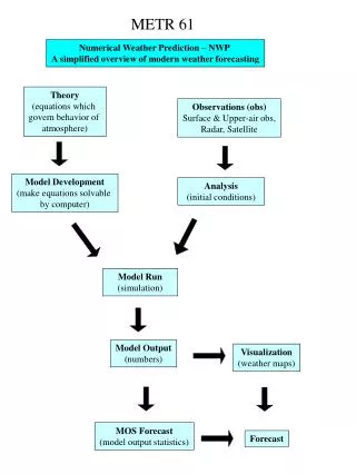
HISTORICAL OVERVIEW & STATUS • T-LAPS – Terminal Local Analysis & Prediction System • Fine scale (5 km?) analysis of 3D winds around 40 terminals since early 1990s - ITWS • Revolutionary solution at the time • Still used in operations today (20-year old system) • Statistical nowcasting tools have limitations • NWS operational systems today (NAM, RAP) • ~ 12 km resolution • Analysis has insufficient detail • Forecast does not resolve features of interest
WHAT HAS CHANGED • User needs - Demand for analyses and forecasts that are • More accurate • More detailed • 3D gridded • Supporting specific decision tool • Scientific readiness – Advances in • Data assimilation - 4DVAR, hybrid, multiscale methods • Numerical modeling – Boundary layer, microphysics, etc • Ensembles to quantify uncertainty for decision making • Observing systems – New instruments / platforms • Various profilers, radiometrics • Computing • Massively parallel architectures, Graphical Processing Units, Fine Grain computing, etc
TRADITIONAL 3DVAR, LAPS,& VAR-LAPS LAPS 3DVAR with small-scale covariance TRUTH 3DVAR Medium- scale VAR-LAPS 3DVAR with large-scale covariance
NEW REVOLUTION FOR 0-3 HOUR FORECASTS? NWP-based very short term forecasting possible • Paradigm shiftsdue to major advances in 4 areas • From statistically based nowcasting tools & subjective methods to • Statistically enhanced NWP guidance • From disjoint efforts focusing on different AIVs to • Holistic approach based on gridded NWP guidance • Same core system with specific end user applications serving multiple users • Vision • 1 km resolution national NWP-based system • Analysis with 5-min update frequency • Forecast for 0-3 hours, with 15-min frequency • Statistical processor to reduce systematic errors and blend with latest obs
WARN ON FORECASTING (WOF) – ARE WE GETTING THERE? Variational LAPS • On occasion, variational LAPS superior to advection and persistence
WHAT’S NEEDED? NWP-based very short term forecasting • Observations • Use all existing observations • Asses additional needs – Observing System Simulation Experiments • Deploy systems near terminals – focus on lower atmosphere • NWP data assimilation • Focus on fine scales – multiscale methods • 4-DVAR • Dynamical & physical balances for forecast initialization • Numerical forecasting • Boundary layer & microphysics parameterizations • Variable resolution models for enhancements near terminals • Ensembles to quantify forecast uncertainty
TO MAKE & COMPLETE THE FORECAST • Computing • GPU or other fine grain solutions • Statistical postprocessing • Modify / reconfigure existing nowcasting tools to use NWP guidance • Bayesian methods to fuse predictive information from • NWP guidance • Latest observations • Conditional climatology • User applications – Aviation • Wind compression • Runway wind shifts • Visibility • Icing • Turbulence • Precipitation incl type • Lightning • Convection
Cloud / Reflectivity / Precip Type (1km analysis) - Loop Obstructions to visibility along approach paths DIA
APPLICATIONS / NEEDS - NWS • High quality digital TAF – WFOs • Wind compression / approach decisions – CWSUs • Automated frontal analysis – NCEP/HPC • Severe weather initiation – NCEP/SPC • Fire Weather – WFOs • Marine forecasting - WFOs
Variational LAPS, Mar. 23, 2011 1230Z Front analysis for the case of Divergence field
FIRE WEATHER APPLICATION Variational LAPS Incident report Downscaling Fine Scale Forecast Regional scale data Fill in details
Example of Downscaling: Four Mile Canyon Fire Surface U wind (colors) 36 33 30 27 24 21 18 15 12 9 6 3 0 -3 -6 Initial input at 8km res NORTH-SOUTH Contour lines: topography 0 100 200 EAST – WEST (km) Downscaled output at 1km resolution Finer details in wind in response to high resolution terrain 0 200 100 EAST – WEST (km)
APPLICATIONS / NEEDS – DoD & DHS • Dispersion forecasting – DHS • Precision drops – US Army • Toxic air alerts for rocket launches – USAF – RSA • Nuclear pollution tracking – USAF – AFTAC • Dispersion – toxic plume prediction – DHS – GTAS • Theater forecasts
LAPS Applications: High Resolution LAPS is used to initialize WRF model runs and other systems around the globe Personnel: Linda Wharton, IsidoraJankov, Steve Albers, Dan Birkenheuer - FAB RSA(Range Standardization And Automation System) LAPS AWIPS II PADS WRF WRF WRF WRF WRF WRF WRF WRF WRF WRF DFW SEA NYC KSC Ensemble AFTAC(Air Force Technical Applications Center)
RSA - Range Standardization and Automation Weather Support System … to support dispersion models predicting where toxic plumes from rocket launches will go. … to provide high resolution weather data to help with launch decisions. OAR/ESRL/GSD/Forecast Applications Branch
PADS - Precision Air-Drop System Geo-Targeted Alerting System Provides air dispersion and toxic plume information along with NOAA meteorological and environmental data to state and local emergency management agencies. AFTAC - Air Force Technical Applications Center Provides nuclear treaty monitoring, nuclear event detection and analyzes disturbing events for nuclear identification.
LAPS USER BASE • Private Sector • Weather Decision Tech., Hydro Meteo, • Precision Wind, Vaisala, Telvent • International agencies (10+ countries) • KMA, CMA, CWB, Finland (FMI), Italy, Spain, • BoM (Australia), Canary Islands, HKO, • Greece, Serbia, Nanjing Inst. of Met. • NOAA • ~120 WFOs (via AWIPS), ARL, NESDIS • Other US Agencies • DHS, DoD, FAA, CA DWR, GA Air Qual. • Academia • Univ of HI, Athens, Arizona, CIRA, UND, McGill
LAPS SCIENTIFIC IMPACT – REFEREED PAPERS • 30 refereed publications by GSD/NOAA • 1-2 refereed papers per year • 391 citations in refereed papers • ~ 40 / year recently
LAPS SCIENTIFIC IMPACT – ALL PUBLICATIONS LAPS NOAA, local analysis and prediction system • Queryperiod: 1989 - 2012-10-11 • 432 Papers • 4163 Citations • Cites/year: 181.00 • Cites/paper: 9.64/0.0/0 (mean/median/mode) • Cites/author: 1975.61 • Papers/author: 221.50