Download
1 / 47
480 likes | 890 Views
Chapter 6: General Circulation. This chapter discusses: Mean Sea Level Pressure and Winds Zonal winds Meridional Transport of Momentum, Heat and Moisture. Thermal Circulations.

E N D
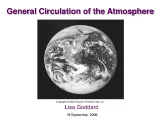
Chapter 6: General Circulation • This chapter discusses: • Mean Sea Level Pressure and Winds • Zonal winds • Meridional Transport of Momentum, Heat and Moisture
Thermal Circulations Solar heating and radiational cooling of earth's surface generates cold-core thermal highs and warm-core thermal lows. Winds can circulate between these two systems.
Wind Profiles Changes in air temperature causing warm air to rise and cool air to sink can also generate horizontal winds. Rising warm air creates a surface low and upper level high. Sinking cool air creates a surface high and upper level low.
Forces & Motion Pressure forces are only one influence on the movement of atmospheric air. Air responds similarly as water to this force, moving from higher pressure to lower pressure. Centripetal, friction, and apparent Coriolis are other forces, however, determining winds.
Sea and Land Breezes Land heats more quickly than water, creating land-water temperature differences along a coastline. During the day the land's warm-core thermal low draws a sea breeze, while at night, the warmer sea draws a land breeze.
Variation in Height Isobaric (constant pressure) surfaces rise and fall in elevation with changes in air temperature and density. A low 500 mb height indicates denser air below, and less atmosphere and lower pressure above. Contour lines indicate rates of pressure change.
Ridges & Troughs Upper level areas with high pressure are named ridges, and areas with low pressure are named troughs. These elongated changes in the pressure map appear as undulating waves.
Surface & 500 mb Maps Surface maps chart pressure contours, highs and lows, and wind direction. Winds blow clockwise around highs, called anticyclones. 500 mb maps reveal patterns that on average are 5600 m above the surface, where westerly winds rise and fall across ridges and troughs.
Pressure Gradient Force Change in pressure per change in distance determines the magnitude of the pressure gradient force (PGF). Greater pressure changes across shorter distances creates a larger PGF to initiate movement of winds.
PGF vs. Cyclonic Winds Pressure gradient force (PGF) winds acting alone would head directly into low pressure. Surface observations of winds, such as the cyclonic flow around this low, reveal that PGF winds are deflected by other forces.
Apparent Coriolis Force Earth's rotation transforms straight line motion into curved motion for an outside viewer. The Coriolis force explains this apparent curvature of winds to the right due to rotation. Its magnitude increases with wind velocity and earth's latitude.
Actual & Observed Paths Airplane travel paths have an apparent curvature, just as Coriolis forces affect winds. Again, the deflection between actual and observed paths is greater near the poles.
Geostrophic Wind Winds have direction and magnitude, and can be depicted by vectors. Observed wind vectors are explained by balancing the pressure gradient force and apparent Coriolis force. These upper level geostrophic winds are parallel to pressure contours.
Wind Speed & Pressure Contours Just as a river speeds and slows when its banks narrow and expand, geostrophic winds blowing within pressure contours speed as contour intervals narrow, and slow as contour intervals widen.
Isobars & Wind Prediction Upper level pressure maps, or isobars, enable prediction of upper level wind direction and speed.
Northern & Southern Hemisphere Flow Winds blow counterclockwise around low pressure systems in the Northern Hemisphere, but clockwise around lows in the Southern Hemisphere.
Friction & Surface Winds Surface objects create frictional resistance to wind flow and slows the wind, diminishing the Coriolis force and enhancing the effect of pressure gradient forces. The result is surface winds that cross isobars, blowing out from highs, and in toward lows. Figure 9.29A
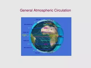
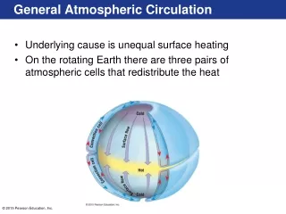
Single-Cell Circulation Model The basis for average air flow around the earth can be examined using a non-rotating, non-tilted, ocean covered earth. Heating is more intense at the equator, which triggers Hadley cells to redistribute rising heat from the tropical low to the polar highs.
Three Cell Circulation Model A rotating earth breaks the single cell into three cells. The Hadley cell extends to the subtropics, the reverse flow Ferrel cell extends over the mid latitudes, and the Polar cell extends over the poles. The Coriolis force generates westerlies and NE trade winds, and the polar front redistributes cold air.
Observed Winds in January Observed average global pressure and winds have increased complexity due to continents and the tilted earth. Differential ocean-land heating creates areas of semi-permanent high and low pressure that guide winds and redistribute heat.
Observed Winds in June Global pressure and wind dynamics shift as the Northern Hemisphere tilts toward the sun, bringing the inter-tropical convergence zone, the Pacific high, and blocking highs in the southern oceans northward.
North American Winter Weather Semi-permanent highs redirect North American winds, such as cold interior northerly flow from the Canadian high. The Polar front develops a wave like pattern as air flows around lows.
Global Precipitation Patterns Global low pressure zones around the equator and 60° latitude generate convergence at the surface, rising air and cloud formation. Zones of high pressure at 30° and the Poles experience convergence aloft with sinking, drying air.
Coastal Summer Weather The semi-permanent Pacific high blocks moist maritime winds and rain from the California coast, while the Bermuda high pushes moist tropical air and humidity over the eastern states.
Coastal Winter Weather During winter months, the Pacific high migrates southward and allows for maritime winds with moisture and rains to reach California. On the east coast, precipitation is rather even throughout the year.
Mean Sea Level Pressure (January) http://www.atmo.arizona.edu/students/courselinks/spring03/atmo421/sealevelpressure.html
Excerpt: RIME OF THE ANCIENT MARINER Samuel Taylor Coleridge The fair breeze blew, the white foam flew, The furrow followed free: We were the first that ever burst Into that silent sea Down dropt the breeze, the sails dropped down, Twas sad as sad could be; And we did speak only to break The silence of the sea! All in a hot and copper sky The bloody Sun, at noon, Right up above the mast did stand, No bigger than the moon. Day after day, day after day, We stuck, nor breath nor motion: As idle as a painted ship Upon a painted ocean.
Excerpt: RIME OF THE ANCIENT MARINER Samuel Taylor Coleridge The fair breeze blew, the white foam flew, The furrow followed free: (The trades) We were the first that ever burst Into that silent sea Down dropt the breeze, the sails dropped down, Twas sad as sad could be; And we did speak only to break (The doldrums) The silence of the sea! All in a hot and copper sky The bloody Sun, at noon, (Vicinity of the ITCZ) Right up above the mast did stand, No bigger than the moon. Day after day, day after day, We stuck, nor breath nor motion: As idle as a painted ship Upon a painted ocean.
Meridional & Zonal Flow Wind direction and speed are indicated by lines, barbs, and flags, and appear as an archer's arrow. Upper level winds that travel a north-south path are meridional, and those traveling a west-east path are zonal.
Jet Stream High velocity Polar and subtropical jet stream winds are located to “break” the tropopause, and they oscillate along planetary ridges and troughs.
Polar Jet Formation Steep gradients of temperature change at the Polar front trigger steep pressure gradients, which then forces higher velocity geostrophic winds. This is the trigger for jet stream flow.
Winds & Angular Momentum Angular momentum is the product of mass, velocity, and the radius of curvature and it must be conserved. As northward-flowing air experiences a smaller radius, it increases in velocity and augments the jet stream flow.
Convergence & Divergence Deepening of cyclones into explosive cyclogenesis is prohibited when low pressure aloft is directly above the surface low. In this scenario, the convergence at the surface low builds up air pressure and fills in the low. The same stacking of high pressure, with divergence at the surface, will weaken the anticyclone.
Storm Vertical Structure Divergence of air aloft occurs as isobars intervals widen. Low pressure systems deepen and intensify (e.g. cyclogenesis) when upper-level divergence is stronger than the surface convergence, which requires a vertical staggering of surface and upper lows.
Summary of Cyclone Weather Upper and surface maps illustrate the role of convergence and divergence aloft, and the pattern of clouds, precipitation, and temperatures on the ground.