Download
1 / 31
330 likes | 409 Views
Learn about the underlying causes and idealized patterns of the Earth's atmospheric circulation, including the influence of continents, local winds, El Niño, La Niña, and the climatic impacts of these phenomena on precipitation distribution.

E N D
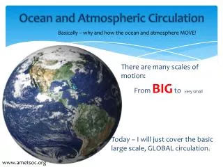
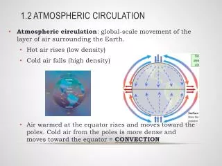
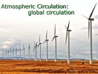
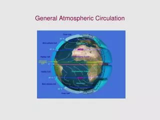
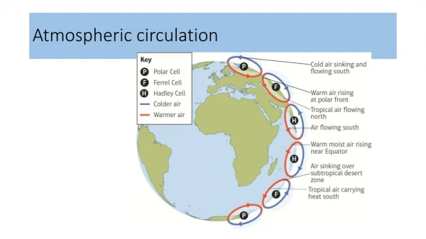
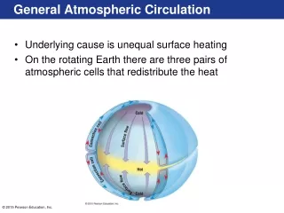
General Atmospheric Circulation • Underlying cause is unequal surface heating • On the rotating Earth there are three pairs of atmospheric cells that redistribute the heat
Idealized Global Circulation • Equatorial low pressure zone • Rising air • Abundant precipitation
Idealized Global Circulation • Subtropical high pressure zone • Subsiding, stable, dry air • Near 30 degrees latitude • Location of great deserts • Trade winds • Westerly winds
Idealized Global Circulation • Subpolar low pressure zone • Warm and cool winds interact • Polar front – an area of storms • Polar high pressure zone • Cold, subsiding air • Polar easterly winds • Polar front
General Atmospheric Circulation • Influence of continents • Seasonal temperature differences disrupt the • Global pressure patterns • Global wind patterns • Influence is most obvious in the Northern Hemisphere
General Atmospheric Circulation • Influence of continents • Monsoon • Occur over continents • During warm months • Air flows onto land • Warm, moist air from the ocean • Winter months • Air flows off the land • Dry, continental air
Westerlies • Mid latitudes • Air flow is interrupted by cyclones • Cells move west to east in the Northern Hemisphere • Create anticyclonic and cyclonic flow • Paths of the cyclones and anticyclones are associated with the upper-level airflow
Local Winds • Produced from temperature differences • Small scale winds • Types • Land and sea breezes • Mountain and valley breezes • Chinook and Santa Ana winds
Measuring Wind • Two basic measurements • Direction • Speed
Measuring Wind • Direction • Winds are labeled from where they originate (e.g., north wind – blows from the north toward the south) • Instrument for measuring wind direction is the wind vane
Measuring Wind • Direction • Direction indicated by either • Compass points (N, NE, etc.) • Scale of 0° to 360° • Prevailing wind comes more often from one direction
Measuring Wind • Speed – often measured with a cup anemometer
Measuring Wind • Changes in wind direction • Associated with locations of • Cyclones • Anticyclones • Often bring changes in • Temperature • Moisture conditions
El Niño and La Niña • El Niño • A countercurrent that flows southward along the coasts of Ecuador and Peru • Warm • Usually appears during the Christmas season • Blocks upwelling of colder, nutrient-filled water, and anchovies starve from lack of food • Strongest El Niño events on record occurred between 1982–83 and 1997–98
El Niño and La Niña • El Niño • 1997–98 event caused • Heavy rains in Ecuador and Peru • Ferocious storms in California
El Niño and La Niña • El Niño • Related to large-scale atmospheric circulation • Southern Oscillation -- Pressure changed between the eastern and western Pacific • Changes in trade winds creates a major change in the equatorial current system, with warm water flowing eastward
El Niño and La Niña • El Niño • Effects are highly variable depending in part on the temperatures and size of the warm water pools
El Niño and La Niña • La Niña • Opposite of El Niño • Triggered by colder than average surface temperatures in the eastern Pacific • Typical La Niña winter • Blows colder than normal air over the Pacific Northwest and northern Great Plains while warming much of the rest of the United States • Greater precipitation is expected in the Northwest
El Niño and La Niña • Events associated with El Niño and La Niña are now understood to have a significant influence on the state of weather and climate almost everywhere
Global Distribution of Precipitation • Relatively complex pattern • Related to global wind and pressure patterns • High pressure regions • Subsiding air • Divergent winds • Dry conditions • e.g., Sahara and Kalahari deserts
Global Distribution of Precipitation • Related to global wind and pressure patterns • Low pressure regions • Ascending air • Converging winds • Ample precipitation • e.g., Amazon and Congo basins
Global Distribution of Precipitation • Related to distribution of land and water • Large landmasses in the middle latitudes often have less precipitation toward their centers • Mountain barriers also alter precipitation patterns • Windward slopes receive abundant rainfall from orographic lifting • Leeward slopes are usually deficient in moisture