Download
1 / 10
100 likes | 209 Views
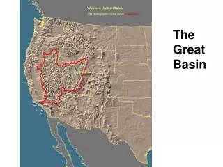
The USGS and the Development of the Nevada Great Basin Community Velocity Model. Objectives. Help Coordinate efforts between UNLV, UNR, USGS, others, to develop a Community Velocity Model (CVM) patterned after Wasatch CVM effort Make CVM available to public when completed

E N D
The USGS and the Development of theNevada Great Basin Community Velocity Model
Objectives • Help Coordinate efforts between UNLV, UNR, USGS, others, to develop a Community Velocity Model (CVM) patterned after Wasatch CVM effort • Make CVM available to public when completed • Develop Urban Seismic Hazard Maps for Reno and Las Vegas Metropolitan Areas
Seattle 3D Vs Velocity Model used in Seattle Urban Seismic Hazard Maps Vs (m/s) N USGS Open-File Report 2007-1175 http://pubs.usgs.gov/of/2007/1175
Urban Seismic Hazard Map New map w/ ground motion simulation results (basin effects, rupture directivity, and nonlinear soil response at soft-soil sites) 2002 National Seismic Hazard Map w/ NEHRP Amplification factors based on Vs30 1 Hz S.A. (%g) with 2% Prob. Of Exceedance in 50 Years
Information Important in Developing Community Velocity Models(not inclusive and area dependent) • Regional Geology (including basin Quaternary units and all active faults) • Realistic Basin Geometry (from gravity, seismic tomography, boreholes, etc.) • Geotechnical Data (borehole) • Geophysical Data (Vs, Vp, density, attenuation, etc.)
Possible Steps for Research Community to Reach Objectives • Coordinate the compilation of all existing relevant data (how much data is there?) • Develop model with existing data (using searchable code (e.g. Wasatch CVM) , ModelAssembler, 3rd party 3D software) • Model validation (determine what additional data is needed, where is it most needed) • Acquire new data/incorporate into Model
Funding (???) • Dependent on Funding levels from Congress • Historically, ~$120k has been available for these type of efforts every year in National/Intermountain West panels • Translates into ~1-2 proposals funded annually • USGS has historically collaborated on data acquisition with internal funding and anticipates doing so, if needed
Wasatch Front Stacked Migrated Seismic Depth Section W E Processing Datum = 1450 m elevation 200 400 Depth (m) 600 800 1000 1200 Vertical exag. 2:1