Download
1 / 22
230 likes | 420 Views
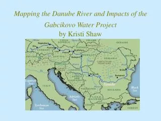
Mapping the Danube River and Impacts of the Gabcikovo Water Project by Kristi Shaw. Data Sources. Digital Chart of the World University of New Hampshire/GRDC Global Composite Runoff Data Set (v 1.0) Basin Data Potential Simulated Topological Networks (STN-30P)

E N D
Mapping the Danube River and Impacts of the Gabcikovo Water Projectby Kristi Shaw
Data Sources • Digital Chart of the World • University of New Hampshire/GRDC Global Composite Runoff Data Set (v 1.0) • Basin Data • Potential Simulated Topological Networks (STN-30P) • Global River Discharge Database (RivDis 1.1) • USGS EROS Data Center Hydro1K Elevation Derivative Database • Europe Atlas CD (2000)
Digital Elevation Model(taken from USGS Hydro1-Europe Dataset)
Mapping the Danube River using Arc View 3.2 • Selected countries in Digital Chart of the World • Ponet (polygon), Dnnet (arc), Dnpoint converted to shapefiles • Category: Projections of the World • Type: Geographic • Map Units: Decimal Degrees
Comparison of DCW Basin with UNH/GRDC STN-30p Basin • UNH/GRDC Potential Simulated Topological Networks (30 minute spatial grid system) and UNH/GRDC Composite Runoff Fields • Danube river and tributaries shapefiles provided by Europe Atlas CD (special thanks to Mustafa Akcay)
Selecting for the Danube River Network • Tributaries: Inn, Morava, Mura, Drava, Sava, Tisza, Mures, Olt, Siret, Prut • Removed all unrelated rivers using start editing tool and • Using Geoprocessing extension to merge river themes from each country into one theme
Network Connectivity using Arc Info 8.0 • Created new personal geodatabase and then followed with new feature dataset (selecting Geographic Coordinates in GCS_WGS_1984 projections) • Coverage to geodatabase from Merge1.shp (danube1) adding two sinks in ArcMap • Geometric Network Wizard (danube1, outlet (sink)) • Danubegeo_junctions created
Geographic Projection of Danube River and River Stations • Projection Utility Wizard (Geographic Projection with GCS North American 1927 Datum) • Selected Danube Stations (points) from UNH RivDis 1.1 • did not coincide with river (line)
Danube River Stations with December 1984 Flow Rates (m3/sec)
Danube River Stations (Min Flow Rate, Station Name, Max Flow Rate)
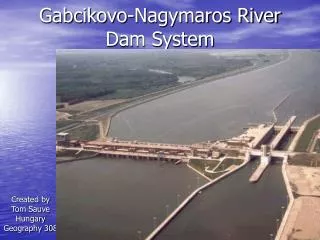
Gabcikovo Water Project Approximately 100 miles
Danube River (with Gabcikovo Water Project) Original Danube River
Hungary Gabcikovo would adversely affect water quality increasing deposits of polluted clay in reduced flow regions Lowering of water table Danube villages flooded Ceased involvement 1989 Change international boundary (trading tariffs(?)) Slovakia Guarantee 95% minimum flow rate along original Danube Hydroelectric-power station provided nearly 2 billion KWH electrical energy during first year Replenish flow in river reaches near reservoir Significant financial investment Opposing Views
Alternative C (I) • After discussion and deliberation, Alternative C began construction in July 1991
Alternative C (II) • Reservoir • Connection Dike (Dam) • Headrace Canal • Gabcikovo River Step (hydroelectric power station and two navigation locks
Gabcikovo Water Project • Reduced to approximately 30 miles
Limiting Factors • Flow Data unavailable for post-1992 (to compare effects of the Gabcikovo project) • Lack of scientific evidence available regarding effects of the Gabcikovo • Language barrier • Data available often did not include reference datum and/or projection