Download
1 / 6
60 likes | 360 Views
State the main aim of a fieldwork investigation that you have undertaken. State a hypothesis or research question that you set up and explain how this helped you to achieve your aim. (3).

E N D
State the main aim of a fieldwork investigation that you have undertaken. State a hypothesis or research question that you set up and explain how this helped you to achieve your aim. (3) The aim of our fieldwork was to see how various river characteristics change as we move downstream from the source. One such characteristic is discharge. Our hypothesis relating to this is as distance downstream from source increases discharge will increase. By investigating this hypothesis, we are investigating one of the river characteristics that the theory says will change as you go downstream. It will also tell us about related properties such as cross sectional area and velocity. Explain the geographical concept, process or theory that underpinned your fieldwork enquiry. (4) The geographical theory that underpins our fieldwork is that river discharge increases as we move downstream from source to mouth. Discharge is cross sectional area times velocity. So discharge will increase if velocity and cross sectional area increase. Cross sectional area increases down stream because more tributaries enter the river adding more water which means the river is deeper and wider (cross sectional area is equal to width times average depth). This is due to the fact that downstream the river has drained more of the drainage basin. Velocity should increase because as the river gets wider and deeper and the sediment size gets smaller there is proportionally less friction through turbulence. The result is that water flows more efficiently and so faster. It should be fastest coming out of the upper course.
State one hypothesis or research question or issue for evaluation that you have investigated. Describe one method of primary data collection used in this investigation (5) Our hypothesis was that as distance downstream from source increases velocity will increase. Using maps we identified suitable locations using systematic line point sampling (because we expected to see a pattern emerge with increased distance downstream) At each location we measured a ten metre stretch of river, using a tape measure. We held and then released an orange in the centre of the river channel and timed how long it took to travel ten metres. We repeated this process, 3 times to get an average score in an effort to be more accurate. We did this at every sample point. The velocity is calculated by dividing the distance (10m) by the time taken. This value is then multiplied by a correction factor of 0.85, to get the average velocity at that location. Discuss the limitations of your chosen method in 2aii (above question) (6) The first limitation of our chosen method related to the sampling points. In particular, we did not stick rigidly to the method of systematic line point sampling. Instead we sampled at places where we could gain access to the river (i.e. places with car parks, bridges and footpaths). When we got to the sample locations there was no system as to what exact location we measured at. Downstream where the river was deeper it may have meant subconsciously looking for shallow locations, which shows a degree of bias. We may also have selected locations where there was a faster flow and a ‘clear run’, when focusing on velocity, in order to get the data collected quicker. When measuring the ten metre length of river channel the tape was not straight and measuring the time less than precise. Lastly on occasion the orange got stuck behind large rocks. We were then uncertain as to whether we counted this measurement or not.
Outline and justify the use of one or more techniques used to analyse your results (5) The main technique we used to analyse the relationship between two variables was Spearman Rank (SR). We put our paired data in a table. We then ranked the data collected for each variable and calculated the difference in rank between each pair. The differences are squared (to get all positive values), totalled and then put into a formula, which gives us a coefficient (c). SR is a statistical technique which removes the need to interpret the data in a personal and subjective way. Rather, by plotting c on a significance graph, we can immediately see the nature, strength and level of significance of a relationship between two factors. The level of significance determines how confident we are in making conclusions from the results. SR can be used as a next step after a scattergraph has visually shown the relationship between the variables. Describe one technique that you used to present your data. Explain why this was an appropriate technique to use (7) We chose to represent our data using located cross sectional profiles of the river. This involved choosing appropriate scales (both horizontal and vertical) which would make the results easy to see when displayed. On squared paper we drew out the width of the river and plotted its depth at each sample point, before drawing a smooth curve which represented the river bed. Each cross section diagram was then placed on a large piece of display paper next to its location on a map of the area (centred on the display paper). This method allows visual synthesis of the information and provides an ‘at a glance’ way of spotting patterns, because it is highly visual. So it is possible to visually test theories between cross sectional area and distance downstream. Any suspected relationship could then be further investigated using a scattergraph and then Spearman Rank. It also allows other results (like sediment size) to be presented alongside the cross sectional area which might help explain related characteristics such as velocity.
Drawing upon your findings, explain how your enquiry improved your understanding of the topic (5) The Spearman rank correlation coefficients (c) for distance downstream (dd) and discharge was 0.74. For dd and cross sectional area (xsa) it was 0.79. Both results are significant at the 0.05 level. Dd and velocity produced a result of 0.46, which is not significant at any level. So overall, discharge (which is xsa x velocity) significantly increases as dd increases. This is mainly due to the strong increase in xsa downstream. This in turn takes place because of all of the tributaries entering the main channel, draining as they do additional parts of the drainage basin. This additional flow will mean the main channel becomes deeper and wider and so xsa increases. Velocity does not increase so strongly. Part of the reason may be due to the gentler slope gradient downstream. So while the channel roughness and hydraulic radius may work to increase velocity, the gentler slopes work against it. So velocity increases less well.
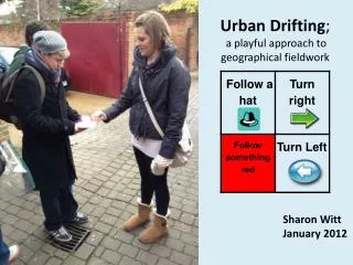
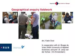
Before visiting an area for fieldwork, a risk assessment must be completed. Outline the risks associated with carrying out the fieldwork and assess the effectiveness of strategies used to minimise the risks. (5) The main risks associated with our rivers based fieldwork related to the water itself. We tried to minimise the risk of injury posed by a strong current by having our class teacher perform a ‘wobble test’ at each site. This involved him balancing on one leg in the area of strongest channel flow to ensure it was not too strong. We were forewarned about slippy, moss-covered rocks and instructed to tread slowly and carefully to the side of them where possible. We entered the river where there was a gently sloping bank, to avoid the prospect of bank collapse and resulting injury. Identifying these prime dangers meant we were confident in entering the water and successfully avoided any injury. The other main risks related to travel to each site. Seat belts reduced the risk in the mini bus and vigilance when crossing access roads meant that major injury was avoided. Describe one application of ICT skills in carrying out your fieldwork and comment on its usefulness. (5) I have used an ICT package called Memory Map during my fieldwork. This is a series of digital maps at different scales. Using the hand tool and the zoom feature it was possible to identify and understand the land uses, type of landscape as well as access points and potential hazards before arriving at the sample sites. The elevation profile and 3D fly through features were also useful in this respect. The ability to mark out a track over the river course and place equally distanced markers allowed us to sample in a way close to systematic line point sampling. This was needed because we had to regularly sample along the changing river. We could then take a large copy of the maps out into the field and in order to find our chosen sample points which made our study more precise.