Earth Sciences Sector
Earth Sciences Sector. Earth Sciences Sector. Earth Sciences Sector. Canadian Spatial Reference System. Additional slides For CGRSC Sept 18-20 , 2006. Dynamic. Fixed. 1987 WGS84 - same reference system as NAD83 (+/- 1m).

Earth Sciences Sector
E N D
Presentation Transcript
Earth Sciences Sector Earth Sciences Sector Earth Sciences Sector Canadian Spatial Reference System Additional slides For CGRSC Sept 18-20, 2006
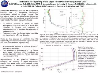
Dynamic Fixed 1987WGS84 - same reference system as NAD83 (+/- 1m) 1986NAD83 (Orig)- NAD83 reference system based on Doppler- Coordinate shifts of 1.5 m horizontally, 1 m vertically- metre-accuracy NAD83 Fixed 1988ITRF88 - geocentric ITRF89ITRF90ITRF91ITRF92ITRF93ITRF94ITRF96ITRF97ITRF2000 Dynamic 1994WGS84(G730)- aligned with ITRF91- 1.5 m different from NAD83 Small incremental changes 1997WGS84(G873)- aligned with ITRF94 2001WGS84(G1150)- aligned with ITRF2000 Reference Systems - Timeline NAD83 WGS84 ITRF 1998NAD83 (CSRS)- same NAD83 reference system- same geocentre error- same axis misalignment- cm-accuracy NAD83
NAD83(CSRS) vs NAD83(Orig.) Stations re-observed with high-order GPS Provincial Grid Shift Files
WGS84 - NAD83(CSRS) shift in 1997 Datum Transformation Parameters
Datum Shift in GPS receivers/software • Usually 3-parameter datum shift • Datum Shift Table published by NGA (National Geospatial-Intelligence Agency)formerly NIMA http://earth-info.nga.mil/GandG/publications/tr8350.2/tr8350_2.html From June 23, 2004 update • The WGS84-NAD83 datum shift values date back to 1987 when WGS84 and NAD83 were the same • If you set your receiver to • WGS84 no datum shift is applied (GPS native datum) • NAD83 a zero datum shift is applied (which is incorrect) • Either way you’re in WGS84
Datum shift in GIS software • 7-parameter datum shift values are often used (e.g. ArcPad) • Datum Shift Table published by NATO • Most GIS software • expect realtime position data (NMEA stream) to be in WGS84 • can apply a WGS4-to-Local datum shift http://earth-info.nga.mil/GandG/coordsys/datums/helmert.html • WGS84-to-NAD83 is a Zero-shift here as well
GPS fix code (1=GPS, 2=DGPS, 3=PPS, 4=RTK, 5=Float RTK) Time 15:55:32 # of Sats HDOP Latitude Longitude (in degrees and decimal minutes) H =h-N h=H +N Ellipsoidal Height originally computed by receiver = 73.7m – 34.1m =39.6 m NMEA realtime position format H N Geoid Height MSL Height No data field for Datum WGS84 Geoid height is applied