Download
1 / 37
370 likes | 388 Views
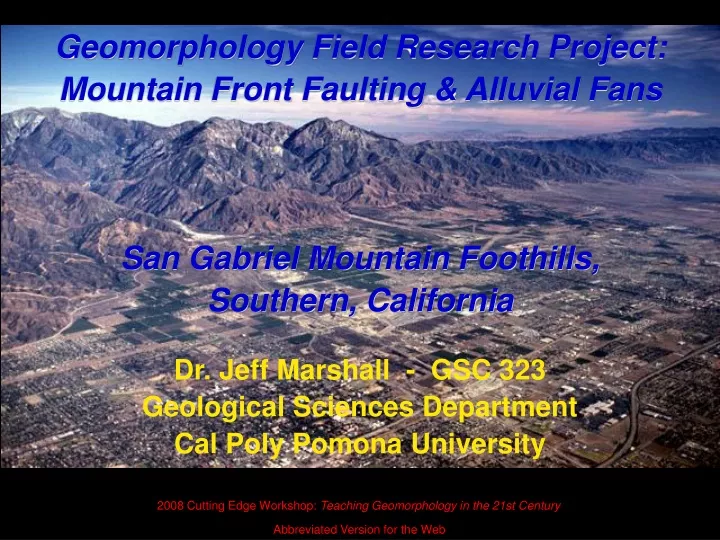
Geomorphology Field Research Project: Mountain Front Faulting & Alluvial Fans San Gabriel Mountain Foothills, Southern, California. Dr. Jeff Marshall - GSC 323 Geological Sciences Department Cal Poly Pomona University. 2008 Cutting Edge Workshop: Teaching Geomorphology in the 21st Century.

E N D
Geomorphology Field Research Project: Mountain Front Faulting & Alluvial FansSan Gabriel Mountain Foothills, Southern, California Dr. Jeff Marshall - GSC 323 Geological Sciences Department Cal Poly Pomona University 2008 Cutting Edge Workshop: Teaching Geomorphology in the 21st Century Abbreviated Version for the Web
Project Overview • Capstone project for required upper division Geomorphology course (GSC 323) • Students work in teams to investigate a local landscape system: Mountain front alluvial fans & terraces of the San Gabriel Mountains
Project Overview • Integrates learning in: • fluvial geomorphology • Quaternary stratigraphy • soils & weathering • tectonic geomorphology • climate change • landscape evolution
Project Goals The students will… • …integrate and apply their geomorphology course learning through independent research
Project Goals The students will… • …develop skills in: • teamwork • project design • literature review • fieldwork • data analysis • interpretation • report writing • oral presentation
Project Goals The students will… • …learn to think like a Geomorphologist !
Suburban sprawl along mountain front thrust faults Sierra Madre fault scarp
Mt. Baldy & San Antonio Creek Watershed An Iconic Southern California Landscape
Red Hill Rancho Cucamonga Classic field site for Alluvial Fan & Fault Studies
Eckis, R., 1928 Alluvial fans of the Cucamonga district, southern California: Journal of Geology, v. 36, p. 224-247
Eckis, R., 1928 Alluvial fans of the Cucamonga district, southern California: Journal of Geology, v. 36, p. 224-247
Other Resources: Shelton, J.S., 1955 Glendora volcanic rocks, Los Angeles basin, California: Geological Society of America Bulletin, v. 66, p. 45-90 Baird, A., 1956 Geology of a portion of San Antonio Canyon, San Gabriel Mountains, California: M.S. Thesis, Pomona College, Claremont, CA, 91 p Calif. Div. of Mines & Geology, 1998 Seismic Hazard Zone Report for the Glendora 7.5’ Quadrangle, Los Angeles County, California Morton, D.M. & Matti, J.C., 2001 Geologic Map of the Cucamonga Peak 7.5’ Quadrangle, San Bernardino County, California: USGS OFR 01-311 Thomas Dibblee Foundation, 2003 Geologic Maps of the Glendora & Mount Baldy 7.5’ Quadrangles Nourse, J.A., 2007 Digital Geologic Map of the Eastern San Gabriel Mountains
Project Logistics • Research teams of 3 to 4 students • Each team assigned a discrete field area • Two project lab sessions: • Week 2: Intro Field Trip • Week 8: Follow-up Trip • Teams work outside of class time to complete field and office work • Other activities & field trips on related topics
Final Report • Professional Format: 5 Pages of Text, plus Illustrations & Reference List • Introduction, Methods, Field Observations, Data & Results, Discussion, Conclusions • Quaternary Geologic Map • Stratigraphic Column & 2 Cross Sections • Soil Profile & Terrace Longitudinal Profiles • Field Photographs, Sketches, data appendices, etc.
Team Presentation • Professional Powerpoint presentation • 30 minutes long (during last lab session) • Each team member participates equally • Follow same organization as report • Use illustrations and photos effectively • Question & Answers: Class participation
Project Outcomes For students: • Enhanced confidence • Their own geomorphic problem solving “Tool Kit” • Better understanding & appreciation of research • Grad school interest (?) For the professor: • New research questions & preliminary data • Senior thesis students • Better teaching “buzz”
Allison Ruotolo & Rob Ellis presenting their project results 2006 GSA Cordilleran Section Meeting, Anchorage, AK