Download
1 / 16
160 likes | 656 Views
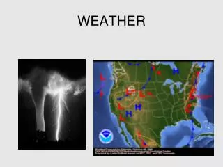
Wind Load Factor Analysis: An Exploratory Approach Snohomish Wind Group Alexi Curelop, Kofi Petty, Sonya Prasertong Geography 469 Spring 2010. Goal and Purpose. How can we calculate and visualize the wind velocity pressure constant (Kzt factor) using the topography of Snohomish County?

E N D
Wind Load Factor Analysis: An Exploratory Approach Snohomish Wind Group Alexi Curelop, Kofi Petty, Sonya Prasertong Geography 469 Spring 2010
Goal and Purpose • How can we calculate and visualize the wind velocity pressure constant (Kzt factor) using the topography of Snohomish County? • Scott Beard, Plans Examiner for City of Tacoma, manually produced Kzt factors for King County and City of Tacoma • Will Rugg, GIS Analyst for Snohomish County Planning and Development Services, interested in how to automate the process via ArcGIS • Our group decided to take on this topic in order to challenge our knowledge of how to apply GIS to real world problems
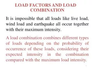
Kzt Factor Significance • Kzt factor when calculated is equivalent to specified wind speeds and is on a scale of 1-2 (eg. Kzt of 2 = 120mph) • It is part of a larger calculation used by planners and architects for determining appropriate areas and materials when developing land • Our project, if successful, could aid Snohomish County in reducing the costs of building and planning for their architects and planners
The Kzt Factor • Kzt = (1 + K1 + K2 + K3)2 • K 1 = determined from table below • K2 = (1 – (|x|/µLh)) • K3= e-γz/Lh Source: American Society of Civil Engineers: Minimum Design Loads for Buildings and Other Structures, 2006
Need-to-Know Questions 1. What are the mid-points of the data? 2. Based off of the mid-points, what is the velocity pressure constant (Kzt factor) of the terrain? 3. How do we model the output information product?
1. What are the mid-points of the data? • Using primarily Spatial Analyst, we were able to calculate the slope of our pilot area to identify base and peak elevations of landforms • We could then create a map of depicting polygons representing these areas, with the centroids for each polygon identified • Tools used: Slope Calculation, Raster Calculator, Convert Raster to Features, Neighborhood Statistics, Zonal Statistics
Based off of the mid-points, what is the velocity pressure constant (Kzt factor) of the terrain? • From here we used the Identify tool to find the exact elevations for the the base and peak polygons of our landforms • We created lines and points to keep track of our calculations, which were recorded in an Excel spreadsheet • Due to the specifications of the Kzt formula, only 4 landforms were able to be selected for calculation • Tools used: Identify tool, Measurement tool, Editor toolbar, Microsoft Excel
3. How do we model the output information product? • We decided the best method of visualization would be colored polygons around our selected landforms, with each color representing a range of Kzt • We decided to use the Waterbodies and Major Roads layers as a means of orienting the audience to our pilot area location • Tools used: Editor toolbar, Add Field tool, Transparency setting
Findings • Due to the specifications of what landforms can be calculated for Kzt, there were only 4 landforms that could be selected • Of these 4 landforms, each seemed to fall on the two extremes of the Kzt factor scale (either 1 or very close to 2). • Kzt Factor Results: Landform A = 2.43 Landform B = 1.99 Landform C = 1.00 Landform D = 1.93
Conclusions • The area we selected contained landforms on both extremes of the Kzt factor scale of 1-2 • We were able to automate the process of calculating peak and base elevations • More time is needed in order to create a more complex pilot study • Python scripting could assist in automating our manual Kzt calculations • Due to our lack of comprehensive knowledge of the particulars of civil engineering formulas, errors in calculations were a possibility
Recommendations • Creating a Python script that can automatically run the manual calculations we performed • Work with individuals that have an in-depth knowledge of both the capabilities of GIS as well as civil engineering background to limit possible errors in calculations • Allow for a study with a longer timeline