Download
1 / 9
90 likes | 200 Views
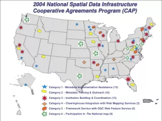
This document outlines the projects funded under the 2008 National Spatial Data Infrastructure (NSDI) Cooperative Agreements Program (CAP). It includes various categories led by different organizations focusing on metadata training, geospatial service-oriented architecture best practices, and data stewardship initiatives across the U.S. Notable projects include efforts by Northern Arizona University in tribal environmental sciences, Indiana University's methods for flood mapping, and initiatives strengthening data stewardship in several states.

E N D
2008 NSDI Cooperative Agreements Program FGDC Coordination Group Meeting March 4, 2008
2008 NSDI CAP Category 1: Metadata Trainer and Outreach Assistance Category Lead – Sharon Shin Up to $25,000 per project, 4 projects • Northern Arizona University, Merriam-Powell Center for Environmental Research • Metadata Training and Outreach for Tribal Environmental Science and Management on the Colorado Plateau • Sonoma Ecology Center • University Metadata Training and Regional Outreach • Innovate!, Inc. • EPA and Partners Geospatial Metadata Implementation Project • George Mason University • Metadata Training for Earth Science and Cyberinfrastructure Communities
2008 NSDI CAP Category 2: Best Practices in Geospatial Service Oriented Architecture (SOA) Category Lead – Doug Nebert Up to $100,000 per project, 3 projects • CubeWerx USA • Role-based Access Control - Best Practices for Geospatial Service Oriented Architecture (SOA) • Indiana University • Geospatial Service Oriented Architecture for Flood Inundation Mapping and Hazard Assessment • Image Matters, LLC • Documenting Best Practices in Geospatial SOA through the Development of a Wetlands Permitting Solution
2008 NSDI CAP Category 3: Fifty States Initiative Category Lead – Milo Robinson Up to $50,000 per project, 8 projects • Colorado • Georgia • Hawai'i • Idaho • Nebraska • Pennsylvania • South Carolina • U.S. Virgin Islands
2008 NSDI CAP Category 5: Building Data Stewardship for The National Map and the NSDI Category Lead – Paul Wiese Up to $50,000 per project, 4 awards • Iowa Geographic Information Council (IGIC) • Building Stewardship Capacity for Structures and Transportation Geodata within the Iowa Geospatial Infrastructure • West Virginia University Research Corporation • Building Stewardship of Integrated Statewide Structure and Transportation Geospatial Databases in West Virginia • Minnesota Land Management Information Center (LMIC) • Minnesota Structures Collaborative – An Initiative to Support the National Map and NSDI • Towson University • Structures Data Themes for Maryland and the National Capital Region
2008 NSDI CAP Category 6: FGDC-Endorsed Standards Implementation Assistance and Outreach (excluding Metadata Standards) Category Lead – Julie Binder Maitra Up to $50,000 per project, 4 awards • Coordinate Solutions • The National Vegetation Classification Standard: Implementation and Outreach for the State of Oklahoma • Delta State University • A Proposed Course and Modular Curriculum For FGDC Standards Adoption and Implementation • North Carolina Center for Geographic Information & Analysis (CGIA) • Implementing the Standard for the U.S. National Grid • University of Montana • Outreach and training on the National Vegetation Classification system to support framework layer development in Montana
The next NSDI CAP season The 2009 NSDI CAP will be open for applications in October 2008.
For more information about the NSDI CAP go to http://www.fgdc.gov/grants/