Download
1 / 18
180 likes | 295 Views
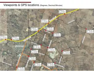
Explore a series of 16 photographic viewpoints captured using a 10-megapixel Olympus digital camera with a 14-42mm lens, focusing on a 42mm equivalent zoom. Each viewpoint is strategically placed along the Sturt Highway and is precisely pegged and numbered for easy reference. GPS coordinates provided in Degrees and Decimal Minutes ensure accurate location identification. This guide is perfect for photography enthusiasts and travelers looking to discover scenic spots along their journey through this region.

E N D
Method 10 Megapixel Olympus Digital Camera with 14-42mm lens Viewpoints taken at 42mm Theory varies as to the zoom which is most equivalent to the human eye (generally 35mm-50mm) Each viewpoint pegged and numbered (as shown) and GPS reference point taken (Degrees, Decimal Minutes)
Viewpoint 1 – Sturt Highway Latitude 34° 27.509’ S Longitude 138° 57.947’ E
Viewpoint 2 – Sturt Highway Latitude 34° 27.610’ S Longitude 138° 58.509’ E
Viewpoint 3 – Sturt Highway Latitude 34° 26.809’ S Longitude 139° 1.293’ E
Viewpoint 4 – Sturt Highway Latitude 34° 26.142’ S Longitude 139° 2.372’ E
Viewpoint 5 – Sturt Highway Latitude 34° 25.382’ S Longitude 139° 3.925’ E
Viewpoint 6 – Cnr Stockwell & Pipeline Rds Latitude 34° 26.957’ S Longitude 139° 2.762’ E
Viewpoint 7 – Cnr Light Pass & Kalimna Rds Latitude 34° 27.949’ S Longitude 139° 1.560’ E
Viewpoint 8 – Cnr Research & Penrice Rds Latitude 34° 28.304’ S Longitude 139° 0.578’ E
Viewpoint 9 – Cnr Light Pass & Angaston Rds Latitude 34° 29.392’ S Longitude 139° 0.862’ E
Viewpoint 10 – Cnr Barossa Valley Hwy & Seppeltsfield Rd Latitude 34° 29.816’ S Longitude 138° 59.114’ E
Viewpoint 11 – Breakneck Hill Rd Latitude 34° 29.480’ S Longitude 139° 2.949’ E
Viewpoint 12 – Moculta Rd Latitude 34° 28.462’ S Longitude 138° 03.724’ E
Viewpoint 13 – Cnr Bastion Hill & Duck Ponds Rd Latitude 34° 26.641’ S Longitude 139° 6.152’ E
Viewpoint 14 – Cnr Research & Angaston Rd Latitude 34° 28.908’ S Longitude 139° 0.328’ E
Viewpoint 15 – Cnr Pipeline & Light Pass Rd Latitude 34° 26.759’ S Longitude 139° 2.067’ E
Viewpoint 16 – Cnr Stockwell & Kalimna Rd Latitude 34° 28.174’ S Longitude 139° 2.255’ E