Download

1 / 16
170 likes | 324 Views
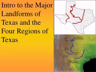
Intro to the Major Landforms of Texas and the Four Regions of Texas. CAPROCK ESCARPMENT. High Plains. Permian Basin. Edwards Plateau. Coastal Plains. BALCONES ESCARPMENT.

E N D
Intro to the Major Landforms of Texas and the Four Regions of Texas CAPROCK ESCARPMENT High Plains Permian Basin Edwards Plateau Coastal Plains BALCONES ESCARPMENT
As we discussed in our “Walk Across Texas”, there are many different landforms in our state. Get out your notes from the “Walk” and write all the LANDFORMS from diagram list on your handout. Add any other landforms you think Texas may have that weren’t on the list. Today, we are going to focus on the vocabulary word escarpment. Texas has two major escarpments that play a large role in the shape of the land of our state.
Major Texas Landforms Escarpment a long steep slope, esp. at the edge of a plateau or separating areas of land at different heights CAPROCK ESCARPMENT High Plains Permian Basin Edwards Plateau Coastal Plains BALCONES ESCARPMENT
BALCONES ESCARPMENT TX Landforms South
CAPROCK ESCARPMENT TX Landforms
Test Your Knowledge Using the handout, write the answers to the questions on the following slides. 1. What is the name of this escarpment?
2. What is the name of this escarpment?
3. This escarpment separates what two major landforms?
4. This escarpment separates the Edwards Plateau from what two major landforms? Edwards Plateau
5. Which two Texas cities are near the Caprock Escarpment? Which escarpment goes through Austin? 6.
Four Regions of Texas The Escarpments help make up the NATURAL BORDERS for the Four Regions of Texas The Four Regions of Texas are: Coastal Plains Region North Central Plains Region Great Plains Region Mountains and Basins Region
Here are the regions on a map. Label them on your map, too. North Central Plains Region Mountains & Basins Region Find Travis County on this map. Put a star on the map where Austin would be (in Travis County). What do you notice about Austin? Which region(s) is it in? Great Plains Region What do you notice about Austin? Which region(s) is it in? Coastal Plains Region
The four regions found in Texas are just part of a larger set of regions found across the United States. What makes a region? The differences in the geography of a place… remember the five things we talked about before the walk? Each region has different locations, landforms, climate, natural vegetation, natural resources.
Sub-Regions of Texas The four Regions of Texas are broken up into 11 Sub-Regions. • The Coastal Plains Region is broken into 5 sub-regions • The North Central Plains Region is broken up into 3 sub-regions
The Great Plains Region is broken up into 3 sub-regions • The Mountains and Basins Region has NO sub-regions
You will be given a Texas map with the sub-regions shown. • You will need to color and label the 11 sub-regions of Texas. • You will also need to use the sub-regions to draw in the 4 regions of Texas. • This assignment will be homework… due the next time you come to class. • Have fun!