Download
1 / 53
680 likes | 1.22k Views
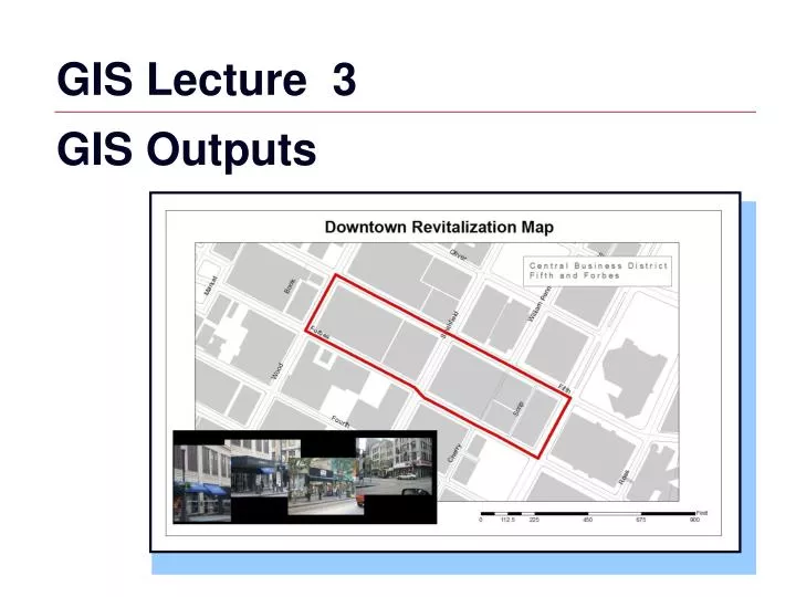
GIS Lecture 3 GIS Outputs. Outline. Map Design Principles Map Audiences Map Layouts Scales Multiple Maps Reports and Graphs on a Layout Exporting Maps Other Map Outputs. Map Design Principles. Design maps for appropriate medium Print vs. electronic

E N D
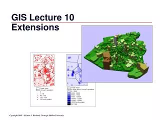
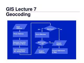
GIS Lecture 3 GIS Outputs
Outline • Map Design Principles • Map Audiences • Map Layouts • Scales • Multiple Maps • Reports and Graphs on a Layout • Exporting Maps • Other Map Outputs
Map Design Principles • Design maps for appropriate medium • Print vs. electronic • Link layouts to map purpose • Planning a layout • Choose appropriate export options
Map Audiences • Map Use: Exploration Presentation • Audience: Trained Analyst General Public
Map Audiences • Map Use: Exploration Presentation • Audience:Trained Analyst General Public • Purpose: Visual Thinking Communication
Map Audiences • Map Use: Exploration Presentation • Audience:Trained Analyst General Public • Purpose:Visual Thinking Communication • Advantages:Graphical Believable
Map Audiences • Map Use: Exploration Presentation • Audience:Trained Analyst General Public • Purpose:Visual Thinking Communication • Advantages:Graphical Believable • Granularity: Fine Coarse
Map Audiences • Map Use: Exploration Presentation • Audience:Trained Analyst General Public • Purpose:Visual Thinking Communication • Advantages:Graphical Believable • Granularity:Fine Coarse • Symbols: Abstract Mimetic capital railroad
Number of Pedestrian Injuries by NeighborhoodCity of Pittsburgh Data obtained from Children’s Hospital of Pittsburgh, 2000-2005
Population under 14 by NeighborhoodCity of Pittsburgh Data obtained from U.S Census, 2000
Injury Rate by NeighborhoodCity of Pittsburgh Data obtained from Children’s Hospital of Pittsburgh, 2000-2005
Map Layouts • Includes all of the elements of a stand alone map • Make the map the largest and most prominent element of the layout • Put a rectangular boundary around the map (called a neat line by cartographers) to help draw attention to it as the central element • Include a map title • The title needs to include information minimally answering the three questions what, where, and when.
Map Layouts (Continued) • Include a legend for symbols placed in the lower-right or left of the layout • No need to label it Legend. Everyone will know what it is (this eliminates “chart junk”) • Include data sources • Ensure legibility • Include a graphic map scale if your audience is not familiar with the area shown • Do not include a north arrow unless the top of your map is not north
Map Layouts (Continued) • Occasionally include other components as needed such as a data table listing, a frequency bar chart for the attribute of a choropleth map, or a photograph
Other Map Elements Neatline, Scale, Additional Text, Photos
Dimensionless Map Scales • ratio that relates a unit of measure on a map to some number of the same units of measure on the earth's surface • 1:25,000 • tells us that 1 unit of measure = 25,000 of the same units on the earth's surface • 1” on the map = 25,000 inches on the earth's surface • one meter or one yard or one kilometer or one mile would represent 25,000 meters or yards or kilometers or miles, respectively, on the earth's surface.
Small Scale Map Large Scale Map Large and Small Scale Maps 1:5,000 is largescale 1:50,000,000 is small scale
Commonly Used Map Scales http://id.water.usgs.gov/reference/map_scales.html
USGS Scales http://www.carolinamapdistributors.com/products/topo/mapscales.htm
Map Units Feet or meter is the map unit for many local government GIS applications
Map Units Inch is the map unit for CAD applications
Scale 1:100,000 Scale
Reports on a Layout Select records to include
Reports on a Layout Generate a report
Reports on a Layout Add report to the layout
Graphs on a Layout Select records to include Create a graph and include on layout
Importing Charts Create graph in excel Copy and Paste object to layout
Exporting Maps Export Images
Exporting Maps Export Images
Exporting Maps Export PDFs
Exporting Maps Copying to PowerPoint • copy individual objects
Exporting Maps Paste into PowerPoint or another application • paste objects individually
Other Outputs • ARCIMS (Internet Mapping Server) • ArcExplorer (Free Viewer) • ArcReader (Free Viewer)
Other Outputs WEB Based Interactive GIS • ArcIMS • http://www.esri.com/software/internetmaps
Other Outputs Municipality of Anchorage, Anchorage Alaska • http://home.muni.org/contents1/maps.cfm