Advancements in Ocean Forecasting: The Bluelink Partnership for Environmental Management
340 likes | 445 Views
This document outlines the collaborative efforts of the Bluelink initiative, involving the Bureau of Meteorology, CSIRO, and the Royal Australian Navy, to enhance ocean forecasting capabilities in the Asian-Australian region. Key components include the Ocean Forecasting Australia Model (OFAM) and the Bluelink Ocean Data Assimilation System (BODAS), which offer integrated analyses and short-range forecasts of ocean conditions. Emphasizing biogeochemical modeling and climate change impacts, this document highlights the importance of sustained observations for effective marine and coastal management.

Advancements in Ocean Forecasting: The Bluelink Partnership for Environmental Management
E N D
Presentation Transcript
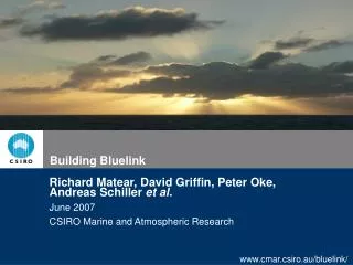
Building Bluelink Richard Matear, David Griffin, Peter Oke, Andreas Schiller et al. June 2007 CSIRO Marine and Atmospheric Research
Introduction • Bluelink: a partnership between the • Bureau of Meteorology, CSIRO and • the Royal Australian Navy
Introduction • Bluelink: a partnership between the • Bureau of Meteorology, CSIRO and • the Royal Australian Navy • Talk Outline • Ocean Forecasting Australia Model, OFAM • Bluelink Ocean Data Assimilation System, BODAS • Bluelink ReANalysis, BRAN • Bluelink High-Resolution Regional Analysis HRRA • Bluelink biological modelling
Minimum resolution: ~100km ~10km resolution Ocean Forecasting Australia Model, OFAM • Global configuration of MOM4 • Eddy-resolving around Australia • 10 m vertical resolution to 200 m, then coarser • Surface fluxes from ECMWF (for reanalyses) … every 10th grid point shown
Bluelink Ocean Data Assimilation System, BODAS • The spatial structure of the covariances are determined by the statistics of the free-running model. Influence of sealevel obs at x
Ensemble OI: vertical projection of surface observations- similar to multiple linear regression Plan view of sea-level increments Cross-section of temperature increments
-> need both SST and SLA. Plan view of sea-level increments Cross-section of temperature bkgnd (grey) & analysis (black-colour)
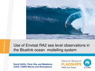
BLUElink Reanalyses Ocean Reanalysis over last 15 years (1992-2006) with focus on Asian-Australian Region Boundary conditions for nested models Physical fields for biogeochemical applications Evaluate strength/weaknesses of ocean monitoring and forecasting systems in Asian-Australian Region (part of GODAE Intercomparison Project) Timor Sea Volume Transports
Relocatable Ocean-Atmosphere Model, ROAM • Automatic implementation via visual interface of hydrodynamic model (MECO) and atmospheric model (RAMS [CSU]) with minimum user input • Forecasts of ocean and atmosphere state out to 3 days • Ocean domains of scales down to 100 km x 100 km with resolution down to 2km • Boundary Conditions: • Lateral ocean boundary information from OFAM • Lateral boundary information for atmosphere from LAPS • Surface atmospheric data for ocean from RAMS
New Application: Downscaling of Climate Change in the Marine Environment (WAMSI + MTSRF) • Present-day climate: BRAN and/or Mk3 simulation (FY 2007/2008) • Future scenarios: Mk3 or other IPCCC simulations (FY 2008/2009) Mk3 or other (~100km): Global Responsibility: CSIRO OFAM (~10km): Australian Region Responsibility: WAMSI Node 2 (CSIRO) SHOC (~1km): SW-WA Resp.: WAMSI Node 1 (CSIRO) ROMS (~1km): Ningaloo Resp.: WAMSI Node 2 (AIMS/UWA) SHOC (~1km): GBR Resp.: MTSRF (AIMS, CSIRO) Multiple Nesting down to sub-km scale Multiple Nesting down to sub-km scale Multiple Nesting down to sub-km scale
ARBGC Model: Nitrogen Cycling in the Photic Zone • Focus on nutrient and carbon cycling in the upper ocean for multi-year simulations • Linked to carbon cycling in the ocean
with SSHA overlay Possible mechanisms of eddy formation and entrainment of shelf waters. SeaWiFS Figure adapted from Pearce & Griffiths 1991 May 6th 2000
Testing the hypothesis in-situ - TIP2000 cruise • TIP2000 Cruise
Biological data assimilation: model calibration • Observed annual mean Chlorophyll • 1D assimilation • 3-D assimilation
Summary (I) • Delivering information on the past, present and future state of the ocean • “Ocean Weather” maps providing daily forecasts and information on the open • and coastal ocean up to 7 days in advance • Outputs: Operational meso-scale nowcasts and short-range forecasts of upper ocean temperature, salinity and current fields • Integrated reanalyses of the ocean state over the last 15+ years. • Public access for registered users: • http://www.marine.csiro.au/dods/nph-dods/dods-data/bluelink • (Marine Environment, Ecosystem, Coastal Management, Climate Research) • BLUElink 2: Improving the current forecast system and moving inshore • (wave forecasting) • New and challenging application outside Bluelink: Downscaling of • Climate Change in the Marine Environment • New Funding for Integrated Marine Observing System (IMOS) - provides an avenue to expand ocean observations (eg. ARGO, Radar systems, Gliders, Moorings )
Summary (II) • Present focus on the physical model but desire to expand to biological models • A BGC model has been coupled to BLUElink physical model • Plan to calibrate biological model by assimilating ocean colour into 1D and 3D biological models • Future Needs • Sustained biogeochemical observations to support BGC modelling and data assimilation • environmental management • fisheries management • carbon management Thank you!
Bluelink Ocean Data Assimilation System, BODAS • Ensemble OI … sequential assimilation technique
Bluelink Ocean Data Assimilation System, BODAS • Ensemble OI … sequential assimilation technique • Assimilates observations of SLA, SST, in situ T and S
Bluelink Ocean Data Assimilation System, BODAS • Ensemble OI … sequential assimilation technique • Assimilates observations of SLA, SST, in situ T and S • To constrain the model to match reality, then make a forecast
Bluelink Ocean Data Assimilation System, BODAS • Multivariate assimilation system: • sea level obs correct h,T,S,U,V Single point assimilation …
HRRA - Gridded altimetry and SST,statistically projected to depth:
Mixed Layer Depth and Phytoplankton Phytoplankton refects a balance between growth and grazing
Summary (I) • Delivering information on the past, present and future state of the ocean • “Ocean Weather” maps providing daily forecasts and information on the open • and coastal ocean up to 7 days in advance • Outputs: Operational meso-scale nowcasts and short-range forecasts of upper ocean temperature, salinity and current fields • Integrated reanalyses of the ocean state over the last 15+ years. • Public access for registered users: • http://www.marine.csiro.au/dods/nph-dods/dods-data/bluelink • (Marine Environment, Ecosystem, Coastal Management, Climate Research) • BLUElink 2: Improving the current • forecast system and moving inshore • (wave forecasting) • New and challenging application • outside Bluelink: Downscaling of • Climate Change in the Marine • Environment (MTSRF and WAMSI)
Summary (II) • BGC model simulations coupled to BLUElink physical model • Data Assimilation into 1D and 3D biological model • Sustained biogeochemical observations to support BGC modelling and assimilation • environmental management • fisheries management • carbon management Thank you!