Download
1 / 20
200 likes | 304 Views
Explore the role and challenges of WGSF in monitoring, validating, and improving climate model components, including ocean-atmosphere forcing functions and atmospheric variables. Learn about the key processes, biases, and impacts on climate predictability.

E N D
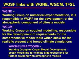
WGSF links with WGNE, WGCM, TFSL WGNE – Working Group on numerical experimentation, it is responsible in WCRP for the development of the atmospheric component of climate models WGCM – Working Group on coupled modelling, responsible for the development of requirements for the comprehensive model tools which allow for the realistic present and forced climate simulations WGCM/CLIVAR WGOMD – Working Group on Ocean Model Development – ocean modelling for climate diagnostics and for further coupling with atmospheric models
AMIP & CMIP AMIP1/AMIP2 – Comprehensive validation and intercomparison of atmospheric models ran with the standard requirements and forcing functions. 23 modelling groups, fluxes are still poorly validated, SURFA… CMIP1/CMIP2 – establishing a validation framework for the coupled models ran with the standard perfomance, both PC and SR
Where is the role of WGSF? • WGNE, WGCM, WGOMD: • forcing functions for ocean/atmosphere • modelling; • assessments of the strengths and • weaknesses of particular NWP flux products; • flux fields/forcing formulations for ocean • reanalyses;
Sources of the global- and basin-scale flux field products:
A typical NWP air-sea flux product Operational atmospheric GCM Data assimilation system Short-term forecast: 1 to 6 hours SST analysis • Prognostic variables: • (time-step forecasts) • air temperature (2m), • specific humidity (2m), • wind speed (10m), • sea level pressure, • cloud cover Physical parameterizations • Diagnostic variables: • (time-step averages) • sensible heat, • Latent heat, • SW radiation, • LW radiation, • wind stress Our choice Fluxes, recomputed from NWP prognostic variables Directly use the fluxes, diagnosed by the NWP
Challenges for WGSF • Global/regional energy budgets; • Parameterizations, their assessments and • validation; • Use of NWP for estimation of sampling errors • in VOS and satellite fluxes; • Role of fluxes in driving climate system, in • particular, the extent to that surface fluxes • can help to establish predictability limits; • Variability studies, climate modes, key-regions • and key-processes.
Global ocean heat balance derived from different data sources The largest variations are observed for the latent flux and net SW (up to 20 W/m2) Global heat balance in VOS products is imbalanced by 30 W/m2 (ocean gets more heat), while in the NWP products imbalances are within ±5W/m2.
Example: sources of biases in NWP precipitation • Strong impact of the spin-up on precipitation in short-range forecasts; • Running precipitation parameterizations on reduced Gaussian grid; • An incorrect parameterization of horizontal moisture diffusion, • unrealistic cloud-top cooling and unrealistically high oceanic albedo • in NCEP1 (all three have been corrected along in NCEP2); • Gibbs oscillations in the orography of NCEP1 (was smoothed in • NCEP2). Different data assimilation inputs: • NCEP1 – Radiosondes, the dropsondes and pibals, marine and • continental winds from different sources • NCEP2 – Xie and Arkin (1997) five day mean rainfall for tor • adjustment of soil moisture • ERA-40 – VTPR (Vertical Temperature Profile Radiometer) and TOVS • (Television Infrared Operational Satellite (TIROS) Operational • Vertical Sounder) starting from 1972 and ERS winds (from 1991)
Sampling biases in VOS fluxes
Kushnir et al. (2002), Lisa Goddard: analysis of 10 GCM integrations forced with global SST ratio of SST-determined SLP variance (potential predictability) Dan Hodson and Rowan Sutton, 2002: Six simulations with the HadAM3 AGCM of the period 1871-1999 The internal SLP variability vs the SST-forced response
The ERA-40-WAM system • Operational ECMWF system (IFS) • TL159, 60 layers • 3DVAR: • COADS, GTS, satellites, hist. data, .... • interactive determination of Charnock parameter (= sea • surface roughness) • coupled to WAM (1.5°) • => Waves Global mean SWH ERA40-WAM (by courtesy of Andreas Sterl and Sofia Caires)
GEWEX: • Provides Guidance on How to Initialize Land Surface • Proposes/Implements Diagnostic Studies and Numerical • experiments: Understanding Land Surface Feedbacks • CliC: • Provides Guidance on How to Initialize Cryosphere • Proposes/Implements Diagnostic Studies and Numerical • experiments • CLIVAR: • Provides Guidance on How to Initialize Ocean • Proposes/Implements Diagnostic Studies and Numerical • experiments • SPARC: • Provides Guidance on How to Prescribe Atmospheric composition • Provides Guidance on How to Initialize Stratosphere • Proposes/Implements Diagnostic Studies and Numerical • experiments Task Force for Seasonal Prediction: Interactive Atmosphere-Ocean-Land-Ice Prediction Experiment
Interactive Atmosphere-Ocean-Land-Ice Prediction Experiment • Predictability Diagnostic (Example) • Limit of Predictability when the Forecast Ensemble Distribution same as Total Forecast Climate Distribution Free Running Model PDF Initial Condition (t=0) PDF t=limit of Predictability?
Previous climate New climate More record extreme rainfall and flooding Probability of occurrence Moderate Dry Wet IPCC, 2001
TSSL and WGSF TSSL - is established to facilitate multidisciplinary study of the sea level change (JSC-26, special topic) Surface fluxes, first of all E-P, affecting water balance, and ocean heat/fresh water uptakes, affecting steric changes, is a critical factor of sea-level variability
STERIC SEA LEVEL TRENDS (1955-1995) Cabanes et al., 2001
Topex/Poseidon (1993-1998) SEA LEVEL TRENDS FOR 1993-1998 (mm/yr) Upper map : Observed (Topex/Poseidon) Bottom map: Computed (thermal expansion) Thermal expansion (1993-1998) - -27 mm/yr +27 Cabanes et al., 2001
WGSF Target actions: • SURFA; • AMIP parameterization testbed – cross- • pollination of parameterizations developed • from field experiments and used in NWP; • NWP fluxes and biases and in VOS/satellite • flux products; • Ocean reanalyses – • (i) better established forcing functions, • (ii) tools and requirements for the • reanalyses output diagnostics; • Climate modes and predictability limits; • TFSL – assessment of the role of sea-air • fluxes.