Download
1 / 33
330 likes | 462 Views
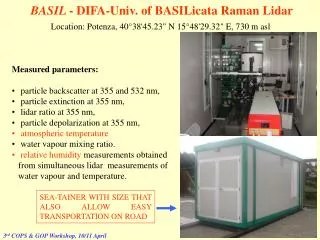
BASIL - DIFA-Univ. of BASILicata Raman Lidar. Location: Potenza, 40°38'45.23" N 15°48'29.32" E, 730 m asl. Measured parameters: particle backscatter at 355 and 532 nm, particle extinction at 355 nm, lidar ratio at 355 nm, particle depolarization at 355 nm, atmospheric temperature

E N D
BASIL - DIFA-Univ. of BASILicata Raman Lidar Location: Potenza, 40°38'45.23" N 15°48'29.32" E, 730 m asl • Measured parameters: • particle backscatter at 355 and 532 nm, • particle extinction at 355 nm, • lidar ratio at 355 nm, • particle depolarization at 355 nm, • atmospheric temperature • water vapour mixing ratio. • relative humidity measurements obtained from simultaneous lidar measurements of water vapour and temperature. SEA-TAINER WITH SIZE THAT ALSO ALLOW EASY TRANSPORTATION ON ROAD 3rd COPS & GOP Workshop, 10/11 April
BASIL LASER: Nd:YAG laser (Quanta Systems – SYL 202) Max. Pulse Energy@ 355nm 250 mJ Maximum repetition rate 20Hz Beam divergence 0.5 mrad Pulse duration 5 ÷ 6 ns RECEIVING SYSTEM: Newtonian telescope Primary mirror diameter 0.4 m Combined focal length 1.8 m Field of view 0.5 mrad DETECTORS: photomultipliers Photocathode = Bialkali Quantum efficiency @ 355 nm= 20 % Gain = 2x10⁶ ACQUISITION: photon counting mode Minimum dwell time 100 ns Bandwidth 125 MHz SPECTRAL SELECTION: based on Interference Filters Aerosol/clouds N2 H2O T(LoJ) T(HiJ) Wavelength (nm) 532 355 387 407 354.1-5 352.5-353.5 Bandwidth (nm) 1.0 0.5 1.0 0.3 0.3 1.0 Out-of-band blocking 10-6 10-6 10-10 10-10 10-6 10-6 CW Transmission (%) 50 30 30 30 30 30 Optimized for both night-time and day-time operation Vertical pointing capability only 3rd COPS & GOP Workshop, 10/11 April
BASIL Measurement precision Water Vapor Mixing Ratio DIFA-Univ. Basilicata 5 minute 150 meters Dt=5 min, Dz=150 meters • day <5% up to 2 km • night <2% up to 2 km, <20% up to 6km Up to 13 km with 30 min time integration 3rd COPS & GOP Workshop, 10/11 April
BASIL Measurement precision Temperature BASIL BASIL Dt = 5 minute Dz = 150 meters Dt=5 min, Dz=150 meters • day < 2 K up to 2 km • night <1 K up to 2 km, <2 K up to 7 km Up to 26 km with 1h30 min time integration Up to 36 km with ≈ 8h min time integration 3rd COPS & GOP Workshop, 10/11 April
12 11 10 9 8 7 6 5 4 3 2 BASIL - DIFA - Univ. of Basilicata Lidar (Lat: 40°38'45.23" N, Long: 15°48'29.32" E, Site elevation: 730 m) 06-07 September 2004 – Particle backscattering at 355 nm (m-1 sr-1) Height a.s.l. (m) 17:32 00:33 19:52 22:13 02:55 DT = 1 min, Dz = 30 m GMT Time 3rd COPS & GOP Workshop, 10/11 April
12 11 10 9 8 7 6 5 4 3 2 BASIL - DIFA - Univ. of Basilicata Lidar (Lat: 40°38'45.23" N, Long: 15°48'29.32" E, Site elevation: 730 m) 06-07 September 2004 – Water vapour mixing ratio (g/Kg) Height a.s.l. (m) 17:32 00:33 19:52 22:13 02:55 GMT Time DT = 1 min, Dz = 30 m 3rd COPS & GOP Workshop, 10/11 April
12 11 10 9 8 7 6 5 4 3 2 BASIL-DIFA - Univ. of Basilicata Lidar (Lat: 40°38'45.23" N, Long: 15°48'29.32" E, Site elevation: 730 m) 06 September 2004 – Particle extinction at 355 nm (m-1) Height a.s.l. (m) 17:32 00:33 19:52 22:13 02:55 GMT Time DT = 1 min, Dz = 300 m 3rd COPS & GOP Workshop, 10/11 April
12 11 10 9 8 7 6 5 4 3 2 BASIL-DIFA - Univ. of Basilicata Lidar (Lat: 40°38'45.23" N, Long: 15°48'29.32" E, Site elevation: 730 m) 06 September 2004 – Extinction-to-backscatter ratio at 355 nm (sr) Height a.s.l. (m) 17:32 00:33 19:52 22:13 02:55 GMT Time GMT Time Lidar ratio 20-25 sr Typical for cirrus clouds & altostratus DT = 1 min, Dz = 300 m Lidar ratio 40-80 sr Typical for aerosols in PBL
BASIL-DIFA - Univ. of Basilicata Lidar (Lat: 40°38'45.23" N, Long: 15°48'29.32" E, Site elevation: 730 m) 06 September 2004 – Temperature (K) 11 10 9 8 Height a.s.l. (m) 7 6 5 4 3 2 17:32 00:33 19:52 22:13 02:55 GMT Time GMT Time DT = 5 min, Dz = 300 m 3rd COPS & GOP Workshop, 10/11 April
12 11 10 9 8 7 6 5 4 3 2 BASIL- DIFA - Univ. of Basilicata Lidar (Lat: 40°38'45.23" N, Long: 15°48'29.32" E, Site elevation: 730 m) 06 September 2004 – Relative humidity (with respect to water) % Height a.s.l. (m) 17:32 00:33 19:52 22:13 02:55 GMT Time GMT Time Upper tropospheric humidification due to cirrus sublimation DT = 10 min, Dz = 300 m
BASIL (Lat: 40°38'45.23" N, Long: 15°48'29.32" E, Site elevation: 730 m) 01-03 October 2005 – Water Vapour mixing ratio Dry stratospheric intrusion episode associated with aof tropopause folding event (g/Kg) 12730 10330 7930 Height a.s.l. (m) 5530 Log Scale 3130 730 18:05 02:35 10:25 02:15 18:15 GMT Time 01 October 03 October 02 October DT=10min; Dz=75m <5km 150m >5km 3rd COPS & GOP Workshop, 10/11 April
1-2 October 2005 – Water Vapour mixing ratio (g/kg) 12730 10330 7930 Height a.s.l. (m) 5530 Log Scale 3130 730 01:15 04:50 08:25 18:05 21:40 UT Time 3rd COPS & GOP Workshop, 10/11 April
1-2 October 2005 – Atmospheric temperature (K) 12730 10330 7930 Height a.s.l. (m) 5530 3130 730 01:15 04:50 08:25 18:05 21:40 UT Time 3rd COPS & GOP Workshop, 10/11 April
1-2 October 2005 – Relative humidity (%) 12730 10330 7930 Height a.s.l. (m) 5530 Log Scale 3130 730 01:15 04:50 08:25 18:05 21:40 UT Time 3rd COPS & GOP Workshop, 10/11 April
WATER VAPOUR MIXING RATIO DT=10min; Dz=150m
Data provided for assimilation purposes: Specific humidityAtmospheric temperature • Based on the requests from the data assimilation people, • 10 minute integration time (6 profiles per hour) This allows to get a measuement error not exceeding 20 % up to approx. 7-8 km at night and up to approx. 4 km in daytime. Vertical resolution for water vapour: 75 mup to5 km 150 m above 5 km Vertical resolution for temperature 600 m Data have been delivered in NetCDF format. 3rd COPS & GOP Workshop, 10/11 April
Univ. of Basilicata Lidar (Lat: 40°38'45.23" N, Long: 15°48'29.32" E, Site elevation: 730 m) 11-12 October 2005 – Water Vapour mixing ratio (g/Kg) 12730 10330 7930 Height a.s.l. (m) 5530 3130 730 17:55 22:55 04:15 13:35 14:55 09:25 GMT Time 12 October 11 October DT=10min; Dz=75m <5km 150m >5km
Univ. of Basilicata Lidar (Lat: 40°38'45.23" N, Long: 15°48'29.32" E, Site elevation: 730 m) 11-12 October 2005 – Water Vapour mixing ratio (g/Kg) 12730 10330 7930 Height a.s.l. (m) 5530 Log Scale 3130 730 17:55 22:55 04:15 13:35 14:55 09:25 GMT Time 12 October 11 October DT=10min; Dz=75m <5km 150m >5km
Univ. of Basilicata Lidar (Lat: 40°38'45.23" N, Long: 15°48'29.32" E, Site elevation: 730 m) 11-12 October 2005 – Relative error (%) 12730 10330 7930 Height a.s.l. (m) 5530 Log Scale 3130 730 17:55 22:55 04:15 13:35 14:55 09:25 GMT Time 12 October 11 October DT=10min; Dz=75m <5km 150m >5km
WATER VAPOUR MIXING RATIO TEMPERATURE
Univ. of Basilicata Lidar (Lat: 40°38'45.23" N, Long: 15°48'29.32" E, Site elevation: 730 m) 11-12 October 2005 – Temperature (K) 12730 10330 7930 Height a.s.l. (m) 5530 3130 730 17:55 22:55 04:15 14:55 GMT Time 12 October 11 October DT=10min; Dz=600 m
Univ. of Basilicata Lidar (Lat: 40°38'45.23" N, Long: 15°48'29.32" E, Site elevation: 730 m) 11-12 October 2005 – Temperature error (K) 12730 10330 7930 Height a.s.l. (m) 5530 3130 730 17:55 22:55 04:15 14:55 GMT Time 12 October 11 October DT=10min; Dz=600 m
Univ. of Basilicata Lidar (Lat: 40°38'45.23" N, Long: 15°48'29.32" E, Site elevation: 730 m) 01-03 October 2005 – Water Vapour mixing ratio Stratospheric dry air intrusion associated with aof tropopause folding event (g/Kg) 12730 10330 7930 Height a.s.l. (m) 5530 3130 730 18:05 02:35 10:25 02:15 18:15 GMT Time 01 October 03 October 02 October DT=10min; Dz=75m <5km 150m >5km PV-streamer event
Univ. of Basilicata Lidar (Lat: 40°38'45.23" N, Long: 15°48'29.32" E, Site elevation: 730 m) 01-03 October 2005 – Relative error (%) 12730 10330 7930 Height a.s.l. (m) 5530 3130 730 18:05 02:35 10:25 02:15 18:15 GMT Time 01 October 03 October 02 October DT=10min; Dz=75m <5km 150m >5km
Stratospheric dry air intrusion associated with aof tropopause folding event 1 October 2005 – water vapour mixing ratio (g/kg) 12730 10330 7930 Height a.s.l. (m) 5530 3130 730 01:12 04:49 08:26 17:48 21:36 GMT Time PRELIMINARY DATA DT=1min Dz=30m
Stratospheric dry air intrusion associated with aof tropopause folding event PRELIMINARY DATA °K 1 October 2005 – Temperature 12730 10330 TO BE CORRECTED FOR PILE_UP 7930 Height a.s.l. (m) 5530 3130 Same trend on the temperature and humidity map The dry layer tongue is associated with lower temperatues 730 01:12 04:49 08:26 17:48 21:36 GMT Time DT=5min Dz=300m
Univ. of Basilicata Lidar (Lat: 40°38'45.23" N, Long: 15°48'29.32" E, Site elevation: 730 m) 26-28 October 2005 – Water Vapour mixing ratio (g/Kg) 12730 10330 7930 Height a.s.l. (m) 5530 FOG 3130 730 17:13 00:55 00:12 8:38 16:24 GMT Time PRELIMINARY DATA DT=3min Dz=120m
Wave structures underlieing thick clouds and appearing to be associated with the approachig of the cloud system 12 September 2005 – Water Vapour mixing ratio (g/Kg) 6730 5530 THICK CLOUDS 4330 3130 1930 730 14:52 16:12 19:24 22:17 waves GMT Time PRELIMINARY DATA DT=1min Dz=30m 12 Oct,10:30-12 Oct, 22:20 GMT
STRONG CONVECTIVE ACTIVITY 19-20 October 2005 – Water Vapour mixing ratio (g/Kg) 12730 10330 7930 Height a.s.l. (m) 5530 3130 STRONG CONVECTIVE ACTIVITY 730 10:28 14:17 03:44 21:00 GMT Time PRELIMINARY DATA DT=3min Dz=120m
Cloud formation possibly associated with the propagation of a gravity wave 27-28 September 2005 – Water Vapour mixing ratio (g/Kg) 12730 10330 7930 5530 CLOUDS 3130 730 wave 14:57 19:15 23:36 03:54 06:40 GMT Time PRELIMINARY DATA DT=1min Dz=30m 27 Sept,14:55-28 Set, 18:15 GMT
Cloud formation possibly associated with the propagation of a gravity wave 27-28 September 2005– Particle backscattering at 355 nm (m-1 sr-1) 12730 10330 7930 5530 CLOUDS 3130 730 wave 14:57 19:15 23:36 03:54 06:40 GMT Time PRELIMINARY DATA DT=1min Dz=30m
Stratospheric dry intrusion event probably associated with aof tropospheric folding event (m-1 sr-1) 1 October 2005– Particle backscattering at 355 nm 12730 10330 7930 Height a.s.l. (m) 5530 3130 730 17:48 GMT Time PRELIMINARY DATA DT=1min Dz=30m