Download
1 / 51
510 likes | 535 Views
Learn about the THORPEX Interactive Global Ensemble (TIGGE) and how it can improve tropical cyclone forecasting. Explore the objectives, ensemble forecasting, probabilistic forecasting, and forecast products of TIGGE.

E N D
The THORPEX Interactive Global Ensemble (TIGGE) Multi-model ensembles and Tropical cyclone forecasting Richard Swinbank, with thanks to the GIFS-TIGGE working group, THORPEX IPO and Met Office & other colleagues Ensemble TC forecasting workshop, Nanjing, 14-16 December 2011
TIGGE and ensemble forecast products • TIGGE • Objectives • TIGGE archive • Ensemble forecasting • Probabilistic forecasting • Use of multi-model ensembles • Forecast products • Plans for development of Global Interactive Forecast System • Developing links with CBS/SWFDP • Tropical cyclone forecast products
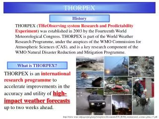
TIGGETHORPEX Interactive Grand Global Ensemble • A major component of THORPEX: a World Weather Research Programme to accelerate the improvements in the accuracy of 1-day to 2-week high-impact weather forecasts • GEO task WE-06-03 – “TIGGE and the Development of a Global Interactive Forecast System for Weather” Objectives: • Enhance collaboration on ensemble prediction, both internationally and between operational centres & universities. • Facilitate research on ensemble prediction methods, especially methods to combine ensembles and to correct systematic errors • Enable evolution towards a prototype operational system, the “Global Interactive Forecast System”
TIGGE data • Ten of the leading global forecast centres are providing regular ensemble predictions to support research on predictability, dynamical processes and the development of probabilistic forecasting methods. • TIGGE data is made available for research after a 48-hour delay. Near real-time access may be granted for specific projects through the THORPEX International Project Office.
Summary of TIGGE database (late 2010) * Delivery of BoM data currently suspended; KMA resumed Aug 2011
TIGGE Archive Usage (NCAR + ECMWF)
Information about TIGGE • Major Article in BAMS • New leaflet to publicise TIGGE to researchers • Contribution in GEO book “Crafting Geoinformation” • Tropical cyclone case study in WMO Bulletin • TIGGE website
TIGGE Research Following the successful establishment of the TIGGE dataset, the main focus of the GIFS-TIGGE working group has shifted towards research on ensemble forecasting. Particular topics of interest include: • a posteriori calibration of ensemble forecasts (bias correction, downscaling, etc.); • combination of ensembles produced by multiple models; • research on and development of probabilistic forecast products. TIGGE data is also invaluable as a resource for a wide range of research projects, for example on dynamical processes and predictability. Up to the end of 2010, 43 articles related to TIGGE have been published in the scientific literature
Ensemble forecasting Deterministic Forecast Initial Condition Uncertainty X Analysis Climatology time Forecast uncertainty
The atmosphere is a chaotic system: “… one flap of a seagull’s wing may forever change the future course of the weather”, (Lorenz, 1963) Ensemble forecasting - effect of Chaos • Up to about 3 days ahead we can usually forecast the general pattern of the weather quite accurately • Beyond 3 days Chaos becomes a major factor • Tiny errors in how we analyse the current state of the atmosphere lead to large errors in the forecast – these are both equally valid 4-day forecasts! • Fine details (eg rainfall) have shorter predictability With acknowledgements to Ken Mylne for general Ensemble Forecasting slides
Lorenz Model – a simple chaotic system • Variations in predictability can be illustrated using the Lorenz (1963) model: Simple non-linear system.
Ensemble Forecasting in the Lorenz Model 1. Predictable - deterministic OK 2. Predictable at first - probability OK 3. Unpredictable climatology OK Thanks to Tim Palmer, ECMWF
Ensemble Forecasting • The aim of ensemble prediction system is to represent the uncertainty in the state of the NWP model at all stages through the forecast range • Each ensemble member is designed to sample a PDF representing uncertainties in the model state. The PDF is usually represented by a control run plus many perturbed forecasts. • Initial condition perturbations are designed to represent uncertainties in the initial analysis – closely linked to data assimilation. These grow with time as a result of the chaotic nature of model dynamics. • The uncertainty in forecasts also grows as a result of model error. This effect may be represented by perturbing model physics – e.g. stochastic physics schemes.
Examples of comparison of ensemble spread & error (from 2010 MOGREPS upgrade) Compare Red – old Blue − new Note: Ensemble spread is less than RMS errors New system both reduces RMS error & increases spread Under-spread in surface temperature exaggerated because of representivity errors (point observations not representative of grid-square averages)
Under-dispersive forecast Deterministic Forecast Real forecast uncertainty Initial Condition Uncertainty Estimated forecast uncertainty X The ensemble may capture reality less often than it should. Dangerous - false sense of security! Analysis time
What makes a good ensemble? Resolution – ability to distinguish between different events. Reliability – the forecast probabilities match the associated observed frequencies. Calibration – apply post-processing so that the statistics match those of a reference dataset. This might include bias-correction and variance adjustment. Observed The observed track should lie within the ensemble.
Met Office Multi-Model Ensemble One approach to improving the calibration is to use multi-model ensembles NCEP 21 Member 3 variables: MSLP 2m Temp 500mb Height ECMWF 51 Member Met Office 24 Member Met Office MME results courtesy Christine Johnson
Reliability Diagrams UKMO ECMWF Probability that 2m temperature is greater than the climatological mean at T+240. Globally averaged. Multimodel NCEP Multi-model gives better reliability and reduced sharpness.
1 day 5 day Brier Skill Scores Brier Probability of 2m temperature greater than climatological mean. Multi-model gives improvement in reliability and resolution at all lead times. Reliability Resolution
Dissimilarity of ensembles D has large values (high dissimilarity, red) if the between-model variance is large compared to the mean-square-error of the multi-model mean. mslp temp D+2 D+2 D+10 D+10
Multi-model ensemble forecast Deterministic Forecast real forecast uncertainty Initial Condition Uncertainty Estimated forecast uncertainty X Use of multi-model ensembles can improve the sampling of forecast uncertainty Analysis time
Multi-model ensemble forecasts of T850 Demonstrates benefit of multi-model ensemble, provided that the most skilful models are used. Renate Hagedorn, ECMWF
Multi-model ensemble compared with reforecast calibration • Reforecast calibration gives comparable benefit to multi-model ensemble • Choice of verification data set (in this case, ERA-Interim) could have subtle but significant effect on relative benefits • Calibration could further enhance benefit of multi-model ensemble Renate Hagedorn
Precipitation forecasts over USA • 24 hour accumulations, data from 1 July 2010 to 31 October 2010. • 20 members each from ECMWF, NCEP, UK Met Office, Canadian Meteorological Centre. • 80-member, equally weighted, multi-model ensemble verified as well. • Verification follows Hamill and Juras (QJ, Oct 2006) to avoid over-estimating skill due to variations in climatology. • Conclusions: • ECMWF generally most skillful. • Multi-model beats all. Tom Hamill
Summary - EPS & multi-model ensembles • Ensembles are valuable for forecasting the risks of exceeding thresholds (e.g. for high-impact weather events). • But forecasts often need calibration to correct both biases and variability (e.g. to correct under-estimates of forecast spread). • The best approach is to address the systematic errors, i.e. reduce model biases and improve the representation of model errors in the EPSs. • That is a long-term goal. In the mean time…. • Use of multi-model ensembles is a pragmatic approach that reduces calibration errors, especially where models have similar skill but different types of systematic error • Reforecasts (forecasts of past cases with current NWP models) can be used to estimate, and then correct, model biases
Towards the Global Interactive Forecast System (GIFS) • Many weather forecast situations are low probability but high risk – unlikely but potentially catastrophic. Probabilistic forecasting is a powerful tool to improve early warning of high-impact events. • The objective of the GIFS is to realise the benefits of THORPEX research by developing and evaluating probabilistic products to deliver improved forecasts of high-impact weather. • GIFS-TIGGE WG has initiated a GIFS development project to develop & evaluate products, focused on • Tropical cyclones • Heavy precipitation • Strong winds
Tropical cyclones • As a first step, the GIFS-TIGGE working group set up a pilot project for the exchange of real-time tropical cyclone predictions using “Cyclone XML” format. Example of combined TC track forecasts (Met Office + ECMWF)
GIFS links with SWFDP • GIFS will collaborate with WMO Severe Weather Forecast Demonstration Project (SWFDP) and other FDPs and RDPs • to ensure that products address needs of operational forecasters and end users; • to provide an environment for the evaluation of prototype products. • GIFS will use global-regional-national cascade pioneered by the SWFDP. No single “GIFS centre”. • Use of web-enabled technology for generation and distribution of products.
Tropical cyclone products:Examples from Met Office • Uses Julian Heming’s code to identify and track tropical cyclones (TC), originally developed for the deterministic global Unified Model. • Tropical Cyclones (TCs) are identified where 850hPa relative vorticity (RV) maxima are greater than a threshold • For TC tracking, use search radius of 4 degrees for analysis and 5 degrees for forecast positions • Identified storms that do not match with a named storm or a TC identified at a previous time are counted as TC genesis Met Office TC products courtesy Pier Buchanan, Helen Titley and Julian Heming
MOGREPS-15 products for Ma-On, 12Z Friday 14th July 2011. • Left hand plot: 24 ensemble tracks • Middle plot: strike probability – probability that the storm will be within 75 miles within thhe next 15 days. • Right hand plot: MOGREPS ensemble mean (blue), control (cyan), previous observations (red) and deterministic track (green)
Products for named and potential storms on a basin by basin basis.
StormTracker Ma-On, 12Z Friday 14th July 2011. • Black – previous track • White – deterministic model forecast • Purple UKMO ensemble mean, mustard ECMWF ensemble mean and pink NCEP GEFS ensemble mean.
TOMAS: MOGREPS-15 12Z North Atlantic forecast on Wednesday 27th October 2010.
Comparison of deterministic forecast with MOGREPS-15 ensemble mean
Tropical cyclone productsfrom MRI/JMA http://tparc.mri-jma.go.jp/cyclone/
New tropical cyclone product:Strike probability time-series at a city Tetsuo Nakazawa
Warnings of heavy precipitation • Similar products also available for • hot & cold temperatures, • strong winds Prototype product courtesy Mio Matsueda
Case 1: heavy rainfall by cyclone YASI (Feb. 2011) + 7-day forecast TRMM daily precipitation exceeds the TRMM's 95th percentile.
Case 1: heavy precipitation by cyclone YASI + 6-day forecast
Case 1: heavy rainfall by cyclone YASI (Feb. 2011) + 5-day forecast
Case 1: heavy rainfall by cyclone YASI (Feb. 2011) + 4-day forecast
Case 1: heavy rainfall by cyclone YASI (Feb. 2011) + 3-day forecast
Case 1: heavy rainfall by cyclone YASI (Feb. 2011) + 2-day forecast
Case 1: heavy rainfall by cyclone YASI (Feb. 2011) + 1-day forecast
Other possible visualisation: combined warnings Prototype product courtesy Mio Matsueda
ICDM workshop • Workshop on Dynamics and Predictability of High-Impact Weather Events and Climate Extremes • Kunming, China 6-9 August 2012 • Organised by IAMAS International Commission on Dynamical Meteorology • Sponsored by WWRP, WCRP, IUGG, IAMAS, Chinese IUGG committee, CAS, NSFC, LASG/IAP, Nanjing University & research projects. • Further information (first announcement) available from me. Website: http://icdm2012.csp.escience.cn