Download
1 / 14
140 likes | 268 Views
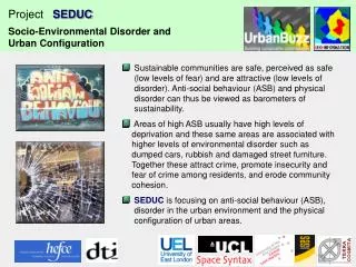
Project SEDUC. Socio-Environmental Disorder and Urban Configuration. Data Geocoding Enhanced Geocoding Toolkit. ~50%. Project SEDUC. Socio-Environmental Disorder and Urban Configuration. Geocoding Issues. Incident Location. Analysis. Geocoding. Crime reports.

E N D
Project SEDUC Socio-Environmental Disorder and Urban Configuration Data Geocoding Enhanced Geocoding Toolkit
~50% Project SEDUC Socio-Environmental Disorder and Urban Configuration Geocoding Issues Incident Location Analysis Geocoding Crime reports Enhanced Geocoding Toolkit FLARE data
Project SEDUC Socio-Environmental Disorder and Urban Configuration Enhanced geocoding ~90% Standard geocoding ~50% Details of pan-London study in: Brimicombe A..J.; Brimicombe, L..C. & Li, Y. (2007) Improving geocoding rates in preparation for crime data analysis. International Journal of Police Science and Management 9: 80-92
Address point data PAF data Project SEDUC Socio-Environmental Disorder and Urban Configuration Enhanced Geocoding Toolkit: a multi-level approach – from L1 to L4 Pre-Process Cleansing Functions: removal of non-address data, postcode cleaning etc. L1 Standard Address Point Geocoding (Matchcode used for this procedure) L1 Level Batch process to address level Yes Geocoded to level L1 Is the record geocoded? No
street junction data derived from OS ITN gazetteer data CodePoint data Project SEDUC Socio-Environmental Disorder and Urban Configuration Yes Geocoded to level L1 Is the record geocoded? No L2 & L3 Advanced Geocoding geocode using other location information e.g junction data, station name etc. L2 Level Yes Geocoded to level L2 Is the record geocoded? No L3 Level geocode using postcode information Yes Geocoded to level L3 Is the record geocoded? No
street point data derived from OS ITN CAD-ref data Project SEDUC Socio-Environmental Disorder and Urban Configuration L4 Geocoding at street level Geocoding using CAD-ref and street name L4 Level No Yes Geocoded to level L4 Is the record geocoded? Move geocoded database Add Validation code End of process
Project SEDUC Socio-Environmental Disorder and Urban Configuration Enhanced Geocoding Toolkit Brimicombe A.J. Brimicombe, L. Li, Y. 2007 Improving geocoding rates in preparation for crime data analysis. International Journal of Police Science and Management. 9: 80-92 ISSN 1461-3557
Project SEDUC Socio-Environmental Disorder and Urban Configuration Batch cleaning with this toolkit will increase geocoding rateand beconsistentfor the bulk of the data 90,904 records of all crime
Project SEDUC Socio-Environmental Disorder and Urban Configuration Newham Time period: Two years January 2006 to December 2007 Total records in data set: 70,812 Anti-social behaviour records: 48,698 Variables: ASB incident type; date, time Geo-coded records: 98% (47,617 records) ASB incident types: 160 in total with sub-codes - drunken behaviour - Threatening/violent behaviour - Vandalism - drug related - Fly tipping - Graffiti - Hooliganism/Loutish behaviour - Intimidation - Noising neighbours - Harassment - Problematic congregation
Project SEDUC Socio-Environmental Disorder and Urban Configuration
Project SEDUC Socio-Environmental Disorder and Urban Configuration Tower Hamlets Time period: Two years January 2006 to December 2007 Total records in data set: 4, 327 Anti-social behaviour records: 4,327 Variables: ASB category type; date, time Geo-coded records: 94% (4065 records) ASB incident types: 17 - Anti-Social Behaviour Alcohol Related - Damage to property - Disability Related Incidents - Drugs Harassment - Dumping of Rubbish - Faith Related Incidents - Homophobic Incidents - Noise Harassment - Public Disorder (Sexual Acts) - Race Related Incidents - Threat of Violence/Nuisance
Project SEDUC Socio-Environmental Disorder and Urban Configuration
Project SEDUC Socio-Environmental Disorder and Urban Configuration Barking and Dagenham Time period: Two years April 2006 to March 2008 Total records in data set: 670 Anti-social behaviour records: 668 Variables: ASB category type; date, time Geo-coded records: 99.6% (665) ASB incident types: 19 - Drug / substance misuse & dealing - Street drinking - Environmental - Vehicle related nuisance & Inappropriate vehicle - Noise - Rowdy & Nuisance Behaviour - General Harassment - Racial Harrassment - Criminal damage / vandalism - Rubbish - Grafitti - Non Offensive
Project SEDUC Socio-Environmental Disorder and Urban Configuration