Download
1 / 18
180 likes | 376 Views
The Oregon Debris Flow Warning System and Other ODF Contributions to Landslide Risk Management. Jason Hinkle, C.E.G. ODF Geotechnical Specialist Mike Ziolko ODF Meteorology and Fire Intelligence Manager. Debris Flow Warning System.

E N D
The Oregon Debris Flow Warning System and Other ODF Contributions to Landslide Risk Management Jason Hinkle, C.E.G. ODF Geotechnical Specialist Mike Ziolko ODF Meteorology and Fire Intelligence Manager
Debris Flow Warning System • Governor’s Action Plan (March 1997) called for the development of a warning system. • ODF, DOGAMI, ODOT, OEM and NWS worked to develop a warning system. • ODF meteorologists and geotechs provide the warning • DOGAMI provides public information • ODOT takes action for road safety • OEM/OERS disseminate information through emergency management system • NWS disseminates information via NOAA Weather Radio, Weather Wire
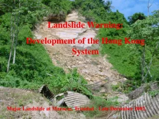
Debris Flow Warning System • Debris Flows • Rapidly moving, shallow landslides that can move large boulders, trees, stumps and other material in a slurry mixture.
Debris Flow Warning System • What it is • A system to warn residents, landowners, drivers, road managers and emergency planners when and where debris flows are expected during rain events. • Warnings are intended to provide time to prepare for an emergency period anywhere from 3 to 48 hours in advance of an event. • Immediate precautionary actions should be taken to avoid serious injury or death. • What it is not • A system to warn about more general landslide events.
Forecasting Events • ODF meteorologists have access to a variety of weather station and forecast model data. • Emergency planning grant provided funds to purchase two remote weather stations (RAWS) specifically for debris flow purposes. • East of Reedsport, south of the Umpqua River • Near Cascade Locks • Other stations would be helpful, though.
Forecasting Events Two primary events are associated with debris flows. • Long southwesterly fetch of moisture (pineapple express). • Rain on snow event. We may have to look at scenarios such as 05-06 with extended rainfall.
Forecasting Criteria Basic criteria for key locations: Inches Hours 3.0 12 4.0 24 5.5 36 7.0 48
Communications Overview NOAA Weather Radio NOAA Weather Wire NWS Web Fax, Email, Verbal NWS ODF Issues Warning DOGAMI Media Contacts DOGAMI Web ODOT Road Sign/Light Warnings OERS ODF Web Natural Hazards Incident Notification
URGENT - IMMEDIATE BROADCAST REQUESTED CIVIL EMERGENCY MESSAGE OREGON DEPARTMENT OF FORESTRY ISSUED BY NATIONAL WEATHER SERVICE PORTLAND OR 200 PM PST MON JAN 9 2006 THE FOLLOWING MESSAGE IS TRANSMITTED AT THE REQUEST OF THE OREGON DEPARTMENT OF FORESTRY. .....DEBRIS FLOW WARNING..... THE STATE OF OREGON HAS ISSUED A DEBRIS FLOW WARNING FOR CLATSOP TILLAMOOK LINCOLN WASHINGTON YAMHILL POLK AND WESTERN LANE COUNTIES EFFECTIVE BETWEEN 6 PM MONDAY JANUARY 9 AND 10 AM TUESDAY JANUARY 10. THE WARNING MEANS THAT INTENSE RAINFALL WHICH MAY INITIATE DEBRIS FLOWS IS EXPECTED WITHIN THE NEXT 4 TO 6 HOURS. DEBRIS FLOWS ARE DANGEROUS, RAPIDLY MOVING LANDSLIDES. STEEP SLOPES, CANYONS, GORGES AND THE MOUTHS OF MOUNTAIN STREAMS ARE THE LOCATIONS AT GREATEST RISK. PERSONS IN HOMES OR VEHICLES ARE AT RISK OF SERIOUS INJURY WHEN IN THESE LOCATIONS.
Debris Flow Advisories and Warnings1997- February 4, 2006 Date Type Area 16-Dec-97 Advisory Clatsop, Tillamook, western Yamhill counties 24-Nov-98 Advisory Clatsop to Coos counties 23-Feb-99 Advisory Western Oregon north of Highway 20 26-Nov-01 Advisory Clatsop to Coos counties 15-Dec-01 Advisory Northwest Oregon West of the Cascade crest and North of Highway 20 13-Dec-02 Advisory Curry County and Josephine County west of Hwy 199 and south of the Rogue River 31-Jan-03 Advisory Clatsop, Columbia, Tillamook, and Yamhill counties 13-Dec-03 Advisory Southern Lincoln, western Lane and western Douglas counties; Coos and Curry counties 29-Jan-04 Warning Clatsop, Tillamook, Lincoln, Columbia, Washington, Yamhill counties and Multnomah County east of Troutdale 30-Dec-05 Warning Coos and Douglas counties west of Interstate 5 9-Jan-06 Warning Clatsop, Lincoln, Polk, Tillamook, Washington, Yamhill counties and western Lane County
Warning Web Site Addresses • Oregon Department of Forestry: http://www.odf.state.or.us/DIVISIONS/protection/fire_protection/daily/debris.asp • Department of Geology and Mineral Industries:http://egov.oregon.gov/DOGAMI/Landslide/debrisflow1.shtml • National Weather Service Portland: http://www.wrh.noaa.gov/warnings.php?wfo=pqr • National Weather Service Medford: http://www.wrh.noaa.gov/warnings.php?wfo=mfr