Download
1 / 52
520 likes | 541 Views
This study focuses on the calibration and validation of AIRS using S-HIS infrared data, highlighting spectral resolutions and measurement precision to improve radiance observations. Key topics include radiative transfer, trace gas retrieval, and atmospheric temperature and water vapor measurements.

E N D
Atmospheric Infrared Sounder (AIRS) validation with S-HIS (Scanning High-resolution Interferometer Sounder) Hank Revercomb, David C. Tobin, Robert O. Knuteson, Fred A. Best, William L. Smith*, Paul van Delst, Daniel D. LaPorte, Scott D. Ellington, Mark W.Werner, Ralph G. Dedecker, Ray K. Garcia, Nick N. Ciganovich, H.Benjamin HowellUniversity of Wisconsin, SSEC * NASA LaRC Optical Society of America, ORS/FTS Topical Meeting, Quebec City, 3-6 February 2003
Calibration and Validation for IR radiance observationsare now concerned with tenths of K, not degrees K ! High Spectral Resolution is an important part of the reason
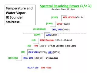
New Era: Spaceborne High-resolution IRAIRS/CrIS/IASI (LEO) to GIFTS/HES (GEO) CrIS IASI AIRS/CrIS GIFTS CO CH4 GOES Sounder CO2 N2O N2O H2O CO2 CO2 O3 H2O
TOPICS • AIRS • Scanning-HIS • Radiance Validation: • Oklahoma,ARM UAV “Grand Tour”(SHIS on Proteus at 15 km, 16 Nov 2002) • Gulf of Mexico,Terra/Aqua 2002(SHIS on ER2 at 20 km, 21 Nov 2002) • Summary
AIRS-AMSU-HSB Atmospheric Infrared Sounder Advanced Microwave Sounding Unit Humidity Sounder for Brazil
AIRS 4 May 2002 Launch NASA Aqua AIRS14 June 2002 Calculated
Non-linearity Correction Emissivity Correction EMISSIVITY AND NONLINEARITY MEASURED PRE-FLIGHT Small corrections ( 0.1-0.2 %) Uncertainty <0.1% expected (Tom Pagano, AIRS Project Manager)
SCAN ANGLE DEPENDENCE MEASURED & MODELED PRE-FLIGHT Good Agreement: Expect <0.1 K residual errors after correction (Tom Pagano, AIRS Project Manager)
Scanning HIS with Calibration Summary & 1st Uplooking Spectrum
CO2 Midwave CH4/N2O O3 H2O Longwave H2O Shortwave N2O CO2 CO UW Scanning HIS: 1998-Present(HIS: High-resolution Interferometer Sounder, 1985-1998) Characteristics Spectral Coverage: 3-17 microns Spectral Resolution: 0.5 cm-1 Resolving power: 1000-6000 Footprint Diam: 1.5 km @ 15 km Cross-Track Scan: Programmable including uplooking zenith view Applications: • Radiances for Radiative Transfer • Temp & Water Vapor Retrievals • Cloud Radiative Prop. • Surface Emissivity & T • Trace Gas Retrievals
SSEC Scanning HIS on 1st ARM-UAV Mission with Proteus, October 2002 S-HIS scans cross-track downward &looks upward
Scanning-HIS Radiometric Calibration Budget for 11/21 case TABB = 260K, THBB = 310K RSSTHBBTABBTRFLHBBABB
Scanning-HIS Radiometric Calibration Budget for 11/21 case TABB = 260K, THBB = 310K
Scanning-HIS Radiometric Calibration Budget for 11/16 case TABB = 227K, THBB = 310K
Scanning-HIS LW/MW and MW/SW Band Overlap Radiance, mW/m2 sr cm-1 LW HgCdTe band MW HgCdTe band SW InSb band LW/MW overlap MW/SW overlap
Scanning-HIS LW/MW and MW/SW Band Overlap11-16-2002 LW HgCdTe band MW HgCdTe band SW InSb band LW/MW overlap MW/SW overlap
S-HIS zenith and cross-track scanning Earth views 11-16-2002 from Proteus @ ~14km
Observed and Caculated zenith views from Proteus @ ~14km Calculated Observed Calculation based on 18Z ECMWF analysis, with 0.0004 cm H2O above 14km
AIRS SHIS • AIRS / SHIS Comparisons • A detailed comparison should account for: • instrumental noise and scene variations • Different observation altitudes (AIRS is 705km, SHIS is ~20km on ER2, ~14km on Proteus) • Different view angles (AIRS is near nadir, SHIS is ~±35deg from nadir) • Different spatial footprints (AIRS is ~15km at nadir, SHIS is ~2km at nadir) • Different spectral response (AIRS Dn=n/1200, SHIS Dn=~0.5 cm-1) and sampling SHIS and AIRS SRFs
AIRS / SHIS Comparison steps • . Average SHIS data within AIRS FOV(s) & compare • No attempt to account for view angle, altitude, spectral differences. • . Compare Residuals from calculations: (obs-calc)SHIS to (obs-calc)AIRS • SHIS and AIRS calcs each done at correct altitudes, view angles, spectral resolution and sampling. • Monochromatic calcs done using same forward model, atmospheric state, and surface property inputs. • . Difference Residuals: Spectral Resolutions made similar • valid comparison except for channels mainly sensitive to upper atmosphere, above proteus altitude
ARM UAV Campaign 19:24 UTC (daytime), Lamont Oklahoma 11/16/2002 MODIS cloud mask (green is confident clear) Aqua Sub-satellite track AIRS and SHIS 12mm brightness temperatures Proteus flight track 289K time coincidence (near ARM site) ARM offers good atmospheric knowledge 280K
MODIS 12 mBand Brightness Temperatures and selected AIRS FOVs 6 AIRS FOVs used in the following comparisons
“comparison 0” 6 AIRS FOVs, 601 SHIS FOVs, PC filtering AIRS SHIS S-HIS Spectrum Nyquist sampled without gaps
“comparison 0” 6 AIRS FOVs, 601 SHIS FOVs, PC filtering AIRS SHIS
Terra/Aqua Experiment-2002 19:40 UTC (daytime), Gulf of Mexico11/21/2002 MAS Quicklooks flight leg 5 0.65mm 1.90mm 3.74mm 11.01mm RGB Aqua Sub-satellite track ER2 Flight track MODIS cloud mask (green is confident clear) time coincidence
MODIS 12 micron Band & near-nadir AIRS FOVs 1 Degree 8 AIRS FOVs used in the following comparisons
PC Noise Filtering of SHIS and AIRS noise normalized, 20 PCs per band Original AIRS PC Filtered AIRS Original SHIS PC Filtered SHIS granule 196, scan lines 113, 114, 115; rows 45, 46. Bad_Flag==0 41 nadir spectra along flight line #5 (note: 2km spatial resolution adds real scene variability)
“comparison 0” 8 AIRS FOVs, 448 SHIS FOVs, PC filtering AIRS SHIS
“comparison 0” 8 AIRS FOVs, 448 SHIS FOVs, PC filtering S-HIS Spectrum Nyquist sampled without gaps
AIRS Compared to S-HIS, 21 Nov 2002 Black is Calculation AIRS & S-HIS Obs-Calc “Comparison 2” wavenumber
AIRS Compared to S-HIS, 21 Nov 2002 Black is Calculation AIRS & S-HIS Obs-Calc “Comparison 2” wavenumber
AIRS Compared to S-HIS, 21 Nov 2002 Black is Calculation AIRS & S-HIS Obs-Calc “Comparison 2” Different viewing angle make daytime comparisons less accurate wavenumber
observed original calc shifted calc Tb (K) original obs-calc shifted obs-calc Obs-calc (K) wavenumber Small Spectral Shift (3% of resolution) in AIRS Module-05 identified from S-HIS Validation
“Comparison 2” (21 November 2002) Excluding channels strongly affected by atmosphere above Proteus (AIRSobs-AIRScalc)- (SHISobs-SHIScalc) (K)
“Comparison 2” (21 November 2002) Excluding channels strongly affected by atmosphere above Proteus (AIRSobs-AIRScalc)-(SHISobs-SHIScalc) (K) AIRSobs (K)
Summary • The calibration uncertainty of advanced high spectral resolution observations are approaching the 0.1 K desired for climate applications • Aircraft high spectral resolution observations from Scanning-HIS [& its cousin the NPOESS Airborne Sounder Testbed (NAST)] are now proven tools for the detailed validation of satellite based observations • AIRS is providing high quality global radiances for atmospheric sounding and climate applications
Status of ARM Best EstimateT & Water Vapor Profiles: Dave Tobin • SGP files are updated thru 09 Feb 2003 • 288 overpasses to date • comparisons to T & water vapor retrievals included after 16 Nov 2002 • files and auxillary images online athttp://glacier.ssec.wisc.edu/~davet/ armBestEstimateFiles/sgp/v1.1/files.htm • NetCDF files also at weather.jpl.nasa.gov/ in /home/davet/ • Mean & Standard Deviation superior to Global Radiosondes and ECMWF
ARM Best EstimateClear Case Radiance Spectra Red = Best EstimateBlue = Sonde1Green = Sonde2Magenta = AIRSBlack = AMSU
ARM Best EstimateCloudy Case Radiance Spectra Red = Best EstimateBlue = Sonde1Green = Sonde2Magenta = AIRSBlack = AMSU
AIRS Observed-Calculated (UMBC): Clear, Night ARM BestEstimate GlobalRadiosondes
AIRS Observed-Calculated (UMBC): Clear, Night ARM BestEstimate GlobalECMWF
Comparisons of Corrected and Uncorrected Vaisala RS-80 and RS-90 Radiosonde Profiles from WVIOP2000 Corrections provided by Larry Miloshevich. The following 3 slides show comparisons of the uncorrected and corrected profiles. The first 2 slides are the RS-80s, which include all 3 corrections (rs80 time lag, contamination bias, temperature dependence calibration bias) for two representations of the contamination correction (“allage” and “maxage”) The third slide is for the RS-90s, which are corrected only for rs90 time lag.
Corrected for time lag, contamination (all-age) & T-dependent calibration
Corrected for time lag, contamination (maxage) & T-dependent calibration