Download
1 / 11
110 likes | 131 Views
Learn about AIRS data properties, distribution, and quality for improved weather forecasting, plus how to maximize its utilization in regional models.

E N D
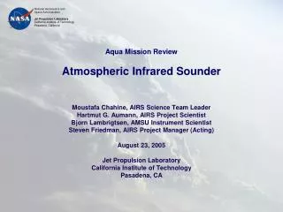
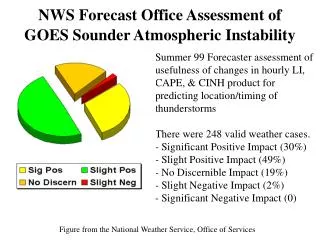
ATMOSPHERIC INFRARED SOUNDER (AIRS) AND REGIONAL DATA ASSIMILATION Brad Zavodsky University of Alabama – Huntsville Huntsville, Alabama Shih-hung Chou, Gary Jedlovec, & Bill Lapenta NASA / Marshall Space Flight Center Huntsville, Alabama Joint NASA/NOAA SOO/SPoRT Workshop July 11-13, 2006
asynoptic time over ocean Motivation • Advanced Infrared Sounder (AIRS) is a prototype instrument for the CrIS (NPOESS) and HES (GOES-R)—methodologies for AIRS data will be relevant to these upcoming instruments • The hyperspectral nature of AIRS results in the highest quality remotely sensed vertical soundings • AIRS provides complimentary data at locations and times at which traditional upper air data are not available • Important for coastal offices where knowledge of upper air conditions over ocean is generally confined to large-scale model fields 0700 UTC 20 November 2005
AIRS Specifications • Aboard Aqua polar orbiter • early afternoon equator crossing • data twice daily over SEUS at 0700 and 1800 UTC (± 1 hr) • radiances: 15 km spatial resolution (2378 spectral channels; 3.7 – 15.4 μm) • profiles: 50 km spatial resolution (3x3 footprints; 53-55 levels) • coupling with AMSU allows for retrievals in clear and cloudy scenes • verification studies have shown accuracies of 1K in 1km layers and 10-15% RH in 2km layers in troposphere
AIRS NAM Possible Uses for AIRS Data • AIRS profiles could be used in a similar fashion to rawinsondes over oceans with the caveat that temperature and dew point represent layer averages rather than point measurements • AIRS radiances can be assimilated in regional models—JCSDA currently uses AIRS radiances in global modeling • assimilating AIRS profiles is a more straightforward and less computationally rigorous method than the use of radiances • SPoRT can provide to WFOs: • - an AIRS profile product • - improved ICs (w/ AIRS) for local model runs • - a version of WRF including AIRS AIRS provides better vertical resolution than model sounding 0700 UTC 20 November 2005 (30.51oN, 72.34oW)
data questionable below 900 hPa for much of land low- to mid-level clouds present thick clouds present AIRS Data Distribution and Quality • Horizontal Distribution: • relatively narrow swath of data • maximum 2 daily overpasses • Vertical Distribution: • clouds • land emissivity (surface/low level) • Use maximum quality data: • quality indicators (QIs) allow for the removal of questionable data near surface or at/below cloud level (preprocessed with missing values) • intelligent use of the QIs allows for the maximum amount of quality data to be assimilated thereby producing the best possible initial conditions for the WRF 0700 UTC 20 November 2005 AIRS swath
L ADAS 07 UTC 1h WRF forecast 11/21/05 L GFS L 06 UTC 07 UTC 11/22/05 Validation at 00 UTC and 12 UTC 11/20/05 Surface analysis 11/20/05 12 UTC Surface analysis 11/21/05 12 UTC Surface analysis 11/22/05 12 UTC Case Study: November 20-22, 2005 • rapidly intensifying storm in region relevant to SPoRT interests • under forecasted by operational models at storm’s strongest point—potential impact • ample verification data available over the Eastern US (minimal terrain issues) WRF Domain for November 2005 Case Study L L L
ADAS Analysis with AIRS Profiles 700 hPa temperature (oC) at 0700 UTC 20 November 2005 analysis - background WRF 1h forecast analysis of AIRS data ADAS analysis • general pattern of AIRS analysis similar to background—adds validity to AIRS obs • analysis 1 – 2oC warmer than background for much of Atlantic at 700 hPa • similar magnitude at most other significant levels (some show cooling of 1 – 2oC) • analysis of mixing ratio also impacted by AIRS data (not shown)
L L L 53h Forecast Impact—Mean Sea Level Pressure Valid at 1200 UTC 22 November 2005 • low pressure area deepens by more than 4 hPa with inclusion of AIRS data • storm center shifts slightly to the south and west • both alterations are improvements over the control when compared to surface analysis
ETS for AIRS case similar to or better than the control • AIRS case bias score comparable to control 41h Forecast Impact—6h Cumulative Precipitation Valid at 0000 UTC 22 November 2005 • subtle precipitation coverage difference between control and AIRS • AIRS seems to better forecast intensity (especially over MD/DE/VA)
Summary • What can SPoRT provide to the NWS in terms of AIRS data? • AIRS profile product • available in data void regions • more vertical structure than a model field • Improved initial conditions for local model runs • intelligent use of QIs allows for assimilation of maximum high quality data • assimilation of AIRS profiles yields differences of ±1 – 2oC from background • A version of WRF including AIRS • position & intensity of low in case study improved with use of AIRS profiles • 6h QPF improved at all precipitation thresholds with use of AIRS profiles • Future plans involve running analysis/forecast with AIRS radiances using GSI/WRF configuration (W. McCarty)
The end result of this work is to provide important information to aid forecasters. Assistance from local offices in assessing the usefulness of the AIRS profiles and model runs with AIRS data would be invaluable in helping us understand the impact of AIRS data. QUESTIONS/DISCUSSION