Download

1 / 27
270 likes | 364 Views
Development of NOAA and Landsat Image Server using Web Map Service. Mr. Sarawut Ninsawat and Dr. Kiyoshi Honda. This project is a part of Education and Research Project for Sustainable Development in the Greater Mekong Sub Region supported by Japanese Government. Background.

E N D
Development of NOAA and Landsat Image Server using Web Map Service Mr. Sarawut Ninsawat and Dr. Kiyoshi Honda This project is a part of Education and Research Project for Sustainable Development in the Greater Mekong Sub Region supported by Japanese Government. 19th APAN Meeting in Bangkok
Background • GIS and remote sensing (RS) have been taking a leading role for sustainable development. • Many researchers have done numerous developments in utilizing GIS and RS data to various applications • The potential of Geoinformatics has not been fully realized in the sense that data accessibility, integrity and their integration with existing GIS databases. 19th APAN Meeting in Bangkok
Internet has high potential to give opportunities for people to access data easily. • Establishing a scheme to share and integrate geo-spatial information will contribute for the use of Geoinformatics in the society 19th APAN Meeting in Bangkok
Purpose • To develop Satellite image Map Server in AIT. • To establish mosaic image of LANDSAT over GMS countries. • Improve an access speed over WMS connection • To organize experiment for linking multiple Web Map Servers. 19th APAN Meeting in Bangkok
Introduction of web mapping technology • OpenGISConsortium (OGC) Specification • Standard interface between Client and Server • Possible to send the request as message format to multiple servers (to the distributed environment) and get the result both of text and graphic data. • Possible to develop own system independently 19th APAN Meeting in Bangkok
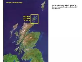
Data being provided • NOAA/AVHRR NDVI image • the 30-day composite NOAA/AVHRR NDVI shown as FCC 121. • Landsat mosaic data • Mosaic data of Thailand and GMS countries using Landsat 5 (raw Landsat scence were downloaded from http://www.glcf.umiacs.umd.edu/index.shtml) • Map data • coastline, boundaries, road, river. (VMAPO data source) 19th APAN Meeting in Bangkok
30-day NOAA/AVHRR NDVI Jan 2001 Apr 2001 July 2001 Oct 2001 19th APAN Meeting in Bangkok
Landsat Mosaic • This dataset covers 5.4 million square kilometers. Eight scenes of data were unavailable from this system. • The original projection data is UTM with datum WGS84. • The data amount of the mosaic image from 105 Landsat scenes (composed of 4 bands) is around 40 GB. 19th APAN Meeting in Bangkok
Tile index Algorithm • When handling very large raster layers, it is convenient and higher performance to split the raster image into a number of smaller images. Each file is tile of the larger raster mosaic available for display. • The list of files forming a layer can be stored in a shapefile with polygon representing the footprint of each file, and name of the files.(called Tileindex) • Mapserver will first scan the tile index and ensure that only raster files overlapping the current display request will be opened. 19th APAN Meeting in Bangkok
Two Improvement algorithms for Satellite image server 19th APAN Meeting in Bangkok
System overview (Agriculture client example) • Remote Sensing image server • NDVI 30 days data • Landsat mosaic data • For getting a request from the IT Forum client and sending to the client an image which is processed according to the request • Agriculture data client • For sending the requests to multiple server and getting the image from multiple servers and combine multiple images 19th APAN Meeting in Bangkok
System Configuration 19th APAN Meeting in Bangkok
NOAA NDVI 30 days image server example http://203.159.10.13/gms/ 19th APAN Meeting in Bangkok
Landsat image server example http://203.159.10.13/gms/ 19th APAN Meeting in Bangkok
Comparison of image quality Landsat 5 Original image Generated image from Mapserver 19th APAN Meeting in Bangkok
Comparison of image quality Png 24 bit image generated from mapserver at 400x300 size Original image from Landsat 5 image actual size is 266x209 19th APAN Meeting in Bangkok
Mobile GIS Application • User need RS images at fields • Better understanding of the site • Fast and good decision making • Limitation of PocketPC • Small System Storage (64MB – 1GB) • Impossible to store huge satellite image • Access to the Image server from fields • Wireless internet connection 19th APAN Meeting in Bangkok
RS Image Remote Sensing Image Server System configuration Spatial DB (Current position) 4) Request RS image and point layer according to latest position 5) Send image map according to requested WMS connection Minesota Mapserver 6) Combine RS image and Point Data -> Image Map GPS device PostGIS/ PostgreSQL Png,jpeg 3) Request image map from mapserver PHP Bluetooth Connection 1) Send a position data and request image map Password authorization Mobile Internet 2) Update position Pocket PC Bluetooth Connection 7) Send back image map http 19th APAN Meeting in Bangkok
Accessingto the WMS from Field using Mobile Device Mobile Application Mobile Phone GPS Bluetooth PDA 19th APAN Meeting in Bangkok
Display Image Map 19th APAN Meeting in Bangkok
Display Time of Image Map • Image File • PNG 24 bit • Image size 200 x 300 • File size is approx 20 KB • Display Time of Image Map • Thailand’s GPRS speed (40.3 kbps) around 4 second • Actual GPRS through put around 12– 13 second • EDGE Technology; 200 kbps ( 4 times faster ) 19th APAN Meeting in Bangkok
Server side image map 19th APAN Meeting in Bangkok
GISTDA&RTAF More Collaboration, More contribution 19th APAN Meeting in Bangkok
More Collaboration, More contribution 19th APAN Meeting in Bangkok
Conclusions • By implementing two algorithms ( tiling and multi-resolution ), the speed of response time was drastically improved. • Multi-server system was tested and shown its efficiency to serve images to users as background images. • The potential of OpenGIS and WebGIS like this prototype will promoting more linkage and cooperation. • The broker to organize a new growing up of WMS server is required. • Extend the utilization of RS image • Not limited to Desktop PC 19th APAN Meeting in Bangkok
Thank you . . http://mapserver.hondalab.star.ait.ac.th/gms/ http://www.tsunami.ait.ac.th 19th APAN Meeting in Bangkok