Download
1 / 8
100 likes | 287 Views
WP3 – Act. 3.2: Testing some provisions of the ICZM Protocol through local/regional demonstration projects.

E N D
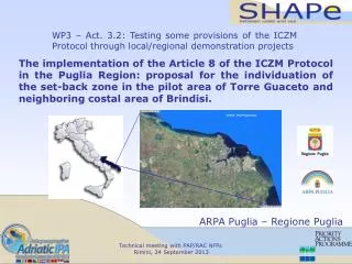
WP3 – Act. 3.2: Testing some provisions of the ICZM Protocol through local/regional demonstration projects The implementation of the Article 8 of the ICZM Protocol in the Puglia Region: proposal for the individuation of the set-back zone in the pilot area of Torre Guaceto and neighboring costal area of Brindisi. ARPA Puglia – Regione Puglia Technical meeting with PAP/RAC NFPs Rimini, 24 September2013
The Pilot Project area is characterized by the high heterogeneity of the coastal geomorphology and habitats as well as by different uses of the territory, pressures and management regimes (protected zones, touristic, urbanised and industrial ones). Due to the above mentioned characteristics, the pilot area can be considered a good test zone for the implementation of the Art. 8 of the ICZM Protocol. Technical meeting with PAP/RAC NFPs Rimini, 24 September2013
The set-back zone in the pilot area was estimated following two different steps: 1) Estimation of the set-back zone baseline, intended as “the highest winter waterline”; 2) Drawing of the set-back zone, simply created as a 100 meters buffer of the same baseline in the first approximation. The set-back zone was further adjusted widening the strip where opportune (according with its role in biodiversity protection, ecosystem maintenance and coastal adaptation to climate change and the hydraulic risk) or narrowing according to the “adaptation clause” (Article 8-2b). Technical meeting with PAP/RAC NFPs Rimini, 24 September 2013
The set-back zone baseline was estimated based on the integration of results from four different methods/approaches: 1) Empirical estimation of run-up level by means of visual check in the coastal belt. Based on the inspections on the coastal belt after the storm surges and the positioning (by GPS) of the heavy materials transported by the waves (large pebbles and relatively large and heavy tree trunks); 2) Empirical estimation of run-up level and flooding in the coastal area by means of vegetational aspects. Based on the presence/absence of the pioneer and/or structured coastal vegetation species; 3) Run-up estimation by mathematical model. This approach provided the estimation of the maximum sea level rise on the coast due to the simultaneous occurrence of the phenomena of wave set-up, wave run-up, wind set-up and tides; 4) Maximum Flooding (Tsunami impact) estimation by mathematical model. Based on the morphological features of the seabed and coastal areas, adapting hydrodynamic formulas and relevant mathematical models for the estimate of the extent of extreme flooding and risk along the coast. Technical meeting with PAP/RAC NFPs Rimini, 24 September 2013
Empirical estimation of run-up level by means of visual check in the coastal belt. Empirical estimation of run-up level and flooding in the coastal area by means of vegetational aspects. Run-up estimation by mathematical model. Maximum Flooding (Tsunami impact) estimation by mathematical model. Technical meeting with PAP/RAC NFPs Rimini, 24 September 2013
All the results from the four methods have been mapped dividing the coastline in stretches (the example of the stretch 6-7 in the figure). Technical meeting with PAP/RAC NFPs Rimini, 24 September 2013
The “integrated” set-back baseline was used to draw the set-back zone for each coastal stretch (the example of the stretch 6-7 in the figure). Technical meeting with PAP/RAC NFPs Rimini, 24 September 2013
Moreover, for each coastal stretch the information on land uses and criticalities according to the proposed set-back zone have been reported (results from the pilot project activities). An other output of the pilot project was the detailed description of the coastal geomorphologic features for each investigated stretch. You can read the full report for more and more information!!!!! Technical meeting with PAP/RAC NFPs Rimini, 24 September 2013