Determining the Location of the Northridge Blind Fault Using Advanced Modeling Techniques
This study investigates the Northridge earthquake of January 17, 1994, which had a magnitude of 6.7 and was caused by a blind thrust fault. Utilizing MATLAB PDE Toolbox and DISLOC software, we aim to precisely determine the fault's location by comparing modeling results with actual Global Positioning Satellite (GPS) readings. Our findings indicate that DISLOC software provides more accurate approximations compared to MATLAB solutions, highlighting the need for improved algorithms and the consideration of non-homogeneous crustal models in future research.

Determining the Location of the Northridge Blind Fault Using Advanced Modeling Techniques
E N D
Presentation Transcript
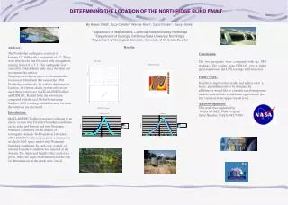
DETERMINING THE LOCATION OF THE NORTHRIDGE BLIND FAULT By Arwen Vidal3, Lucy Calvillo1, Werner Horn1, Carol Shubin1, Gerry Simila2 1Department of Mathematics, California State University Northridge2Department of Geology, California State University Northridge3Department of Geological Sciences, University of Colorado Boulder Results: Abstract: The Northridge earthquake occurred on January 17, 1994 with a magnitude of 6.7. There were aftershocks that followed with a magnitude ranging from 4.0 to 5.2. This earthquake was caused by a blind thrust fault, since the fault did not rupture the surface. The purpose of this project is to determine the location of blind fault that caused the 1994 Northridge earthquake. In order to determine its location, two linear elastic system solvers are used; these solvers are MATLAB PDE Toolbox and DISLOC. Results from the solvers are compared with the real Global Positioning Satellite (GPS) readings and differences between the solutions are discussed. Introduction: MATLAB PDE Toolbox computes solutions to an elastic system with Dirichlet boundary conditions on the sides and bottom and with Neumann boundary conditions on the surface of a rectangular domain. Jet Propulsion Laboratory (JPL) DISLOC software computes a solution for an elastic half- space model with Neumann boundary conditions. In each case, a crack, or internal boundary condition was inserted in the domain. The depth and length of the crack were given, while the angle of inclination and the slip (or deformation) on the crack were varied. Conclusions: The two programs were compared with the GPS readings. The results from DISLOC give a better approximation to the GPS readings with less error. Future Work: In order to improve the results and reduce error a better algorithm needs to be designed.In addition,we would like to consider non-homogenous models, such models would better approximate the true variation in the upper crustal level. Acknowledgements: This work was supported by NASA MURED PAIR Program Grant Number: NASA-NCC5-489 GPS Data MATLAB Graph DISLOC Graph