GPS Array for Precipitation Monitoring in Northwestern Mexico
This project aims to understand the relationship between water vapor and precipitation by deploying GPS instrumentation in Mexico to monitor variations and aid in forecasting. The data gathered will be used to enhance moisture models and improve precipitation predictions.

GPS Array for Precipitation Monitoring in Northwestern Mexico
E N D
Presentation Transcript
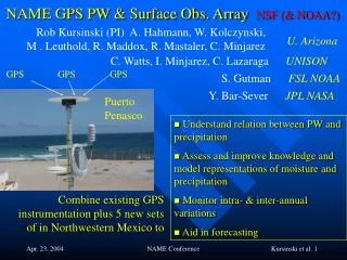
NSF (& NOAA?) NAME GPS PW & Surface Obs. Array Rob Kursinski (PI) A. Hahmann, W. Kolczynski, M . Leuthold, R. Maddox, R. Mastaler, C. Minjarez U. Arizona C. Watts, I. Minjarez, C. LazaragaUNISON GPS GPS GPS S. Gutman FSL NOAA Y. Bar-Sever JPL NASA Puerto Penasco • Understand relation between PW and precipitation • Assess and improve knowledge and model representations of moisture and precipitation • Monitor intra- & inter-annual variations • Aid in forecasting Combine existing GPS instrumentation plus 5 new sets of in Northwestern Mexico to NAME Conference
6 Existing SuomiNet sites of UA/UNISON: Phoenix, Tucson, Mt. Hopkins, Douglas, Puerto Penasco, Hermosillo GPS NAME • Place 5 (to 7) additional instrumentation sets in Mexico • GPS receiver, barometer, thermometer, hygrometer,anemometer & web cam • Locations being finalized • Measurecolumn water vapor & surface meteorological conditions • In convectively active area in SMO • In clear and cloudy conditions • 5 to 30 minute sampling • Resolve diurnal water vapor cycle • Internet for near real-time access & monitoring • FSL will provide GPS processing in near real-time at 30 minute resolution • Begin by early to mid-June • Run continuously through end of NAME Summer 04 campaign R R NAME Conference
2003 GPS & Simulation Results Monsoon in Tucson Diurnal PW variations over 4 days WRF GPS Tucson WRF simulation Mt. Hopkins Time derivative of PW NAME Conference
Impact of Ground GPS on Analyses & Forecasts Rapid time variations in moisture captured by GPS • Significantly improve the RUC moisture analyses & forecasts during periods of rapid moisture evolution • Provides detection of radiosondes getting “wet” Tucson RUC w/o GPS RUC w/ GPS GPS Sonde RUC w/o GPS RUC w/ GPS GPS Sonde Analysis 3 hr Forecast Courtesy of Seth Gutman, NOAA FSL NAME Conference