Download
1 / 30
300 likes | 423 Views
FACTORS CONTRIBUTING TO A HEAVY SNOWFALL EVENT ACROSS NORTHERN ILLINOIS DECEMBER 2009. Nathan Marsili/Stephen Rodriguez 2010 GLOM Workshop Toronto, Ontario. Introduction. Synoptic Background and Forcing Mechanisms Mesoscale Features/Forcing Mechanisms Snow/Liquid Ratios.

E N D
FACTORS CONTRIBUTING TO A HEAVY SNOWFALL EVENT ACROSS NORTHERN ILLINOIS DECEMBER 2009 Nathan Marsili/Stephen Rodriguez 2010 GLOM Workshop Toronto, Ontario
Introduction • Synoptic Background and Forcing Mechanisms • Mesoscale Features/Forcing Mechanisms • Snow/Liquid Ratios
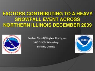
FORECAST SNOWFALL TOTALS 2 to 4 INCHES 1 to 3 INCHES AROUND AN INCH
Synoptic Overview 300 MB 12/26/09 12Z
Synoptic Overview 700 MB 12/26/09 12Z
Synoptic Overview 850 MB 12/26/09 12Z
Synoptic Overview SFC 12/26/09 12Z
Synoptic Overview DGZ 12/26/09 12Z ROAB KDVN
Phase 1: 06Z-12Z December 26th • Equally spaced west-east oriented snow bands (max reflectivity 35-40 dBZ). • Bands short-lived but multiple bands affect same areas to produce 2-4 inches of snow accumulation between midnight and 6am. • Occurred in differential negativevorticity advection region, seem to feed off shallow low level convective instability.
Horizontal Convective Rolls (HCRs) Schultz (2003) • Develop from thermal instability. • Enhanced by wind shear, but shear minimized in cross-roll direction. • Noted with large surface/air heat fluxes (warm ground/cold air).
Horizontal Convective Rolls (HCRs) B A A B Reflectivity cross section KLOT 0.5 base reflectivity 0841Z 0-2.5 km shear vectors
Phase 2: 12Z-00Z • Radar Storm Evolution 12Z-00Z
Phase 2: 12Z-00Z Synoptic Forcing • Persistent warm advection associated with slowly retreating cold dome 12Z NAM 280K
Phase 2: 12Z-00Z Mesoscale Factors • Moderate mid level frontogenesis KLOT 0.5 deg base reflectivity ~1800Z 12Z NAM 6-hr forecast 700 mb frontogenesis 12Z NAM 6-hr forecast 700 mb Fvec dvg (color-filled)
Phase 2: 12Z-00Z Mesoscale Factors • Bands become more enhanced when entering mid level frontogenesis region • In addition to area of apparent enhancement due to frontogenesis, smaller scale linear elements also noted with locally more intense snowfall rates. • Complex banding structure shows up early in the event during the overnight hours on KDVN radar.
Radar Imagery (KDVN) KDVN 0.5 base reflectivity (~ 0900Z-1130Z)
Phase 2: 12Z-00Z Mesoscale Factors • West-east banding appears to be convectively driven – horizontal convective rolls • North-south oriented bands do not necessarily line up nicely with DPVA, frontogenesis, or mid level warm advection? • Enhanced reflectivities where bands intersect (and deeper reflectivity signatures) • CSI evaluated and found not to be playing a role in this case • What else could be forcing these bands?
Phase 2: 12Z-00Z Mesoscale Factors • North-south bands may have been enhanced by gravity waves? • Enhancement of updrafts due to HCR/gravity wave interaction. Christian 87
Phase 2: 12Z-00Z Mesoscale Factors Convectively unstable capping layer Stable ducting layer
Snow to Liquid Ratios Images from SLU Snow:Liquid Research webpage (Marty Baxter)
Conclusions • Up to 1 foot of snow due to several synoptic/mesoscale factors. • Upper level low and associated isentropic lift with departing cold dome provided extended duration snowfall. • Thermal instability led to HCR development early morning producing storm total forecasted amounts by 12Z over localized areas.
Conclusions • Mid level frontogenetical forcing providing greatest snowfall rates midday. • Frontogenetical forcing co-located with deep DGZ leading to highly anomalous SLR. • Prolonged forcing combined with rare SLR’s led to very challenging forecast.
Thank you • Any questions?