Coal and Plate Motion
160 likes | 356 Views
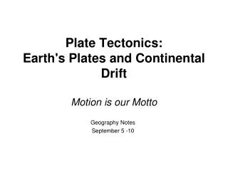
Coal and Plate Motion. Examine the USA Coal Reserves. American Coal Foundation (2010). Some Review. What environmental conditions would have been present in the states containing coal reserves during the time of coal formation? Are such conditions present today in Pennsylvania?

Coal and Plate Motion
E N D
Presentation Transcript
Examine the USA Coal Reserves American Coal Foundation (2010)
Some Review... • What environmental conditions would have been present in the states containing coal reserves during the time of coal formation? • Are such conditions present today in Pennsylvania? • What made it possible for these conditions to exist in the past?
Think about the following questions while examining the Paleomaps • After marking the approximate location of PA on each map, during which period is it most likely that coal formed in Pennsylvania and why? • Do the paleomaps give you any indication as to when the coal reserves to the west (near the Rocky Mountains) formed?
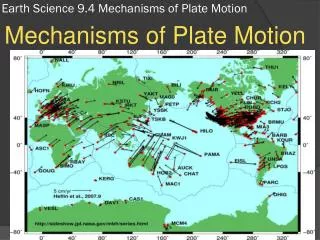
Scotese (2003) 425 Ma – During the Silurian, Laurentia collided with Baltica, which closed the northern branch of the Iapetus Ocean and formed a new continent. During this time, coral reefs expanded and land plants began to colonize on the continents.
Scotese (2003) 390 Ma – The early Paleozoic oceans continued to close during the Devonian, forming a “pre-Pangea”. Freshwater fish could migrate from continents in the southern hemisphere to North America and Europe. Also, forests began to grow in the equatorial regions of the Arctic.
Scotese (2003) 356 Ma – Pangea began to form during the Early Carboniferous as the Paleozoic oceans between Euramerica and Gondwana began to close. These closures led to the formation of the Appalachian and Variscan mountains. Meanwhile, an ice cap grew at the South Pole, and four-legged vertebrates evolved in the coal swamps near the equator.
Scotese (2003) 306 Ma – The Late Carboniferous (Pennsylvanian Epoch) is known as the time of great coal swamps. The land masses that make up modern North America and Europe collided with the southern continents of Gondwana to form the western portion of Pangea. Widespread coal swamps formed along the equator, while a lot of the southern hemisphere was covered in ice.
Scotese (2003) 100 Ma – During the Cretaceous a huge inland sea called the Western Interior Seaway cut through North America. When the Pacific and North American plates collided, the Rocky Mountains began to form in the western U.S. High sea levels led to flooding of the lowlands to the east of the Rocky Mountains. Waters from the Arctic Ocean to the north and the Gulf of Mexico to the south met to form the seaway that grew and receded during this period.
Now examine the Western Interior Seaway Map and Climate of Cretaceous Period • Do these maps (in combination with the paleomaps) give you any indication as to when the coal reserves to the west (near the Rocky Mountains) formed? • Do you see similarities or correlations between landscape and presence of coal amongst the maps?
Western Interior Seaway Map Hudson Seaway Western Interior Seaway Blakey’s Late Cretaceous Map (75 Ma)
Climate of Cretaceous Period Scotese (2003)