Download
1 / 24
240 likes | 260 Views
Comprehensive study on coal-slurry deposits in Indiana, mapping, thickness estimation, volumetric calculations, and chemical analysis. Data sources include aerial photographs and drilling data.

E N D
Reconnaissance of Coal-Slurry Deposits in Indiana Denver Harper Chris Dintaman Maria Mastalerz Sally Letsinger August 1, 2006 - April 30, 2007 Sponsor: Center for Coal Technology Research Purdue University Indiana Geological Survey Bloomington, Indiana
IGS Web Report http://igs.indiana.edu/survey/projects/Coal_Fines/index.cfm
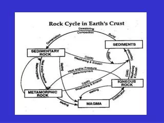
Definitions Spoil = displaced overburden Gob = coarse-grained refuse Slurry (tailings) = fine-grained refuse Spoil (Fragmented and displaced overburden) Surface Mine Preparation Plant (Washer) Mine-Run Coal (Raw Coal) Power Plant Clean Coal Reject (Refuse) Ash Coarse-grained (gob) Fine-grained (slurry, tailings)
Objectives Rapid reconnaissance using existing data in a GIS Map areal extents of coal-slurry deposits Estimate thicknesses Calculate volumes Collect preexisting chemical analyses Statistically analyze chemistry values
Mapping – Data Sources Historical aerial photographs Dates: 1937 to 1980 Source: IGS archive (160 photos) Digital Orthophoto Quarter Quads (1998) National Agricultural Imagery Program (2003) Indiana Orthophotography Project (2005)
Mapping – Feature Identification Coal-preparation plants Old Ben No. 2 2003 Tecumseh 1953 Pre 1978 Post 1978
Mapping – Feature Identification Coal slurry deposits Slurry (fine-grained) Gob (coarse-grained) Friar Tuck Mine 1974
Mapping – Depositional Settings Berms Minnehaha - 1954 Final-cut pit Airline - 1949 Spoil Chieftain 1946 1954
Results – Areal Extents Berm Final-cut pit Spoil Impoundment Not slurry
Thickness Estimates – Data Sources Existing data sets: Topography - Digital Line Graphs (USGS) Coal Mine Information System (IGS) Drilling data - National Coal Resource Data System (USGS) Historical aerial photographs
Thickness Estimations - Berms Air Quality No. 1 2003 (NOTE: Active operation. Impoundment not yet filled. Not included in final calculations.) Elevation of top of berm ~ 545 ft Elevation of bottom of impoundment ~ 445 ft Total height of Impoundment ~ 100 ft
Thickness Estimations – Final-cut pits Lynnville Mine Elevation of coal ~ 395 ft Elevation of top of final-cut pit ~ 470 – 500 ft Depth of final-cut pit ~ 75 to 105 ft
Thickness Estimations – Spoil deposits Assumptions: (1) Troughs completely filled. (2) Angle of draw = 30 degrees. (3) Aver. thickness = 1/8 ridge spacing. Latta Mine 1954 Ridge spacing = 66 feet Average depth of troughs = 66/8 = ~ 8.25 ft
Recoverable Coal - Assumptions Mineability of slurry Final-cut pits = 70 percent Spoil deposits = 60 percent Average weight density of raw slurry = 110 to 120 lbs per cubic foot Recoverable coal = 20 to 40 percent of mineable slurry Volume of raw slurry in situ = 94 to 136 million cubic yards = 22 to 69 million tons of recoverable coal “…volume of mapped CSDs represents from 22 to 69 million tons of recoverable coal. This compares with an earlier estimate made by Miller and Eggert (1982) of about 20 million tons.” - Final Report
Chemical Characterization Mine sites – 10 Drill holes – 93 Samples – 473 Collection dates – 1970s through early 1980s Analyses Sulfur (weight percent, as received) Ash (weight percent, as received) Btu per pound (as received, moisture- and ash-free)
Selected statistical values for 473 individual samples of coal slurry AR: as-received; MAF: moisture- and ash-free; wt %: weight percent
Selected statistical values for samples from various mine sites AR: as-received; MAF: moisture- and ash-free; wt %: weight percent
Slurry Disposal Preparation plant pipeline Cell 2 pipe discharge = “entry point” large, dense fragments of coal and rock Cell 1 subaerial fan coarse coal ultrafine coal and clay slurry pond “…a manmade prograding fan-delta system” -- Eggert, Miller, and Irwin (1980)
Chinook - IGS Sample Locations 1996 1946 Spreadsheet: COAL_SLURRY_ANALYSES_IGS.XLS
Chemical Trends – IGS Samples Spatial trends – Mixed results. Significant trends within several CSDs (Chinook and Lynnville), but not within others. Historical trends – Age of preparation plant versus quality of coal slurry Source coal beds – Quality of source coalbedversus quality of slurry Type of mining – Underground mines versus surface mines
“Loss of slurry or fines in washeries…is a step in the march of progress and eventually some method of utilization will be found.” - Coal Age, 1936