Download
1 / 52
520 likes | 751 Views
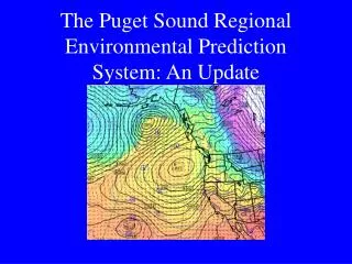
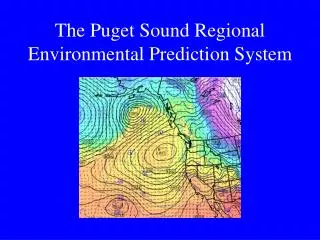
The Puget Sound Regional Environmental Prediction System.

E N D
The Big Questions:1. Can we use atmospheric models to simulate and forecast local weather features?2. Can we create an integrated regional environmental modeling system for research and prediction by coupling preexisting models and using all operational data assets?
The Atmospheric Model: MM5 The Penn. State/NCAR mesoscale model V3.5 (MM5). A full physics primitive equation numerical prediction model, it is being run: • twice a day at 36/12/4 km horizontal grid spacing. 38 levels forced by the NCEP Global Forecast System (GFS) run • 0 to 72h for 36/12 • 0 to 48 h for 4 km • Twice a day at 36/12km grid spacing forced by the NCEP Eta Model (available sooner)
Some Comments • A 4-km model does NOT resolve 4-km scale features…more like 20-25 km. • There are major issues (problems) in the physical parameterizations that we are actively working to improve, such as: • Moist physics • Land surface and boundary-layer physics • Radiation schemes
Ensemble: a 20 processor athlon cluster
WRF Cluster: The Most Powerful Computer: 32-Processor Athlon Linux Cluster
Current MM5 System • Model forecasts are verified against all regional observations • Model graphics are available on the web • Model grids are shipped to some consortium members (e.g., NWS)
A Vision of an Integrated Regional Modeling System Output from the MM5 is now being fed into a number of modeling and diagnostic systems: • Distributed Hydrological Model for Western Washington (PRISM Major Support) • Calgrid Air Quality Model • Land Surface Model for Surface Temperature Prediction • Smoke, Ventilation, and Fire Guidance • Transportation Information System And hopefully soon will be integrated with others (e.g. Puget Sound)
Terrain - 150 meter aggregated from 30 meter resolution DEM • Land Cover - 19 classes aggregated from over 200 GAP classes • Soils - 3 layers aggregated from 13 layers (31 different classes); variable soil depth from 1-3 meters • Stream Network - based on 0.25 km2 source area
Ventilation Index
U.S. Forest Service • MM5 grids are sent to the field for running Eulerian and Lagrangian smoke plume/dispersion models. • MM5 output used for fire fighting operations.
Military Applications • The NW MM5 is now the main source of regional forecasts for Navy and Air Force operations at Whidbey NAS and McChord Air Force Base, as well as the Everett Carrier homeport.
Ensemble Forecasting • A major push has been made toward ensemble forecasting using the MM5 because of initial condition and physics uncertainty. • The goal is to provide probabilistic predictions, including forecasts of model skill. • The MM5 is now being run at 36/12 km resolution with approximately 25 different initializations and lateral boundary conditions, as well as varying model physics.
Regional Ensemble Configuration • Makes use of the differing initializations (and boundary conditions) from major operational NWP centers (e.g., NCEP, Navy, Canadian, UKMET, Australian, Taiwanese, etc) and varying physics options. • Early results very encouraging (e.g., using ensembles to predict forecast skill)
Relating Forecast Skill and Model Spread Mean Absolute Error of Wind Direction is Far Less When Spread is Low
Regional Observational Database Since the mid-1980’s, have collected all available data networks in the Pacific NW Data collected and quality controlled in real-time The database is used for verification of the regional MM5 forecasts, regional application, and local research
Research on Physical Parameterizations • IMPROVE: To improve moist physics in mesoscale models using data from the Pacific Northwest. Multi-investigator project. Data from a major field experiment • PBL Parameterization Project: Evaluation and improvement of MM5 PBL schemes. Sponsored by the Forest Service
British Columbia Legend Washington UW Convair-580 Airborne Doppler Radar Cascade Mts. Two IMPROVE observational campaigns: I. Offshore Frontal Study (Wash. Coast, Jan-Feb 2001) II. Orographic Study (Oregon Cascades, Nov-Dec 2001) S-Pol Radar Offshore Frontal Study Area BINET Antenna • Olympic Mts. Olympic Mts. Paine Field Univ. of Washington NEXRAD Radar Area of Multi-Doppler Coverage Wind Profiler Rawinsonde Westport Cascade Mts. WSRP Dropsondes Special Raingauges PNNL Remote Sensing Site Columbia R. 90 nm (168 km) Washington Ground Observer S-Pol Radar Range S-Pol Radar Range 100 km 0 Portland Oregon Terrain Heights Coastal Mts. Salem < 100 m Orographic Study Area 100-500 m 500-1000 m 1000-1500 m Newport 1500-2000 m 2000-3000 m > 3000 m Rain Gauge Sites in OSA Vicinity Santiam Pass OSA ridge crest Santiam Pass Orographic Study Area S-Pol Radar Range Cascade Mts. Coastal Mts. Oregon SNOTEL sites CO-OP rain gauge sites Medford California 50 km
Modeling Winds in the Columbia Gorge Cascade Locks Portland Troutdale • Strongest winds are at the exit
1.3 km grid spacing 4-km grid spacing