Download
1 / 43
430 likes | 560 Views
A. `. Which people groups are represented in this painting? What is the focal point of this painting? What message do you think the author is trying to portray?. What is the message of this painting?. American Progress By John Gast. Do Now.

E N D
Which people groups are represented in this painting? What is the focal point of this painting? What message do you think the author is trying to portray?
What is the message of this painting? American Progress By John Gast
Do Now • Take our the homework you read last night titled “Manifest Destiny: An Introduction” • Discuss the reflection question with your group members… Are most of the reasons justifying Manifest Destiny politically motivated, economically motived or socially motivated? What does this tell us about the U.S. during this time period?
MANIFEST DESTINY evident; obvious; apparent inevitable; certain American Progress By John Gast • The belief that the United States was destined to expand from the Atlantic to the Pacific Ocean • Most movement was in the 1840s • It has also been used to advocate for or justify other territorial acquisitions • Alaska (1867) • Hawaii (1898)
Open to a fresh page of notebook paper • Write the following question as the heading on this paper… What challenges might arise in settling the West? • Make 4 columns and put “Political”, “Social”, “Physical” and “Economic” at the top • Work with your group members to come up with at least 2 challenges for each category What needs to happen in order for these Western lands to be utilized to their fullest capacity? Physical Map of the U.S.
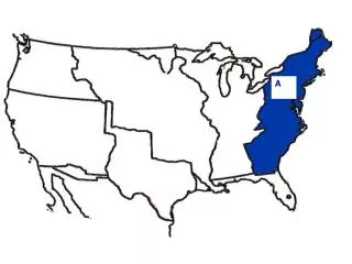
A U.S. TERRITORIAL EXPANSION Territory Name: A - 13 Original Colonies When? • 1776 From Where? • Great Britain Why? • US declared independence from Great Britain
U.S. TERRITORIAL EXPANSION Territory Name: B - Western Lands When? • 1783 From Where? • Great Britain A B Why? • Part of the agreements made in the Treaty of Paris (ended Revolutionary War)
U.S. TERRITORIAL EXPANSION Territory Name: C - LouisianaPurchase When? • 1803 B From Where? C A • France Why? • Napoleon needed $ • Jefferson wanted to buy New Orleans • He got all of this instead!
Lewis and Clark • Led first expedition to the Pacific coast (1804-1806) • Commissioned by President Thomas Jefferson to: • Establish trade routes • Find, follow and map waterways • Find natural resources • Document an American presence before Europeans could • Declare sovereignty over Native American tribes William Clark and Meriwether Lewis
Your Assignment • “The Journals of Lewis and Clark” JIGSAW • You’ll be assigned a specific topic • 1- Issues among the men • 2- Encounters with Native Americans • 3- In the Rockies • 4- Issues on the Missouri River • 5- Animal Interactions • Read through the journal entries on that topic and take notes on their experiences • Then, we’ll swap and share
Zebulon Pike • Led expedition to the South in 1806 • Goal: Find the sources of the Arkansas and Red Rivers • boundary between Spanish territory and Louisiana • Illegally crossed over into Spanish territory, was arrested and spent a year in jail • Never found the Red River • Provided the first information in English on the Great Plains and the Rio Grande Valley
Effects of Exploration 1. Accurate Maps – Valuable to later western travelers 2. Growth of Fur Trade – Boosted interest; trappers brought back knowledge of the West 3. Inaccurate view of the Plains – Pike called it a desert; led to the idea that it was not good for farming [but good for Native Americans]
U.S. TERRITORIAL EXPANSION Territory Name: D – Red River Valley D When? • 1818 C From Where? A B • Great Britain Why? • 49th parallel was determined as the border between British Canada and the U.S.
US TERRITORIAL EXPANSION Territory Name: E – Spanish Cession When? D • 1819 From Where? C A B • Spain (Adams-Onis Treaty) Why? E • Spain sold it to us for $5 million
US TERRITORIAL EXPANSION Territory Name: F - Texas D D When? • 1845 From Where? C B A • Republic of Texas • (Independent Country) F Why? E E • Texas became independent from Mexico in 1836 • Northerners feared it would become a slave state so annexation was pushed off until 1845
OREGON TERRITORY
US Territorial Expansion Territory Name: G - Oregon Territory D When? G • 1846 C C A From Where? B • Great Britain Why? • Land has been jointly occupied • Americans demanded “54° 40’ or fight!” • U.S. proposed the 49° parallel as a compromise and Britain accepted F E
US Territorial Expansion Territory Name: H - Mexican Cession D When? • 1848 G From Where? C B A • Mexico H Why? • Polk offers to buy ‘H’ from Mexico & they refuse • War erupts • In Treaty of Guadalupe Hidalgo, US offers $15 million for ‘H” F E
US Territorial Expansion Territory Name: I – Gadsden Purchase D When? G • 1853 From Where? C B A H • Mexico Why? F • Needed by the U.S. in order to complete the transcontinental railroad I E
THINK.PAIR.SHARE. • Make a chart in your notes titled: “Americans Headed West to…” • This should be 1 column wide with 7 rows • Cite factors that contributed to the sense of “expansion fever” experienced in America during the mid-19th century…
Trails West: Draw them on your map Portland, OR OREGON TRAIL Nauvoo, IL MORMON TRAIL Independence, MI Salt Lake City, UT SANTA FE TRAIL Santa Fe, NM
DO NOW…Consider: • Grab 2 DIFFERENT colored pencils • Take out your Westward Expansion maps • What do you anticipate being the benefits and drawbacks of Manifest Destiny? • Consider: • The various reasons for the move westward • The settlers point of view • The impact on Native Americans • The impact on the nation as a whole
MR. MANIFEST DESTINY • Your Assignment: • Read through the summary on President Polk. • What did he believe about expansion and how did he win the support of many states in the election of 1844? • Jacksonian Democrat • Gained support from the North and from the South • Added more territory to the US than any other President James K. Polk
The Great Plains • Prior to Civil War, this area was seen as a “treeless wasteland” • Climate: • Semiarid • Rainfall is sparse and unpredictable • does not provide enough precipitation to support trees, and grassland is the natural vegetation
What factors might PULL people to the West in the mid to late 1800s? • Opportunities for land ownership • Possibility of wealth • Gold rushes • Natural Resources: oil, sulfur, coal, natural gas • New beginning for former slaves • Adventure
New Inventions Alter Perspectives • Barbed wire • Steel Plow • Wind mills • Transcontinental Railroad
Adaptations in Lifestyle • Dry farming • Sod homes • Beef cattle raising • Wheat farming
"[w]e are not going to let a few thieving, ragged Indians check and stop the progress of [the railroads]." “The more Indians we can kill this year, the less will have to be killed the next war, for the more I see of these Indians, the more convinced I am that they all have to be killed or be maintained as a species of paupers.” William Tecumseh Sherman: Appointed as commanding general in the construction and protection of railroad development to the west of the Mississippi River
Transcontinental Railroads • Built mainly from 1850-1871 • Land grants distributed to railroad companies • Ex: 10 square miles of public land for every mile of track laid in a state and 20 square miles for every mile of track laid in a territory • Sold land to farmers and/or immigrants for $2-10 per acre
Railroad Laborers • Civil war veterans • African Americans • Mexican Americans • Irish and Chinese immigrants • By 1880, 44% of settlers in Nebraska and 70% of settlers in Minnesota and Wisconsin were immigrants Chinese Laborers
Railroad Laborers • Pay scales ranged from • $1 a day for pick and shovel workers • $4.17 a day for foremen • Seven days a week • 12 to 16 hours a day • Labored year around • below-zero temperatures of winter and the 100-degree days of summer
Railroad Companies Union Pacific (westward from Omaha, NE) Central Pacific (eastward from Sacramento, CA)
Transcontinental Railroad May 10, 1869 at Promontory Summit, Utah