ADCIRC simulations using high performance resources
ASGS – Advanced Surge Guidance System.

ADCIRC simulations using high performance resources
E N D
Presentation Transcript
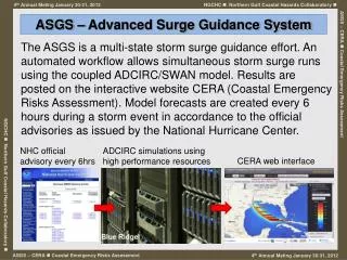
ASGS – Advanced Surge Guidance System The ASGS is a multi-state storm surge guidance effort. An automated workflow allows simultaneous storm surge runs using the coupled ADCIRC/SWAN model. Results are posted on the interactive website CERA (Coastal Emergency Risks Assessment). Model forecasts are created every 6 hours during a storm event in accordance to the official advisories as issued by the National Hurricane Center. NHC official advisory every 6hrs ADCIRC simulations using high performance resources CERA web interface
ASGS – general purpose • real-time interactive tool during emergency situations • The interactive ASGS/CERA system helps during critical emergency events by delivering real-time results which allow the emergency management to get qualified assessments of the actual situation. In combination with delivering forecast results the system runs as a prototype for decision making. • development and validation tool for coastal modelers • Modelers can use the ASGS/CERA system to validate their model, compare the results with other data sources and improve the reliability and stability of the used model code.
NGCHC goals to accomplish Extend the functionality of ASGS to AL and MS • Operational mode during the active hurricane season (June, 1 - Oct, 31 2012) forecast every 6hrs related to the official hurricane advisories as issued by the National Hurricane Center • Simulations runs of ASGS using historical storms that impacted AL and MS; compare to actual data
Hurricane season 2012 forecast Weather Channel's 2012 hurricane season forecast compared to the Colorado State forecast and the 1995-2011 average.
CERA home page http://coastalemergency.org
ADCIRC grids OCPRv19a grid = 1,091,112 nodes FEMA MS grid = 900,450 nodes SL15v7 grid = 2,734,121 nodes
New Features simplified user interface (menus, terminology) according to feedback from emergency managers 8 supported ADCIRC grids (S08, SL15v3, SL15v7, SL16, OCPR, FEMAR3, FEMAR4, EC95D) CERA site for ASGS developers will show all ADCIRC runs independent from the ASGS system in UTC;specific ASGS sites (Northern Gulf, North Carolina) will show only relevant tracks with local time zone Northern Gulf = CDT North Carolina = EDT
New Features improved ASGS functionality (individual file format support for each layer (ascii, netcdf)) improved color scales, high resolution for region of interests
New Features time series, animations, SWAN layers (significant wave height, peak wave period) maximum significant wave height significant wave height as time series every 2 hrs
New Features predicted and real-time hydrographs
New Features inspect ADCIRC attributes
Northern Gulf – historical storms ADCIRC grid: OCPRv19a (1,091,112 nodes) historical storms: Ivan (2004) Dennis (2005) Katrina (2005) Rita (2005) Gustav (2008) Ike (2008)
Summary coastalemergency.org CERA website cera.cct.lsu.edu NG-CERAwebsite • real-time interactive tool during emergency situations • off season: model development, validation, improvement