Download
1 / 11
110 likes | 332 Views
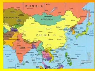
East Asia: Physical Geography. Chapter 18 Section 1: Land and Water Section 2: Climate and Vegetation Section 3: Natural Resources. Section 1: Land and Water. Landforms in China Himalayas Highest mountain range in the world. They run along the border of China and Nepal.

E N D
East Asia: Physical Geography Chapter 18 Section 1: Land and Water Section 2: Climate and Vegetation Section 3: Natural Resources
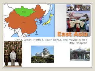
Section 1: Land and Water • Landforms in China • Himalayas • Highest mountain range in the world. They run along the border of China and Nepal. • Mt. Everest – one of the highest mountains in the world. • Located in the Himalayas • Plateau of Tibet • A large highland area that lies north of the Himalayas.
Section 1: Land and Water • Landforms that make up East Asia. • China takes up most of East Asia’s land. • High mountains and plateaus make up most of China. • Plains • China and Mongolia have wide plains while Japan, Taiwan, and the Koreas have narrow plains. • Japan is an island country in the western Pacific Ocean. • Is an archipelago – group of islands • Has 4 main islands and more than 3,000 smaller ones. • Nearly 80% is covered in mountains. • Mt. Fuji is a large mountain in Japan that is a volcano.
Section 1: Land and Water • Major rivers in China • Chang River • Deep enough for cargo ships to sail on. • The Three Gorges Dam is built across it to produce more hydroelectric power and control flooding. • Huang River: • runs through the North China Plain • Named for the brownish-yellow soil called loess (very fertile) that it carries and deposits on the North China Plain. • More than 100 million people live along its banks because it is one of the best farming areas in China. • Floods during monsoons • Dams are built to help control the flooding • Both rivers begin in Tibet and flow east.
Section 2: Climate and Vegetation • East Asia’s climate is often described as varied. • 7 different climate regions cover East Asia. • 5 major climate regions: • Semiarid, arid, humid subtropical, humid continental, and highlands. • East Asia’s climate is influenced by: • Monsoons: a wind that changes directions with the change of seasons.
Section 2: Climate and Vegetation • Climate affects what plants grow in East Asia. • Bamboo is a plant grown in southern China and Japan. • Is reliable because of its ability to stand seasonal differences in temperatures and rainfall. It can also survive dry spells.
Section 2: Climate and Vegetation • Climate also affects the diet in East Asia. • Rice: grows best in warm weather. • In Southern China rice is grown and eaten. • Wheat: grows best in cool weather. • In Northern China people eat more things made from wheat, such as noodles.
Section 3: Natural Resources • China’s Natural Resources: • Many mineral resources • Coal, copper, tin, iron, and oil • One of the largest coal suppliers in the world. • Hydroelectric power (water) • The Three Gorges Dam: • Located on the Chang River • Built to produce more hydroelectric power • Control flooding • Aquaculture: • farming of fish, shellfish, and seaweed.
Section 3: Natural Resources • Using the Land • Little Farmland: • Many mountains and plateaus • East Asian’s farm every bit of land to feed its population. • Farmers: • cut terraces: a flat area in a hillside that allows more space to grow crops. • use double cropping: growing two or more crops on the same land, in the same season, and at the same time.
Section 3: Natural Resources • The Koreas • North Korea: • developing country • Industry is not strong – weak economy • Lacks modern technology • Has mineral resources – coal and iron • South Korea: • Developed country • Industry is strong – strong economy • Advanced in modern technology • Lacks mineral resources – coal and iron • Imports the materials it needs to keep industry running
Section 3: Natural Resources • Japan • Developed country • Strong modern industry that produces many manufactured goods • Lacks natural resources • Imports a huge amount of minerals • Rich economy