Introduction to GPS: Orbiting Satellites and Navigation Systems
400 likes | 503 Views
Learn about the Global Positioning System (GPS), its history, components, working principles, accuracy levels, and applications in various fields. Understand how the GPS aids in location determination, navigation, tracking, mapping, and timing worldwide.

Introduction to GPS: Orbiting Satellites and Navigation Systems
E N D
Presentation Transcript
Introduction to the Global Positioning System An AAPT/PTRA Workshop Fred Nelson Manhattan High School
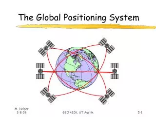
What is the GPS? • Orbiting navigational satellites • Transmit position and time data • Handheld receivers calculate • latitude • longitude • altitude • velocity • Developed by Department of Defense
History of the GPS • 1969—Defense Navigation Satellite System (DNSS) formed • 1973—NAVSTAR Global Positioning System developed • 1978—first 4 satellites launched Delta rocket launch
History of the GPS • 1993—24th satellite launched; initial operational capability • 1995—full operational capability • May 2000—Military accuracy available to all users
Components of the System Space segment • 24 satellite vehicles • Six orbital planes • Inclined 55o with respect to equator • Orbits separated by 60o • 20,200 km elevation above Earth • Orbital period of 11 hr 55 min • Five to eight satellites visible from any point on Earth Block I Satellite Vehicle
GPS Satellite Vehicle • Four atomic clocks • Three nickel-cadmium batteries • Two solar panels • Battery charging • Power generation • 1136 watts • S band antenna—satellite control • 12 element L band antenna—user communication Block IIF satellite vehicle (fourth generation)
GPS Satellite Vehicle • Weight • 2370 pounds • Height • 16.25 feet • Width • 38.025 feet including wing span • Design life—10 years Block IIR satellite vehicle assembly at Lockheed Martin, Valley Forge, PA
Components of the System User segment • GPS antennas & receiver/processors • Position • Velocity • Precise timing • Used by • Aircraft • Ground vehicles • Ships • Individuals
Components of the System Ground control segment • Master control station • Schreiver AFB, Colorado • Five monitor stations • Three ground antennas • Backup control system
How does GPS work? • Satellite ranging • Satellite locations • Satellite to user distance • Need four satellites to determine position • Distance measurement • Radio signal traveling at speed of light • Measure time from satellite to user • Low-tech simulation
How does GPS work? Pseudo-Random Code • Complex signal • Unique to each satellite • All satellites use same frequency • “Amplified” by information theory • Economical
How does GPS work? • Distance to a satellite is determined by measuring how long a radio signal takes to reach us from that satellite. • To make the measurement we assume that both the satellite and our receiver are generating the same pseudo-random codes at exactly the same time. • By comparing how late the satellite's pseudo-random code appears compared to our receiver's code, we determine how long it took to reach us. • Multiply that travel time by the speed of light and you've got distance. • High-tech simulation
How does GPS work? • Accurate timing is the key to measuring distance to satellites. • Satellites are accurate because they have four atomic clocks ($100,000 each) on board. • Receiver clocks don't have to be too accurate because an extra satellite range measurement can remove errors.
How does GPS work? • To use the satellites as references for range measurements we need to know exactly where they are. • GPS satellites are so high up their orbits are very predictable. • All GPS receivers have an almanac programmed into their computers that tells them where in the sky each satellite is, moment by moment. • Minor variations in their orbits are measured by the Department of Defense. • The error information is sent to the satellites, to be transmitted along with the timing signals.
System Performance • Standard Positioning System • 100 meters horizontal accuracy • 156 meters vertical accuracy • Designed for civilian use • No user fee or restrictions • Precise Positioning System • 22 meters horizontal accuracy • 27.7 meters vertical accuracy • Designed for military use
System Performance Selective availability • Intentional degradation of signal • Controls availability of system’s full capabilities • Set to zero May 2000 • Reasons • Enhanced 911 service • Car navigation • Adoption of GPS time standard • Recreation
System Performance • The earth's ionosphere and atmosphere cause delays in the GPS signal that translate into position errors. • Some errors can be factored out using mathematics and modeling. • The configuration of the satellites in the sky can magnify other errors. • Differential GPS can reduce errors.
Application of GPS Technology • Location - determining a basic position • Navigation - getting from one location to another • Tracking - monitoring the movement of people and things • Mapping - creating maps of the world • Timing - bringing precise timing to the world
Application of GPS Technology • Private and recreation • Traveling by car • Hiking, climbing, biking • Vehicle control • Mapping, survey, geology • English Channel Tunnel • Agriculture • Aviation • General and commercial • Spacecraft • Maritime
GPS News • http://www.gpseducationresource.com/gpsnews.htm • One–page reading exercise • Center of page—main topic • Four corners—questions & answers from reading • Four sides—specific facts from reading • Spaces between—supporting ideas, diagrams, definitions • Article citation on back of page
Military Uses for the GPS Operation Desert Storm • Featureless terrain • Initial purchase of 1000 portable commercial receivers • More than 9000 receivers in use by end of the conflict • Foot soldiers • Vehicles • Aircraft • Marine vessels
Geocaching • Cache of goodies established by individuals • Coordinates published on Web • Find cache • Leave a message • Leave some treasure • Take some treasure • http://www.geocaching.com/
Handheld GPS Receivers • Garmin eTrex • ~$100 • Garmin-12 • ~$150 • Casio GPS wristwatch • ~$300 • The GPS Store
GPS Operation Jargon • “Waypoint” or “Landmark” • “Track” or “Heading” • “Bearing” • CDI • Route • Mark • GOTO GPS/Digital Telephone
GPS Websites • USNO NAVSTAR Homepage • Info on the GPS constellation • How Stuff Works GPS • Good everyday language explanation • Trimble GPS tutorial • Flash animations • GPS Waypoint registry • Database of coordinates
Classroom Applications • Physics • Distance, velocity, time • Orbital concepts • Earth Science • Mapping • Spacecraft • Environmental Science • Migratory patterns • Population distributions • GLOBE Program • Mathematics • Geography • Technology
Classroom Applications Careers • Aerospace • Satellite vehicles • Launch vehicles • Hardware engineering • Ground control systems • User systems • Software engineering • Research careers
Kansas Science Education Standards Students will: • demonstrate the fundamental abilities necessary to do scientific inquiry • apply different kinds of investigations to different kinds of questions • expand their use and understanding of science and technology
National Science Education Teaching Standards Teachers of science • Plan an inquiry-based science program for their students • Guide and facilitate learning • Design and manage learning environments that provide students with the time, space, and resources needed for learning science
National Science Education Content Standards . . . all students should develop • Abilities necessary to do scientific inquiry • Understandings about scientific inquiry • Abilities of technological design • Understandings about science and technology • Understandings about • Motions and forces • Population growth • Natural resources • Environmental quality • Science and technology in local, national, and global challenges
Student-centered High interest Outdoors High visibility Integrated curriculum Inquiry “Where does he get those wonderful toys?”
Thanks for your interest in the Global Positioning System For more information or a copy of these slides fredlori768@cs.com