Download
1 / 7
80 likes | 401 Views
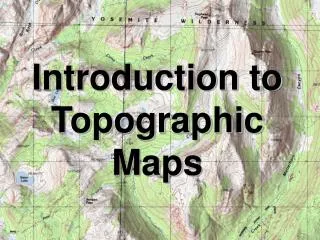
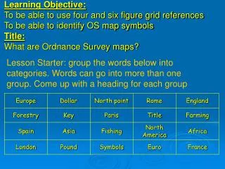
Learning Objective: To be able to use four and six figure grid references To be able to identify OS map symbols Title: What are Ordnance Survey maps?. Lesson Starter: group the words below into categories. Words can go into more than one group. Come up with a heading for each group.

E N D
Learning Objective:To be able to use four and six figure grid references To be able to identify OS map symbolsTitle:What are Ordnance Survey maps? Lesson Starter: group the words below into categories. Words can go into more than one group. Come up with a heading for each group
Introduction to OS maps What is an OS map? How do I use an OS map? How is an OS map different to an Atlas?
Comparing an OS map with an Atlas • Copy and complete the table below to show the similarities and differences between an atlas and an OS map. Remember to use the language of comparison e.g. however, whereas, on the other hand
Four Figure Grid References In which grid square is the symbol? Activity 1-4 Four Figure grid references - Hull
Scale • You can measure the size of a place from a map by using the map scale. The scale is written as a figure called a representative fraction (RF). For example, a RF of 1:50 000 shows that one unit on the map represents 50 000 of the same units on the ground. • 5 cm on a ruler on a 1:50 000 scale map would be: • 5cm x 50 000 (map scale) = 250 000cm = 2 500 metres = 2.5 km
Along the edge of a piece of scrap paper draw a line the length of the grid square - then divide it by ten - number as below Six Figure Grid References 027107 027_ _ _