Download
1 / 1
10 likes | 103 Views
Computing the Hydrologic Budget of Lake Wapalanne Diana Flores 1 , Amber Lutey 2 , Sara Kelly 3 , Jonathan Jordan 4 , Joshua Galster 1 , Duke Ophori 1 , Kirk Barrett 1

E N D
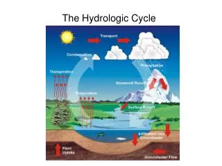
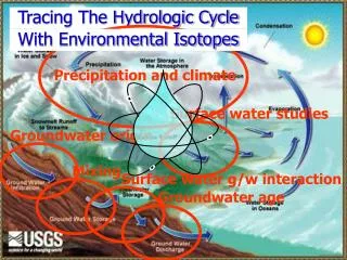
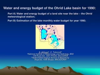
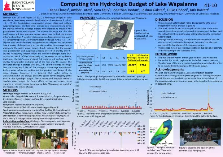
Computing the Hydrologic Budget of Lake Wapalanne Diana Flores1, Amber Lutey2, Sara Kelly3, Jonathan Jordan4, Joshua Galster1, Duke Ophori1, Kirk Barrett1 1. Dept. of Earth & Environmental Studies, Montclair State University; 2. Lehigh University; 3. California State University of Monterey Bay; 4. University of California, Riverside 41-10 ABSTRACT Between July 13th and August 3rd 2011, a hydrologic budget for Lake Wapalanne, New Jersey, was calculated based on the equation, P ± G + Si – So – ET =ΔS. Precipitation, groundwater, stream inflow and outflow, evapotranspiration, and lake water storage were measured using direct and indirect methods. Seepage meters were installed to measure the groundwater inputs and outputs. The stream discharge and the lake depth converted from pressure sensors were used to find the stream inflow and outflow. A weather station measured precipitation and water loss (evapotranspiration). The water budget model (ΔS = P ± G + Si – So – ET) was used to calculate lake storage based on collected and calculated data. A survey of the perimeter of the lake provided lake storage data in addition to the water budget model. Results indicate that the average total precipitation and evapotranspiration were 0.44 cm/day and 0.4 cm/day respectively. Stream inflow and outflow discharges were 2474 m3/day and 4018 m3/day respectively, or, expressed as an equivalent depth over the lake's area of about 5.4 hectares, 4.6 cm/day and 7.4 cm/day. Groundwater discharge out of the lake was 0.6 cm/day. The calculated change in storage was -50,227m3 and the change in storage from the survey was 2,714 m3. The change in lake storage was minimal. Surface water inflow and outflow are the greatest contributors of lake water storage; however, it is believed that water inflow is underestimated in this analysis and is the source for the majority of the error in the hydrologic budget. These results and methods create a baseline water budget for future efforts to use and expand upon research on climate change by providing Lake Wapalanne as model of lake response to climate change. PURPOSE: To calculate the hydrologic budget of Lake Wapalanne. • DISCUSSION • The computed water budget (Table 1) was less than the water budget from the GIS analysis (Figure 4). • There are several factors as to why this came to be. There were several storm drains/small ephemeral streams around the lake, and the inflow from these drains were not inputted into the computed water budget. • Seepage meters were only placed on the western side of the lake due to the rocky substrate throughout the rest of the lake that prevented the installation of the seepage meters. • The seepage meters also leaked, possibly producing higher estimate and contributing to the calculated error. • FUTURE WORK • This was the first year of a three year study of Lake Wapalanne. • Data collection should begin earlier in the field season next year. • The discharge of the storm drains should also be calculated in order to be inputted into the computed hydrologic budget. • Acknowledgements • We wish the thank the National Science Foundation Research Experience for Undergraduates (REU) Program for funding this project and Bill Thomas and Randy Fitzgerald at the New Jersey School of Conservation and numerous Americorps volunteers for their assistance in data gathering. Figure 1. The location and air photograph of Lake Wapalannne. Table 1. The hydrologic budget summary where the measured hydrologic field data compared to the GIS and survey data are unfortunately not equal. METHODS Hydrologic Budget Model: ΔS = P ± G + Si – So – ET Where: DS = change in lake storage; P = precipitation; G = groundwater; Si= stream inflow; So= stream outflow; ET = evapotranspiration Lake Storage: Bathymetry: Topcon Total Station, (Figure A) Changes in depth: HOBO U20 Water Level Logger (Figure B) Depth versus area and volume relationships: ArcMap 10, Spatial Analyst Precipitation: Davis Instruments Vantage Pro2 weather station (Figure C) Groundwater: 2 different seepage meter designs were used (Figure D) and a total of 7 seepage meters were placed throughout the lake. Surface Inflow and Outflow: Discharge: Electromagnetic velocity probe and Sixty percent method for measuring water velocity and depth recorded with HOBO U20 Water Level Logger Figure 2. The behavior of precipitation and evapotranspiration, in cm/15 minutes, over a 27 day period. Figure 4. The discharge, in cm3/m, of the inlet and the outlet to the lake. Figure 5. The digital elevation model of Lake Wapalanne showing the survey points. Figure 6. Students and advisors of the summer 2011 REU program. Figure 3. The loss and gain of groundwater, in cm/day, over a 13 day period for each seepage bag. Figure A. Topcon Total Station Figure B. HOBO U20 Water Level Logger Figure C. Vantage Weather Station Figure D. Seepage meter design