Download
1 / 18
190 likes | 234 Views
Learn about the historical background of census taking in Namibia, establishment of GIS, geocoding system, software used, and the databases and data layers utilized for mapping. Discover how GIS has revolutionized spatial data handling for the country's development.

E N D
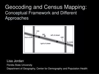
GEOCODING AND CENSUS MAPPING WITH GIS IN NAMIBIA BY Ms Ottilie Mwazi Central Bureau of Statistics E-mail: omwazi@npc.gov.na Tel: +264 61 283 4060 29 May 2007
Content of Presentation HISTORICAL BACKGROUND OF CENSUS TAKING IN NAMIBIA GIS ESTABLISHMENT GIS SOFTWARE GEOCODING SYSTEM SUMMARY CONTENT OF GIS DATABASE GIS TOOL DEMONSTRATION
Census undertaken • Before independence – did not cover all areas • 1991 first -post independence census – first census to cover the whole country used traditional mapping method • 2001 second post-independence census – covering whole country • GIS was created and 2001 census used digital maps for census enumeration
GIS establishment at CBS In order to handle spatial data effectively, CBS moved away from analog to digital mapping by creating a GIS during 2001 census The main aim was to facilitate the production of base maps needed for fieldwork GIS infrasctrure was acquired and set up with assitance of the consulting firm at Government cost Spanish government gave a photocopier/scanner for large maps and 4 x 4 vehicles for census mapping Collect missing spatial data during census mapping
Establishment of GIS continue… • Data warehouses using existing spatial data from various sources were created • Spatial data needed for census undertaking was extracted and GIS database was created • The GIS database was used to capture and digitize spatial data collected from the field • Non-spatial data was captured in Nam-grabber based on MS Access
Establishment of GIS continue.. • The country was demarcated into unique geographical areas known as enumeration areas and were captured into the database • GPS (handheld and differential) were used during fieldwork • The GIS has made it possible to retrieve, update, link (census/survey data to the geography), query the database, print maps on based on any theme, etc.
Software • Mapping software that is currently in use is GEO-MEDIA 6.0 and ArcGIS 9.2 • ER Mapper and IDRIS ANDERS are being acquired • Other mapping software i.e, ARCVIEW and MAPINFO were introduced to help with the processing of field returns and production of thematic maps.
Geocoding system • All enumeration areas were given unique code numbers composed of nine digits • numbers help to identify each EA by the level of administrative area • Rural EAs are identified with code ‘99’, while the urban EAs are coded ‘01 • A constituency with two urban centers will have ‘01’ for the first urban center and ‘02’ for the second urban center
Geocoding continue… • 1st and 2nd digits represent the region • 3rd and 4th digits represent the constituency • 5th and 6th digits represent the rural/urban status • 7th, 8th and 9th digits represent the EA number within the constituency
Boundaries Constituency boundaries Regional boundaries National boundary National park boundary Conservancy boundaries Farm boundaries Communal land boundaries Townland boundaries Locality boundaries Namplan Accommodation Basic education Health facilities Localities Service stations Towns and villages Ministries Police stations Higher education Summary of databases and data layers in the GIS
Map indexes Topographic maps 1: 50000 Topographic maps 1: 250000 Aerial photographs Land satellite images Master sample frame Master sample frame ‘02 Master sample updates ‘05/06 Boundary descriptions Thematic data Agro-ecological zones Rainfall Soil types Vegetation types Town data Townlands Cadastral Streets Street names Townships
Namibia census Namibia 1991 EAs Namibia 2001 EAs Namibia 2001 SAs Hydrology Lakes and pans Rivers Other infrastructure Roads Railway lines Power lines
Thematic maps Maps based on any theme can be produced using the available software by linking the results to the geography or area of study. These can be printed out as hard copies or they can be viewed on the computer or handed out in electronic form. However there are limitations with such outputs as they cannot be manipulated further. Therefore advanced dissemination tools such as GIS-Web based system, etc. can be introduced.
What is a WEB-based spatial information system? It is a GIS that is accessible to users through the Intranet/Internet
How does it work? • Users access all information through CBS’ Internet Webmap application – similar to visiting a web site. • User can do basic queries; generate and download reports, tables, graphs and maps • User can request data updates through web application • CBS maintains data, system hardware, software, application • Application is scalable – grow as the needs grow
Key features of WEB-GIS • It provides fast and easy access to information that is linked to geographical location • Dynamic • Interactive • Can be used for information dissemination and data maintenance • Easy to use (need minimal training) • No GIS expertise required • Scalable: can be expanded
Who can use it? • Everybody involved in development planning! Examples include: • Decision makers: national and regional • Planners: national and regional • Sector ministries • Parastatals • Private sector • The population at large • The international community • Access to the system controlled by normal internet security profiles
---End of presentation--- & THANK YOU FOR YOUR ATTENTION!!!