Geospatial Search Interface for UNH Digital Library Collections
PLACE is a geospatial search interface using embedded coordinates to facilitate discovery of hard-to-locate information. It enables users to zoom to a region on a web map and explore UNH Digital Library collections intersecting the area. The tool integrates Fedora Commons and Open Geoportal software to enhance geospatial-ready collections. Users can search collections based on polygon extents such as county polygons. Future plans include a time series tool and usability improvements. The project aims to contribute open source code to the Fedora Commons and Open Geoportal communities.

Geospatial Search Interface for UNH Digital Library Collections
E N D
Presentation Transcript
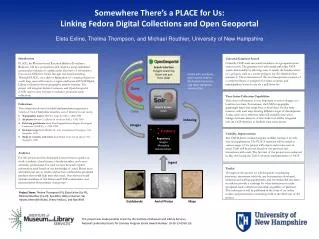
Introduction PLACE, the Position-based Location Archive Coordinate Explorer, will be a geospatial search interface using embedded geospatial coordinates to enable easier discovery of information that can be difficult to locate through text-based searching. Through PLACE, via a click or delineation of a search polygon on a web map, users will zoom to a region and locate all UNH Digital Library collections whose geographic extents intersect. The project will integrate Fedora Commons and Open Geoportal (OGP) open source software to enhance geospatial-ready collections. Universal Gazetteer Search Currently OGP users can search metadata via a geospatial zoom extent search. The gazetteer tool will extend and refine OGP search functionality by allowing users to search the border extent of a polygon, such as a county polygon, for all collections that intersect it. The construction of this tool incorporates creation of a common library of polygons for states, counties, and municipalities/towns to use via a pull down list. Search Interface Polygon searching Zoom and pan Time slider PLACE will contribute open source code to the Fedora Commons and Open Geoportal communities. Somewhere There’s a PLACE for Us:Linking Fedora Digital Collections and Open GeoportalEleta Exline, Thelma Thompson, and Michael Routhier, University of New Hampshire Query Search Server Index Time Series Collection Capabilities Time series information is very important to assess changes at a location over time. For instance, the USGS topographic quadrangle maps may range four or more dates for the same location, with each map showing different stages of development. A time series cross reference table will establish time series linkages between datasets. A time slider tool will be integrated into the OGP interface to facilitate time series access. Collections The collections chosen for initial implementation represent a variety of New Hampshire materials our of interest to our users: Topographic maps USGS 15’ maps for NH, c. 1880-1950 Air photos Brown Co. photos of northern NH, c. 1942-1943 Field trip guidebooks from New England Intercollegiate Geological Conference (NEIGC), c. 1920-1989 Geologic maps from Hitchcock, Atlas accompanying the Geology of New Hampshire, 1878 Maps of counties and towns from Hurd, Town and city atlas of New Hampshire, 1892 Data Indexing Images Repository Images Metadata Relationships Usability Improvements The UNH Library conducts regular usability testing of its web sites and applications. The PLACE interface will be tested at various stages of the project with expert and novice users in mind. Tasks will be chosen based on our personas and interactions with users. The first test of the project was conducted in May 2014 using the Tufts University implementation of OGP. Audience For this project we have developed four personas to guide our work: a student, a local citizen, a faculty member, and a non-university professional. For each we have devised a typical information need based on our knowledge of actual library users and initial user survey results, and we have outlined the geospatial products that would help meet that need. Our advisory board includes members of the Fedora and OGP communities, and representatives from primary user groups. Ingest Toolkit Throughout this project we will document our planning processes, assessment methods, any best practices developed, technical and staffing requirements, and recommended resources in order to provide a roadmap for other institutions to make geospatial-ready collections accessible, regardless of platform. This information will be published in the form of an online toolkit, and presented via workshops held in the third year of the project. Project Team: Thelma Thompson (PI), Eleta Exline (Co-PI), Michael Routhier (Co-PI), IlyaAtkin, Betsy Coleman, Val Harper, Meredith Ricker, Sherry Vellucci, and Rob Wolf. Guidebooks Aerial Photos Maps This project was made possible in part by the Institute of Museum and Library Services, National Leadership Grants for Libraries Program (Grant Award Number: LG-05-13-0350-13).