Download
1 / 7
90 likes | 331 Views
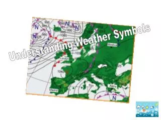
STANDARD GRADE WEATHER SYMBOLS. John Smith Invergordon Academy Malcolm McDonald Bathgate Academy. HOW IS WEATHER SHOWN ON A WEATHER MAP? (1). TV & NEWSPAPER WEATHER SYMBOLS. TYPICAL MEDIA WEATHER MAP. Look at the symbols. . What weather does Eastern England have?

E N D
STANDARD GRADEWEATHERSYMBOLS John Smith Invergordon Academy Malcolm McDonald Bathgate Academy
HOW IS WEATHER SHOWN ON A WEATHER MAP? (1) TV & NEWSPAPER WEATHER SYMBOLS
TYPICAL MEDIA WEATHER MAP Look at the symbols. What weather does Eastern England have? What is the weather like in Northern Scotland ?
HOW IS WEATHER SHOWN ON A WEATHER MAP? Temperatureis shown at the top left of the circle Present weatheris shown by the symbol at the bottom left of the circle Drizzle Present weather Mist Fog Thunder Drizzle Rain Snow Shower Heavy rain Heavy snow Hail The shower symbol can be combined with others…. Rain shower Hail shower Snow shower
HOW IS WEATHER SHOWN ON A WEATHER MAP? Wind direction and wind speed Wind direction is shown by a line leading into the station circle. This symbol shows that the wind blew into the station circle from the east The speed is shown by a series of “feathers” A circle round the station shows that there was no wind : calm
HOW IS WEATHER SHOWN ON A WEATHER MAP? (3) Clear sky 1 okta 2 oktas 3 oktas 4 oktas 5 oktas 6 oktas 7 oktas 8 oktas Overcast obscured Cloud cover is shown by the amount of shading inside the station circle. Cloud cover is measured in oktas Eighths of the sky ! I hope it doesn’t cloud over © Microsoft Word clipart
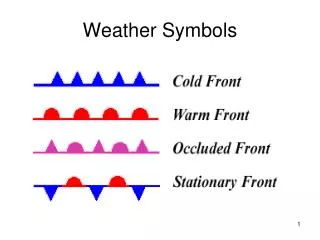
FRONTS ON WEATHER MAPS Warm fronts are shown by the following symbol. Cold fronts are shown by the following symbol. There is a third type of front that we will study later – the OCCLUDED front. They are shown by the following symbol.