Download
1 / 33
330 likes | 455 Views
Regional Climate Models And Linkages to Agricultural Models Linda O. Mearns National Center for Atmospheric Research. Agriculture and Forestry GHG Modeling Forum Sheperdstown , West Virginia September 27, 2011. Outline. Uncertainties about Climate Change

E N D
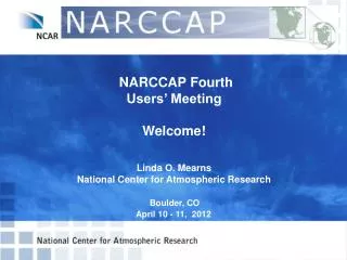
Regional Climate Models And Linkages to Agricultural Models Linda O. Mearns National Center for Atmospheric Research Agriculture and Forestry GHG Modeling Forum Sheperdstown, West Virginia September 27, 2011
Outline • Uncertainties about Climate Change • The issue of spatial scale of scenarios - results of NARCCAP • Applications to Agriculture Models • Concluding Remarks
Uncertainties about Future Climate • The future trajectory of emissions of greenhouse gases (based on uncertainties about how the world will develop economically, socially, politically, technologically) • Explored through the development of scenarios of future world development • How the climate system responds to increasing greenhouse gases. • Explored through use of climate models • Spatial scale at which climate models are run is an additional source of uncertainty • The natural internal variability of the climate system
Deep uncertainties we can’t readily quantify • Incomplete knowledge of physical processes • Model structure (including important feedbacks within the climate system) • Catastrophic extreme events - e.g., collapse of the Greenland Ice Sheet
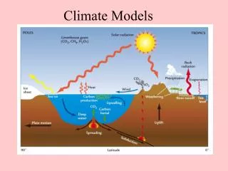
The Climate System System is simulated using climate models
North American Projections(end of 21st century, assuming A1B scenario) • Based on 21 global climate model results – expert judgment of model results • Note model limitations (e.g., coarse spatial resolution of models, ~ 2 deg.) IPCC, 2007, Christensen et al. , Chapter 11
Temperature and precipitation changes with model agreement (2080-2099 minus 1980-1999) A1B Scenario
Uncertainty due to Spatial Scale of Climate Simulations Dynamical Downscaling
What about higher resolution information about climate change? • Global models run at about 200 km (120 mile) spatial resolution - what resolution do we need for adaptation purposes • How to balance the desire for higher resolution with the other major uncertainties (future emissions, general response of climate system).
Global Climate Models Regional models
What high resolution modelingis really useful for In certain specific contexts, provides insights on realistic climate response to high resolution forcing (e.g. mountains)
Different Kinds of Downscaling • Simple (Giorgi and Mearns, 1991) • Adding coarse scale climate changes to higher resolution observations (the delta approach) • More sophisticated - interpolation of coarser resolution results (Maurer et al. 2002, 2007) • Statistical • Statistically relating large scale climate features (e.g., 500 mb heights), predictors, to local climate (e.g, daily, monthly temperature at a point), predictands • Dynamical • Application of regional climate model using global climate model boundary conditions • Confusion can arise when the term ‘downscaling’ is used – could mean any of the above
Regional Modeling Strategy Nested regional modeling technique • Global model provides: • initial conditions – soil moisture, sea surface temperatures, sea ice • lateral meteorological conditions (temperature, pressure, humidity) every 6-8 hours. • Large scale response to forcing (100s kms) • Regional model provides finer scale (10s km) response
The North American Regional Climate Change Assessment Program (NARCCAP) • Explores multiple uncertainties in regional • and global climate model projections • 4 global climate models x 6 regional climate models • Develops multiple high resolution regional (50 km, • 30 miles) climate scenarios for use in impacts and • adaptation assessments • Evaluates regional model performance to establish • credibility of individual simulations for the future • Participants: Iowa State, PNNL, LNNL, UC Santa Cruz, Ouranos (Canada), UK Hadley Centre, NCAR • Initiated in 2006, funded by NOAA-OGP, NSF, DOE, USEPA-ORD – 5-year program www.narccap.ucar.edu
Organization of Program • Phase I: 25-year simulations using NCEP-Reanalysis boundary conditions (1980—2004) • Phase II: Climate Change Simulations • Phase IIa: RCM runs (50 km res.) nested in AOGCMs current and future • Phase IIb: Time-slice experiments at 50 km res. (GFDL and NCAR CAM3). For comparison with RCM runs. • Quantification of uncertainty at regional scales – probabilistic approaches • Scenario formation and provision to impacts community led by NCAR. • Opportunity for double nesting (over specific regions) to include participation of other RCM groups (e.g., for NOAA OGP RISAs, CEC, New York Climate and Health Project, U. Nebraska).
NARCCAP PLAN – Phase II A2 Emissions Scenario GFDL CGCM3 HADCM3 CCSM3 CAM3 Time slice 50km GFDL Time slice 50 km Provide boundary conditions 2041-2070 future 1971-2000 current CRCM Quebec, Ouranos RegCM3 UC Santa Cruz HadRM3 Hadley Centre MM5 Iowa State ECPC RSM Scripps WRF PNNL
AOGCM-RCM Matrix AOGCMS RCMs
CCSM-driven change in summer temperature
CGCM3 – Global RegCM3 CGCM-driven % Change in Winter Precipitation CRCM WRFG
Southern Rockies CRCM ΔP = - 8 % MM5 ΔP = -15% WRFG ΔP = - 3%
The ‘Mismatch’ of Scale Issue “Most GCMs neither incorporate nor provide information on scales smaller than a few hundred kilometers. The effective size or scale of the ecosystem on which climatic impacts actually occur is usually much smaller than this. We are therefore faced with the problem of estimating climate changes on a local scale from the essentially large-scale results of a GCM.” Gates (1985) “One major problem faced in applying GCM projections to regional impact assessments is the coarse spatial scale of the estimates.” Carter et al. (1994) ‘downscaling techniques are commonly used to address the scale mismatch between coarse resolution GCMs … and the local catchment scales required for … hydrologic modeling’ Fowler and Wilby (2007)
Selected RCM Impacts • Mearnset al., 2001 - application to corn, wheat, and soybeans in Great Plains • Mearns et al., 1999 – Great Plains – comparison of different crop models • Oleson et al., 2007 – maize suitability – (combined uncertainties) • Qian et al., 2011 – using regional climate models in crop modeling
Uncertainty due to spatial scale of scenario RCM GCM -10.7% -10.7 2.3 % Mearns et al., 2001
Uncertainty of Impacts Models Agriculture – Corn Change in Yield T/ha EPIC Model CERES Model CSIRO Coarse Scenario Mearns et al., 1999
Combined Uncertainties - GCMs, RCMs, Emissions Oleson et al., 2007, Suitability for Maize cultivation Based on PRUDENCE Experiments over Europe Uncertainties in projected impacts of climate change on European agriculture and terrestrial ecosystems based on scenarios from regional climate models a. 7 RCMs, one Global model, one emission scenario b. 24 scenarios, 6 GCMs, 4 emission scenarios Conclusion: uncertainty across GCMs (considering large number of GCMs) X emissions scenarios larger than across RCMs, BUT uncertainty from RCMs larger than uncertainty from only GCMs used in PRUDENCE
Canadian Crop Model Study • Uses results from two of the NARCCAP RCMs – CRCM driven by CGCM3; HadRM3 driven by HadCM3 • Applied to DSSAT crop models (cereals, soybeans, potatoes) • 7 locations in Canada • Evaluates use of direct RCM output in crop modeling Qian et al., 2011
Concluding Remarks • Spatial scale of climate information about the future is an important factor in determining the impacts of climate change on agriculture • But, there a number of choices to be made on how one attains higher resolution • Still a lot of work remains in establishing that higher resolution information from RCMs is more credible than other means of downscaling • Importance of placing uncertainty related to scale in context of other uncertainties about climate change