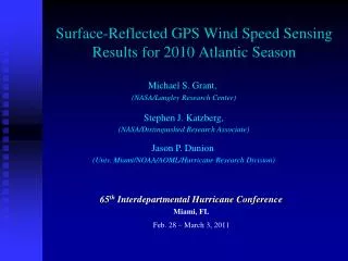
Wind speed by GPS Surface Reflection
Wind speed by GPS Surface Reflection. Results from 2007 & 2008 with some comments related to future applications. Dr. Stephen J. Katzberg Distinguished Research Associate NASA Langley Research Center. GPS Surface Reflection 2008.

Wind speed by GPS Surface Reflection
E N D
Presentation Transcript
Wind speed by GPS Surface Reflection Results from 2007 & 2008 with some comments related to future applications Dr. Stephen J. Katzberg Distinguished Research Associate NASA Langley Research Center
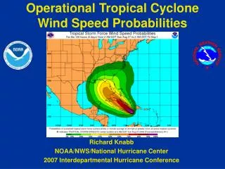
GPS Surface Reflection 2008 • Data acquired from Erin, Felix in 2007 and Fay, Gustav, Ike, Kyle and Paloma in 2008. • A Selection of retrievals will be shown comparing reflected GPS with Flight Level, dropsondes and SFMR where available. • Comparison of GPS retrievals with dropsondes to be presented. • Alternative retrieval techniques with application to UAV’s will be presented.
Felix September 2, 2007 Comments: Felix was a very powerful storm. NHC report maximum wind speeds of 163 kt (SFMR), 192 kt, dropsonde, 152 kt Flight Level and others. GPS retrieved about 110 kt.
Fay August 19, 2008 Maximum winds reported for 0430 Z H*Wind analysis 49 knots (24.5 m/s). Note the effect of : Eye Land Location (time) sift for some features. Causes some “outliers” in comparisons.
Ike September 12, 2008 Comments: No Flight Level available. H*Wind used 93 knots (46.5 m/s) based on 1145 Z buoy GPS wind speeds above 40 m/s
Tropical Storm Kyle Comments: Excellent set of retrievals compared to dropsondes. Note again effect of land, probably fetch followed by loss of signal
Comparison of GPS Derived Winds with Dropsondes Five different storms that included both GPS data and dropsonde data were analyzed. The dropsonde data were obtained from HRD website Some outliers such a values from within eye and some near land values removed Dropsondes might not be completely QC’d (FRD files) .
RQ-4 Global Hawk New flight platform for joint NOAA & NASA use. Endurance of more than 31 hours Capability to take more than 1500 lb (680 kg) of payload Altitude of 65,000 ft (20 km) Cruises at 350 knots New platform opportunity
Alternative Retrievals with Applications to UAV’s • The GPS Surface Reflection technique measures surface roughness and reflectivity. • GPS Surface Reflection wind speed retrievals can be done in three modes: matched filter, altimeter , and radiometer. • Altimeter mode monitors the peak of the reflected signal in similar way TOPEX or JASON measures wind speed. • Emissivity is related to reflectivity as R=1-ε, thus monitoring the reflected power gives monitors emissivity. Similar to microwave radiometers
Alternative Retrievals with Applications to UAV’s (cont.) • Matched filter technique “fits” model waveforms to the signal. The “pixel” size increases with wind speed. • Altimeter mode monitors the peak of the reflected signal. • This peak occurs for Reflected GPS after one code chip completely “paints” the surface. The effective size of this “pixel” is: and is not wind speed dependent. At 3km this is 1.9 km (~SFMR.) At 18 km (~60,000ft) this is 4.68 km
Alternative Retrieval Methods: Altimeter Mode Altimeter mode Uses peak signal of the first range bin on the ocean surface similar to altimeters e.g. TOPEX. Effective pixel size is wind speed independent Useful for high altitude UAV’s such as Global Hawk.
Conclusions • Retrievals based on the use of Reflected GPS (RGPS) for several hurricanes and tropical storms from 2008 have been presented. • Comparisons with dropsondes were given to demonstrate the effectiveness of the technique. • Some considerations for use of the GSRE on high altitude UAV’s have indicated the technique is applicable to this platform.
Paloma November 8, 2008 Comments: No dropsondes available. H*Wind used 119 knots (53.9 m/s) from 1727 Z SFMR43.
Fay August 14, 2008 Comments: Genesis flight
Ike September 10, 2008 Comments: No Flight Level available yet, H*Wind used 69 knots (34.5 m/s) at 1330 Z
Gustav August 31, 2008 Comments: H*Wind used maximum wind speed of 86 knots (43 m/s) as input from dropsonde.
Gustav Sept. 1, 2008 Comments: No dropsondes, H*Wind used 89 knots (44.5 m/s) at 1030 Z and 81 knots (40.5) m/s)
Gustav August 30, 2008 Comments: H*Wind used AFRC SFMR peak winds of 91 knots (45.5 m/s) at 1030 Z.
Comparison of GPS Derived Winds and Dropsondes Five different storms that included both GPS data and available dropsonde data were analyzed. The dropsonde data were obtained from HRD website Dropsondes might not be completely QC’d (FRD files) . Includes some outliers and data from within eye where GPS typically still shows abut 10 m/s retrieval. Also some near land values.